
Old Averserstrasse

The Alte Averserstrasse is a more recent historical traffic route in the canton of Graubünden between Juf im Avers and the Rofflaschlucht on the border with the Schams .
history
The road was built as the last access road in the canton of Graubünden, after all other valleys had already been developed with "commercial roads". In 1893 the road to the Valle di Lei bridge above Innerferrera was under construction. During the construction period, pedestrians had to move to the other side of the river.
Before and during the construction of the road, the whole of Madris and the upper Avers valley were oriented towards the Italian Chiavenna . Many goods were brought in via the 2649 m high Madrisberg (today Bochetta di Lägh ) or the Passo del Lago . The post was brought to Cresta on foot by the postman and parcels over five kilograms were left in Andeer , where they could be picked up by the intended recipient.
The construction of the road and the new, simpler supply resulted in a new movement of goods in the opposite direction, with tobacco, chocolate, coffee and sugar being smuggled.
Commercialstrasse from 1895, which had been abandoned since the construction of a modern cantonal road, was replaced by the Alte Averserstrasse association, including the engineering structures, such as B. several natural stone bridges , repaired in years of work and released in 2005 for non-motorized traffic. The « Walserweg Graubünden », a long-distance hiking trail from San Bernardino to St. Antönien and into the Montafon, which follows in the footsteps of the Walsers in the canton of Graubünden for over 300 kilometers , uses the Alte Averserstrasse on stages 8 and 9, although it is significantly younger than the first settlement by the Walser.
In January 2010 the Alte Averserstrasse received second place in the award ceremony of the “Prix Rando”, which honors original, innovative and high-quality hiking trails.
photos
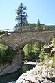
Bridge in Avers Cröt
Bridge in Cröt, covering made of calcite

Bridge at Avers Cresta

Alte Averserstrasse near Avers Cröt, around 1900


Web links
- Official website of the Alte Averserstrasse association
- Hiking route 757: Alte Averserstrasse (stage 1) and (stage 2) on the tourism website of the canton of Graubünden.
Individual evidence
- ^ Johann Rudolf Stoffel: The Avers high valley, Graubünden. The highest municipality in Europe. Zofingen 1938.
- ↑ Hiking route 35: Walserweg Graubünden on the tourism website of the Canton of Graubünden.
- ↑ Alte Averserstrasse awarded the “Prix Rando”. In: Southeastern Switzerland . Edition of January 15, 2010, p. 5.