
Rheinwaldhorn
| Rheinwaldhorn | ||
|---|---|---|
 Rheinwaldhorn |
||
| height | 3402 m above sea level M. | |
| location | Ticino / Graubünden border , Switzerland | |
| Mountains | Adula Alps | |
| Dominance | 35.1 km → Bifertenstock | |
| Notch height | 1337 m ↓ San Bernardino Pass | |
| Coordinates | 722 935 / 150398 | |
| Topo map | Swisstopo 1: 25000 sheet 1253 Olivone | |
|
||
| First ascent | Placidus a Spescha , June 1789 | |
| particularities | highest peak in Ticino | |

The Rheinwaldhorn , Italian according to Adula or Pizzo del Cadabi , Rhaeto-Romanic Piz Valrain or Piz Valragn or Pez Valrein , is at 3402 m above sea level. M. the highest mountain of the geographically wider Adula Alps . Other names that are not in use today were Rheinwaldspitze, Schneehorn, Adulahorn and Moschelhorn. In Roman times, Tacitus as well as Strabo and Ptolemy mention "ADULA MONS", but it is unclear whether this refers to today's Adula group or whether the name had a wider meaning back then. The area was considered to be the origin of the Rhine .
geography
The summit is on the border of the cantons of Ticino and Graubünden in the Lepontine Alps and is the highest peak in Ticino. The canton border runs over the north ridge and the southeast ridge.
First ascent
In June 1789, Pater Placidus a Spescha from the Disentis Abbey succeeded in climbing the Rheinwaldhorn, one of the first verifiable ascent of a 3000 meter high mountain in the Alps. The ascent took place from the Zapport side over the north ridge.
The term Adula
In German usage, the term Adula, as with Claudius Ptolemy, always refers to the entire area, see Adula Alps and Adula Group . However, since the Rheinwaldhorn summit is the highest point visible from afar as a free-standing mountain peak, its role as a geographical landmark for the entire mountain range - and thus the name Adula, which is common in the Italian language for the individual summit - is understandable. Historically, the Adula Group, as well as the San Bernardino Pass , located southeast of the group and named relatively late after St. Bernard , was referred to as the Vogelsberg or Vogelberg. The Vogelberg summit (peak at 3217 m above sea level ), which is named today according to the national map and SAC club guide, is located approx. 2.6 km southeast of the Rheinwaldhorn summit towards the San Bernardino pass.
Ascent routes
The usual accesses are from Torre or from Lago di Luzzone in the Blenio valley via the Adulahütte 2012 m of the SAC or the higher Adulahütte 2393 m of the UTOE , from the Val Malvaglia via the Capanna Quarnei 2107 m , from Vals via the Länta hut or from Hinterrhein village via the Zapporthütte . The ascents from the Länta and Blenio sides lead over the Vadrecc di Bresciana and after crossing the ridge to the Läntagletscher and are classified in the SAC Club Guide Graubünden 2 between L and WS. The access from the zapport side (without crossing the Läntalücke) is sometimes considerably more difficult.
There is a summit cross with a book on the Rheinwaldhorn . Due to its height and its southward position, the summit grants an excellent view, especially of the southern Alps.
Glacier on the Rheinwaldhorn
The summit is framed in W, N and E by the Vadrecc di Bresciana glaciers, the ripped Länta glacier and the smaller Paradise Glacier . However, the Vadrecc di Bresciana is falling sharply; from 2000 to 2010 the loss in length was 244 meters with an estimated total length of 2.4 km.
National park
The Rheinwaldhorn should become part of the failed Parc Adula . The summit would have belonged to the core zone of the park.
gallery
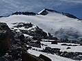
The Rheinwaldhorn / Adula 3402 m with normal route from Adulahütten over the Vadrecc di Bresciana seen from the northwest

View from the summit to the east over the Ursprung (with the young Hinterrhein), Paradies and Hinterrheintal

View from the summit to SE with the Zapporthorn and Bernina group

View from the normal route near the Adulajoch to the west, over Valle di Blenio, behind the Valais Alps

View from the upper Länta Glacier to the east, approx. 3300 m
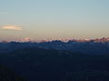
Sunrise over the Valais Alps as seen from Vadrecc di Bresciana


Web links
- Rheinwaldhorn on summitpost.org (English)
- Rheinwaldhorn on Peakbagger.com (English)
- Rheinwaldhorn at ethorama.library.ethz.ch
- Adula on biblio.unibe.ch (accessed on May 8, 2017)
Individual evidence
- ↑ Rheinwaldhorn in the Glossary of the Historical Lexicon of Switzerland
- ^ Club guide Ticino Alps 3 by Giuseppe Brenna, German edition 1996, p. 299
- ↑ Mentioned e.g. B. in Map of the Roman Empire - Alps on bible-history.com
- ^ SAC - Club Guide Bündner Alpen 2; 5th edition 1996
- ↑ Adūla . In: Meyers Konversations-Lexikon . 4th edition. Volume 1, Verlag des Bibliographisches Institut, Leipzig / Vienna 1885–1892, p. 134.
- ↑ The hand-book for travelers in Switzerland and the Alps of Savoy and Piedmont, 1811 p.90 (Google Books)
- ↑ https://map.geo.admin.ch
- ^ Research Institute for Hydraulic Engineering, Hydrology and Glaciology (VAW) of the ETH Zurich (ed.): Vadrecc di Bresciana. In: Swiss Glacier Measurement Network. ( ethz.ch , also as PDF ).
- ^ National map of Switzerland 1: 50,000 sheet 1253, edition 2001