Lepontine Alps
| Lepontine Alps | |
|---|---|
|
Lepontine Alps |
|
|
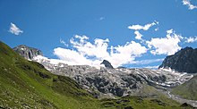
Monte Leone from the Simplon Pass |
|
| Highest peak | Monte Leone ( 3553 m above sea level ) |
| location | Regions Cantons Valais , Ticino , Graubünden (all Switzerland ), Province Verbano-Cusio-Ossola , Province Sondrio (both Italy ) |
| part of | Western alps |
| Classification according to | SOIUSA : 10 |
| Coordinates , ( CH ) | 46 ° 23 ' N , 8 ° 50' O ( 707 289 / 137838 ) |
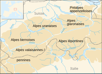
The Lepontine Alps are a mountain group in the Western Alps . They include the mountain ranges between the Simplon Pass in the west, the Splügen Pass in the east and the Northern Italian lakes in the south. The name is derived from the Leponti , a people who lived on the upper Rhone and Ticino in antiquity , whose main town was Oscellä, today's Domodossola.
Nowadays this area of the Lepontine Alps is subdivided several times. On the one hand, there is the "rough" historical subdivision, which is based on the main traffic routes, into the Ticino Alps and the Adula Alps . The dividing line is formed by the Gotthard Pass and the Leventina Valley. The third subsection after SOIUSA are the Monte Leone-Sankt Gotthard Alps , which encompass the mountains from the Monte Leone group to the Gotthard massif .
On the other hand, there is a "finer" subdivision, which is more oriented towards orographic and geological aspects, in which the northern part of the area between Nufenen Pass and Lukmanier Pass forms the Gotthard massif . Then the area of the Ticino Alps ends from Domodossola from the Valle Antigorio in a northerly direction following the Griespass and Val Bedretto . The area between Val Cadlimo and Biasca is then usually included in the Ticino Alps. The Monte Leone Group u. a. between Simplon and Nufenen falls in this view on the Valais Alps .
Limitations according to SOIUSA
- Northwest: Bernese Alps in the broader sense separated by the Rhone , Goms and Furka Pass
- Northeast: Glarus Alps in the broader sense separated by the Oberalp Pass and the Vorderrhein
- West: Valais Alps bounded by Saltina , Simplon Pass , Chrummbach, Toce
- South: here the insubric line , which roughly follows the line Centovalli - Locarno - Bellinzona - San-Jorio-Pass , separates the Lugano Prealps .
List of mountains
| Surname | height |
|---|---|
| Monte Leone | 3553 |
| Breithorn | 3438 |
| Rheinwaldhorn | 3402 |
| Güferhorn | 3393 |
| Blinnenhorn | 3384 |
| Basòdino | 3276 |
| Pizzo Tambo | 3276 |
| Helsenhorn | 3274 |
| Wasenhorn | 3255 |
| Furnace horn | 3242 |
| Shear load | 3213 |
| Piz Medel | 3203 |
| Scopí | 3200 |
| Pizzo Rotondo | 3197 |
| Piz Terri | 3151 |
| Piz Aul | 3124 |
| Pizzo Pesciora | 3120 |
| Witenwasserenstock | 3084 |
| Pizzo Campo Tencia | 3072 |
| Leckihorn | 3069 |
| Bruschghorn | 3054 |
| Alperschällihorn | 3038 |
| Chilchalphorn | 3040 |
| Piz Blas | 3023 |
| Monte Giove | 3010 |
| Pizzas d'Anarosa | 3002 |
| Pizzo Centrale | 2999 |
| Piz Beverin | 2998 |
| Weisshorn | 2992 |
| Gemsstock | 2962 |
| Pizzo Lucendro | 2963 |
| Piz Tomul | 2949 |
| Piz Cavel | 2944 |
| Barenhorn | 2932 |
| Six Madun (Badus) | 2932 |
| Piz Muraun | 2899 |
| Zervreil maple | 2898 |
| Monte Cistella | 2851 |
| I Rodond | 2829 |
| Piz Lukmanier | 2778 |
| Piz Alv | 2769 |
| Madom Gröss | 2741 |
| Monte prose | 2737 |
| Pizzo di Claro | 2727 |
| Piz de Cressim | 2575 |
| Pizzo Columbe | 2549 |
| Pizzo la Scheggia | 2466 |
| Camoghè | 2226 |
| Piz Mundaun | 2063 |
| Monte Berlinghera | 1930 |
| Monte Generoso | 1704 |
| Monte Spalavera | 1534 |
| Monte San Salvatore | 916 |
glacier
The main glaciers:
Other glaciers:
List of passports
| passport | place | Wegart | height |
|---|---|---|---|
| Zapport Pass | Hinterrhein to Malvaglia and Biasca | snow | 3079 |
| Gap | Canaltal to Lentatal (near Vals GR ) | snow | 2980 |
| Gap gap | Hinterrhein to Vals | snow | 2954 |
| Hohsandpass | Binn to La Frua (at Tosafall ) | snow | 2927 |
| Leak pass | Realp to Oberwald VS | snow | 2891 |
| Passo Rotondo | Airolo to Oberwald | snow | 2880 |
| Cold water pass | Simplon Hospice to Alpe Veglia | snow | 2844 |
| Scaradrapass | Vals to Olivone | Mountain path | 2770 |
| Saddle gap | Vals to Vrin | Mountain path | 2768 |
| Knight pass | Binn to Alpe Veglia | snow | 2692 |
| Cavanna Pass | Realp after Bedretto | snow | 2611 |
| Scatta Minoja | Devero to Formazza | Mountain path | 2597 |
| Bocca di Cadlimo | Airolo to the Lukmanier Pass | Mountain path | 2542 |
| Valserberg | Hinterrhein to Vals | Mountain path | 2507 |
| Safierberg | Splügen to Safien | Mountain path | 2490 |
| Nufenen Pass | Ulrichen to Airolo | Street | 2478 |
| Geisspfad Pass | Binn to Devero | Mountain path | 2475 |
| Griespass | Ulrichen to La Frua | Mountain path | 2468 |
| Passo di Naret | Fusio to Airolo | Mountain path | 2443 |
| Passo Valtendra | Alpe Veglia to Devero and Baceno | Mountain path | 2431 |
| Diesrutpass | Vrin to Somvix | Mountain path | 2424 |
| Tomülpass | Vals to Safien | Mule track | 2412 |
| Albrun Pass | Binn to Devero and Baceno | Mountain path | 2410 |
| Greina Pass | Olivone to Somvix | Mountain path | 2360 |
| San Giacomo Pass | Airolo to La Frua | Mountain path | 2306 |
| Passo di Buffalora | Mesocco into Val Calanca | Mountain path | 2265 |
| Passo dell'Uomo | Quinto to the Lukmanier Pass | Mountain path | 2212 |
| Splügen Pass | Thusis to Chiavenna | Street | 2117 |
| Gotthard Pass | Andermatt to Airolo | Street | 2114 |
| San Bernardino Pass | Thusis to Bellinzona | Street | 2063 |
| Lukmanier Pass | Disentis to Olivone | Street | 1917 |
literature
- Sergio Marazzi: Atlante Orografico delle Alpi. SOIUSA . Pavone Canavese (TO), Priuli & Verlucca editori, 2005. ISBN 978-88-8068-273-8 (Italian)
- Sergio Marazzi, La “Suddivisione orografica internazionale unificata del Sistema Alpino” (SOIUSA) - the complete article with detailed illustrations (pdf; 1.6 MB) (Italian)
Web links
- Lepontine Alps on the ETHorama platform


