Maighels Glacier

from Wikipedia, the free encyclopedia
Maighels Glacier
The two parts of the glacier seen from Piz Badus (2008)

The two parts of the glacier seen from Piz Badus (2008)

location Graubünden , Switzerland
Mountains Lepontine Alps
Type Slope glacier
length 1.7 km (East, 1973)
surface 1.15 km² (1973)
Exposure northwest
Altitude range 2920  m above sea level M.  -  2575  m above sea level M. (2019)
width ⌀ 0.85 km (1973)
Ice thickness ⌀ 23.2 m (east, 1973)
Ice volume 0.0255 dep1 (1973)
Coordinates 696 000  /  159 999 coordinates: 46 ° 35 '4 "  N , 8 ° 41' 28"  O ; CH1903:  696 000  /  one hundred fifty-nine thousand nine hundred and ninety-nine
Maighels Glacier (Canton of Graubünden)
Maighels Glacier
drainage Rein da Maighels , Rein da Curnera , Vorderrhein , Rhine , North Sea
particularities two tongues, now separated
Template: Infobox Glacier / Maintenance / Image description missing

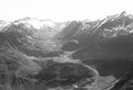
The Maighelsgletscher ( Romansh Glatscher since Maighels ) is an Alps - Glacier in the westernmost corner of the canton of Grisons in Switzerland . It is located on the northwest slope of Piz Ravetsch ( 3007  m above sea level ) and its secondary peak Piz Borel ( 2952  m above sea level ) in the rear Val Maighels in the area of ​​the municipality of Tujetsch in the Surselva .

The small glacier is divided into two parts by a ridge. About 100 years ago, however, the two parts were still connected in the lower area. The eastern part is a bit bigger and longer, compare the table below. Like all other glaciers in the region, a further, clear decline can also be seen on the Maighels glacier. However, the Maighels glacier is not continuously observed or measured.

The two glacier tongues feed the Rein da Maighels , one of the source rivers of the Vorderrhein .

The glacier can be easily reached from Tschamut  and the Maighelshütte through Val Maighels and can be skied  on touring skis in winter .

Important key figures for the two glacier tongues

Area (km²)
glacier 1850 1973 Loss 1850–1973
Eastern part 1.28 0.705 0.576
Western part 0.85 0.444 0.406
Length (km)
glacier 1850 1973 Withdrawal 1850–1973
Eastern part 2.4 1.7 0.7
Western part 1.9 1.0 0.9
Height of the glacier tongue (m)
glacier 1850 1973 Relocation 1850–1973
Eastern part 2305 2460 155
Western part 2360 2520 160
Average width (m)
glacier 1850 1973
Eastern part 530 410
Western part 450 440
Volume (estimated)
glacier 1850 (km³) 1973 (km³) Loss 1850–1973 (%)
Eastern part 0.0353 0.0164 54
Western part 0.0208 0.0091 44

Individual evidence

  1. ^ Siegfried Card ; see. [1]
  2. Andi Jacomet: Sedrun glacier comparisons 1983-2011: ade ice. In: JacoBlök. October 9, 2011, accessed February 26, 2012 .
  3. Glaciers and climate change in Graubünden. (PDF; 1.0 MB) In: Office for Forest Graubünden. January 29, 2009. Retrieved July 29, 2012 .
  4. a b c d e Max Maisch: The Graubünden glaciers. Reconstruction and evaluation of the glaciers and their changes since the high level of 1850 in the area of ​​the eastern Swiss Alps . In: Physical Geography . Vol. 33. Geographical Institute of the University of Zurich, Zurich 1992, ISBN 3-85543-229-5 .