
Maighelshütte
| Camona da Maighels - Maighelshütte SAC hut |
||
|---|---|---|
 Maighelshütte |
||
| location | Val Maighels, on the foothills of the Piz Cavradi southwest ridge, southeast from Oberalp Pass ; Canton GR CH ; Valley location: Tujetsch |
|
| Mountain range | Gotthard Group | |
| Geographical location: | 695 850 / 164549 | |
| Altitude | 2313 m above sea level M. | |
|
||
| owner | SAC - Piz Terri section | |
| Built | 1943, renovation 1969, extension 1972 | |
| Construction type | hut | |
| Usual opening times | July to mid-October, late December to early May | |
| accommodation | 0 beds, 92 camps | |
| Winter room | 14 bearings | |
| Web link | Maighelshütte | |
| Hut directory | SAC | |

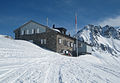
The Maighelshütte ( Romansh Camona da Maighels ) is a mountain hut belonging to the Swiss Alpine Club (SAC) in the municipality of Tujetsch in the Swiss canton of Graubünden . It is located in the Val Maighels, a side valley of the Surselva , in the Gotthard Group at 2313 m above sea level. M.
The hut offers 92 beds in several rooms and a dormitory.
history
In 1943, as part of the Reduit, the Swiss Army built the Cavradi West soldiers' barracks at today's hut location . In 1946 the Piz Terri section took over the civilian operation of the barracks renamed Maighelshütte. In 1968 the Swiss Confederation sold the hut to the Piz Terri section for 50 francs. In the summer of 1969, an 850 meter long water pipe was built and the renovation of the Maighelshütte began. In 1972 an extension was built.
Accesses
- From the Oberalp Pass in about 1½ hours.
- From Tschamut in about 2½ hours (winter access marked with poles from Alp Tschamut).
- From Andermatt via Unteralptal and Lolenpass in approx. 5½ hours.
Adjacent huts
- To the Vermigelhütte over the Maighels or Lolenpass in approx. 2½ hours.
- To the Cadlimohütte over the Bornengopass in approx. 3½ hours
- To the Treschhütte via Oberalppass and Fellilücke in approx. 5 hours.
- To the Badushütte (SAC Manegg) via Tomasee in about 1½ hours.
Tours
The area around the hut offers a variety of opportunities for hiking, alpine, climbing and bike tours (Oberalp and Maighelspass) in summer and ski tours in winter:
- Pazolastock 2739 m above sea level M. , Badus (Six Madun) 2928 m above sea level M. , Piz Cavradi 2612 m above sea level. M. , Piz Borel 2951 m above sea level. M. , Piz Ravetsch 3007 m above sea level M. , Piz Alv 2768 m above sea level. M. ,
- Maighelspass 2421 m above sea level M. , Lolenpass (Tagliola Pass) 2399 m above sea level. M. , Bornengopass 2631 m above sea level M. ,
- Lake Toma (Lai da Tuma) 2345 m above sea level M. ( source of the Rhine ),
- Reservoirs: Lai da Curnera , Lai da Nalps ,
- Piogn Crap (stone bridge), Lai Urlaun,
- Maighels Glacier .
The Maighelshütte is a stage on route 17/18 on the 38 connecting routes around the canton of Uri.
There are two climbing gardens near the hut and a well-secured climbing route at Badus ( 2928 m above sea level ).
photos

Maighelstal with hut

Hut from the west

Hüttenweg
In the winter


literature
- Sheet 1232 Oberalppass, national map 1: 25,000 (valley location Andermatt)
- Sheet 256 Disentis, national map 1: 50,000
See also
Web links
- Panorama from the Maighelshütte
- Alpine ridge routes Uri
- Official homepage of the Badushütte
- Video of ski tours starting from the Maighelshütte on Piz Borel and Piz Badus