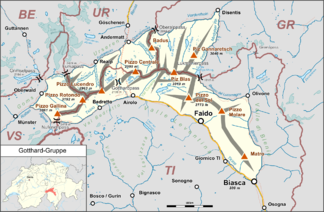
Gotthard Group
| Gotthard Group | |
|---|---|
|
In the middle of the group is the Pizzo Centrale 2999 m above sea level. M. |
|
| Highest peak | Pizzo Rotondo ( 3192 m above sea level ) |
| part of | Western alps |
| Coordinates | 695 056 / 159 409 |
| surface | 700 km² |
The Gotthard Group - also called Gotthard Mountains - is a mountain group in Switzerland in the eastern part of the Western Alps , which extends to the cantons of Uri , Graubünden , Valais and Ticino . Its highest peak is the Pizzo Rotondo , which lies southwest of the Gotthard Pass .
In the Alpine divisions according to SOIUSA and Swiss Alpine Club (SAC), the Gotthard Mountains are not regarded as an independent group and are instead assigned to various neighboring groups.
Location and area
The area is bordered (clockwise from the north) by the Oberalppass , Vorderrhein , Rein da Medel , whose left source river is Froda, Lukmanierpass , Brenno , Ticino , Nufenenpass , Ägene (also Aegina, left tributary to the Rhone ), Rotten (upper reaches of the Rhone), Furkapass , Furkareuss and Oberalpreuss and covers an area of 700 km 2 .
Groups and summits
The Gotthard Mountains are divided into the following six subgroups:
- Galina chain with the Pizzo Gallina 3061 m above sea level M.
- Rotondo chain with the Pizzo Rotondo 3192 m above sea level. M.
- Lucendro chain with the Pizzo Lucendro 2963 m above sea level. M.
- Chastelhorn -Pizzo-Centrale chain with the Pizzo Centrale 2999.3 m above sea level. M.
- Maighels Curnera-Nalps group with Piz Ganaretsch 3040 m above sea level. M. & Piz Blas 3019 m above sea level M.
- Brine group with the Pizzo del Sole 2773 m above sea level. M.
Valleys and places
In the interior of the group there are only short valleys, so the places can be found on its edge: Oberwald , Realp , Hospental , Andermatt , Biasca , Giornico , Faido , Airolo and Bedretto . At the southern end of the Leventina is its lowest point at 292 m above sea level. M. , which results in a difference to the highest of 2900 m.
Climate and water
The entire area is influenced by two climate zones: in the north by the Atlantic west wind zone and in the south by the Mediterranean climate. South of the ridge line there is less precipitation and the number of hours of sunshine is higher. The glaciers here are rather small, not to mention the general decline .
The largest part of the group, including the main peaks, belongs geologically to the Gotthard massif (further information there) , where the four rivers Rhone , Rhine ( as Rein da Tuma ) , Reuss and Ticino originate and the four-source path was laid out.
On the main Alpine ridge just a little east of the highest mountain in the group at Pt. 3025 (a secondary peak of the Witenwasserenstock ) is the watershed point between the Rhine, Rhône and Po . This is where the cantons of Uri, Ticino and Valais meet.
Images and web links
- The Gotthard Group at your mountains .
- The four source path in the Gotthard massif .
References and comments
- ↑ Mountain album based on Johannes Führer in "Bergwelt" 1980, p. 38 ff.
- ↑ a b c Ernst Höhne: Knaur's Lexicon for Mountain Friends / The Alps between Matterhorn and Lake Constance . Droemer Knaur, Munich 1987, ISBN 3-426-26223-1 , p. 124 f .

