
Oberwald VS
| VS is the abbreviation for the canton of Valais in Switzerland and is used to avoid confusion with other entries in the name Oberwald . |
| Oberwald | ||
|---|---|---|
 |
||
| State : |
|
|
| Canton : |
|
|
| District : | Goms | |
| Municipal municipality : | Obergoms | |
| Postal code : | 3999 | |
| former BFS no. : | 6066 | |
| Coordinates : | 669 809 / 153994 | |
| Height : | 1377 m above sea level M. | |
| Area : | 96.9 km² | |
| Residents: | 277 (December 31, 2007) | |
| Population density : | 3 inhabitants per km² | |
| Website: | www.oberwald.ch | |
| map | ||
|
||


Oberwald ( Valais German [ˈobərˌβɑːlt] or [ˈɔbərˌʋɑːld] ) is a place in the Valais municipality of Obergoms and a parish in the deanery of Ernen .
geography
Oberwald is the first village at the beginning of the Goms . It lies at the foot of the Furkapass and Grimsel Alpine passes . The hamlet of Gletsch , which is not inhabited all year round, and the Rhone Glacier are also located in the area of the former municipality of Oberwald .
Oberwald is the starting point for the approximately 100 kilometers of cross-country trails on the Goms trail. The car transport through the Furka tunnel begins and ends here . The inhabitants of Oberwald live mainly from tourism and cattle breeding.
history
The first documented mentions of the place are de Superiore Valde (1386), de Superiori Waldt (1402) and Oberwaldt (1419). In the past, Oberwald was just called forest .
Together with the neighboring towns of Unterwassern and Obergesteln , joint farmers' guilds formed here in the late Middle Ages, which constituted the uppermost quarter of Goms. All three villages were reduced to rubble and ashes by the Bernese during the Rarn War in 1419. The valley owned a free court from 1405 until the French Revolution and the subsequent Helvetic Republic . The free court had high and low jurisdiction.
The village of Oberwald merged with the neighboring village of Unterwassern to form the municipality of Oberwald in 1834. This was the result of the devastating flood in 1834, which exceeded the financial resources of the Unterwassern community. Unterwasser was hit by a flood as early as 1706. The place Oberwald is north of the Rotten , whereas Unterwassern is south of it.
In terms of the church, the community of Oberwald was under Münster until the first half of the 17th century and then Obergesteln. In 1719 the community received its own rectorate. Baptism rights were acquired in 1736 and burial rights in 1736. It was not until 1767 that the church in Obergesteln was separated, but Oberwald only became an independent parish in 1871.
On November 25, 2007, a referendum approved a merger of the three previously independent municipalities in Goms , Ulrichen , Obergesteln and Oberwald. The new municipality of Obergoms has existed since January 1st, 2009.
population
| Population development | |||||
|---|---|---|---|---|---|
| year | 1850 | 1900 | 1950 | 2000 | 2007 |
| Residents | 280 | 240 | 321 | 260 | 277 |
Attractions
Winter and winter sports in Oberwald
Although Oberwald is only 1366 m high, the winters are snowy here. In midwinter, Oberwald normally has the highest snow depth of all political communities in Switzerland. There is almost half a year of snow, whereby there are only about three winters per century in which a snow depth of 1 m is not reached. This means that Oberwald and the adjacent cross-country skiing area of the Goms are guaranteed to have snow.
Around 100 km of trails are groomed from Oberwald to Niederwald. In addition, both snowshoeers and ski tourers will find routes of varying degrees of difficulty ( Sidelhorn , Blashorn , Tällistock , Gross Muttenhorn ). A winter hiking trail and a snowshoe trail lead to Oberwald's local mountain, the Hungerberg . Sledging is possible from the Grimsel Pass on a 13 km long descent to Oberwald. There are 85 km of winter hiking trails for winter hikers.


View of the village from the Gommer Höhenweg

In the old village center
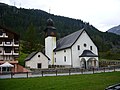
Village church

barn

old house next to the village chapel

Oberwald loading station


literature
- Robert Walpen: Oberwald. In: Historical Lexicon of Switzerland . 2017 .
- Walter Ruppen: Oberwald . In: Society for Swiss Art History (Hrsg.): Kunstdenkmäler der Schweiz (= vol. 64 ). Das Obergoms vol. 1. Birkhäuser Verlag, Basel 1976, ISBN 3-7643-0728-5 , p. 165-180 .
Web links
- Oberwald VS on the ETHorama platform
- Website of the municipality of Obergoms
- OberwaldPanorama: Information and pictures from Oberwald
Individual records
- ^ Linguistic Atlas of German-speaking Switzerland , Volume V 1b.
- ↑ Lexicon of Swiss Community Names , ed. from the Center de Dialectologie at the University of Neuchâtel under the direction of Andres Kristol, Frauenfeld / Lausanne 2005, p. 671.
- ↑ Kunstdenkmäler der Schweiz Volume 64, footnote p. 166: According to information from J. Lauber in the register of H. H. Provincial Lord of Oberwald on July 9, 1719.
Bellwald | Binn | Appoint | Fiesch | Fieschertal | Goms | Lax | Obergoms
Former parishes: Ausserbinn | Biel | Blitzingen | Geschinen | Gluringen | County | Mühlebach | Munster | Münster-Geschinen | Niederernen | Niederwald | Oberwald | Upper frames | Reckingen | Reckingen-Gluringen | Ritzingen | Selkingen | Stone house | Ulrichen
Canton of Valais | Districts of the canton of Valais | Municipalities of the canton of Valais