Pazolastock
| Pazolastock / Piz Nurschalas | ||
|---|---|---|
|
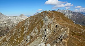
Pazolastock in the Gotthard area from the south |
||
| height | 2739 m above sea level M. | |
| location | Cantons of Uri and Graubünden , Switzerland | |
| Mountains | Gotthard Group in the Alps | |
| Dominance | 0.65 km → point 2742 | |
| Notch height | 42 m | |
| Coordinates | 693 362 / 167 007 | |
|
|
||
| Normal way | from the Oberalp Pass | |
The Pazolastock ( Rhaeto-Romanic Piz Nurschalas ) is a 2739 m high mountain in the Gotthard Group . It rises to the southwest of the Oberalp Pass ( 2044 m ).
The summit is on the border between the communities of Andermatt in the Swiss canton of Uri on its west side and Tujetsch in Graubünden on the east side. A ridge leads from the summit without major differences in altitude on the canton border to the south to point 2742, then falls to Martschallücke ( 2684 m ) and then climbs to Rossbodenstock ( 2837 m ). From point 2742 a hiking trail continues in a south-easterly direction to the Badushütte and the Tomasee .
The summit is climbed in both summer and winter. For a long time there was a Swiss Army barracks on the saddle below the summit .
Contrary to the original plans from 1886, no large artillery plant was built on the Oberalp Pass for cost reasons , but Fort Stöckli was built back . In the expansion phase from 1895 to 1910, work was carried out on the Pazolastock to protect the right flank of the pass road. This also included a path to the Pazolaalp on the western slope of the mountain. In the following decade an "infantry defense line" ( Walter Lüem ) was set up, which stretched from the Pazolastock over the opposite Calmut ( 2310 m ) to the Fellilücke ( 2476 m ). The trenches and walls on the northern slope of the Pazolastock still bear witness to this today . The Oberalppass blocking point with two infantry units at the northern foot of the Pazolastock, at the western end and in the middle of the Oberalpsee , is more recent.
literature
- Charles Knapp, Maurice Borel, Victor Attinger, Heinrich Brunner, Société neuchâteloise de géographie (editors): Geographical Lexicon of Switzerland . Volume 3: Krailigen - Plentsch . Verlag Gebrüder Attinger, Neuenburg 1905, p. 610, keyword Nurschallas (Piz) or Pazzolastock ( scan of the lexicon page ).
Web links
Individual evidence
- ↑ a b Position and altitude according to the national map of Switzerland
- ↑ Ski tour to the Pazola and Rossbodenstock. In: Railway Sports Club Lucerne. December 5, 2019, accessed February 22, 2020 .
- ↑ Walter Lüem: Fort St. Gotthard: men and arms in rock and stone . In: Max Mittler (ed.): The history of the Swiss fortifications . Orell Füssli, Zurich 1992, ISBN 3-280-01844-7 , p. 55 ff .
- ↑ Oberalp Pass. In: festung-oberland.ch. Retrieved May 11, 2020 .


