
Pizzo di Claro
| Pizzo di Claro | ||
|---|---|---|
 View from the northwest of the Leventina Valley |
||
| height | 2727 m above sea level M. | |
| location |
Limit TI GR , CH |
|
| Mountains | Adula Alps | |
| Dominance | 5.1 km → Torrone Alto | |
| Notch height | 361 m ↓ Bocchetta di Pianca Geneura | |
| Coordinates | 724.59 thousand / 128 474 | |
|
||

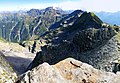
The Pizzo di Claro , also called Visagno , is 2727 m above sea level. M. the southernmost prominent panoramic mountain in the Adula Alps . Its powerful trapezoidal shape dominates the Leventina Valley and the Magadino plain .
geography
The western side of the summit of Pizzo di Claro is around 2400 meters above the village of Claro on the border of the cantons of Ticino and Graubünden in the Lepontine Alps (according to the SOIUSA classification ). There are two peaks, of which the northern one is 7 m higher than the southern one. Bellinzona and the Riviera can be seen from the south summit and Cresciano from the north summit . In the east it rises above the Graubünden Calanca valley near Arvigo . To the west of the summit is at 2198 m above sea level. M. the small lake Laghetto di Canee .
“This is the majestic mountain that every Ticino person knows and perhaps wants to climb at least once in their life”, writes Giuseppe Brenna in the Ticino Alps club guide.
Ascent and descent routes
From the Mondan car park at 1640 m above sea level. M. above Arvigo in the Calanca valley, a hiking trail leads to Alp da Stabveder 1948 m above sea level. M. From there the road is barely visible and only cairns have to unnamed pass at 2,270 meters above sea level. M. The eastern flank leads to the northern main summit and the southern secondary summit with the summit cross. The descent takes place on the same route (approx. 7 hours, difficulty level T3).
A variant is the ascent from Landarenca 1272 m above sea level. M. in the Calanca valley , which can be reached with the Selma- Landarenca cable car .
For the two-day crossing, take the Lumino - Monti di Saurù cable car, 1215 m above sea level. M. and climbs in 2 hours to the Brogoldone hut (Capanna Brogoldone) 1910 m above sea level. M. up, where you can stay overnight. From there you climb over the point 2362 m above sea level. M. southeast to the summit. The descent is towards the west over the Lago di Canee, the Alps Canee and Peurett, via Corte, Benz, Moncrino to Claro (total time approx. 9 hours, degree of difficulty T4).
A multi-day circular route at the feet of Pizzo di Claro leads from Lumino via Bellen, Monte di Giova (modern church Chiesa di Nostra Signora di Fatima ), Bellen, Brogoldone hut, Monti (Maiensätze) from Savorù (cable car to Lumino), Benedictine monastery Santa Maria Assunta (Monastero di Santa Maria, founded in 1490. It can be reached with a small cable car from the valley), along Via di Castagni to Claro (total time approx. 11 hours).
gallery
View from the summit to the north

View from the Preonzo .


Web links
- Cable car Lumino - Monti di Saurù of the Funivia Pizzo di Claro SA (Italian)
- Official website of the Capanna Brogoldone (Italian)
Individual evidence