
Medelser Glacier
| Medelser Glacier | ||
|---|---|---|
 Eastern part of the glacier with Fil Liung (left), Piz Medel (center) and Piz Uffiern (right edge of the picture) (2009) |
||
| location | Graubünden , Switzerland | |
| Mountains | Adula Alps | |
| Type | Mountain glacier (plateau glacier) | |
| length | 2.5 km (1973) | |
| surface | 5.25 km² (1973) | |
| Exposure | North | |
| Altitude range | 3180 m - 2500 m (highest point at Piz Medel) | |
| Ice thickness | ⌀ 32.6 m (1973) | |
| Ice volume | 0.16 km³ (1973) | |
| Coordinates | 712000 / 163 999 | |
|
||
| drainage | Rein da Plattas and Rein da Fuorns , both flow into Rein da Medel → Vorderrhein | |
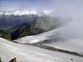
 View over the glacier to the west at an altitude of approx. 3000 meters (2008) |
||
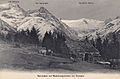
 Glatscher da Plattas on a picture postcard from around 1910 |
||

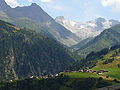
The Medelsergletscher (also Medelser glacier ; Romansh Glatscher since Medel ) is an Alps - Glacier in the Surselva in the canton of Grisons in Switzerland . It is located on the northern slope of the Piz Medel group around the Piz Medel ( 3210 m above sea level ) in the area between Val Medel , Val Sumvitg and Val Camadra . It is easily visible from Disentis . The glacier has lost a lot of its size in the last few decades.
structure
overview
The glacier stretches along the entire ridge of the massif consisting of Piz Medel and its western neighbors. It begins in the west on the eastern slope of Piz a Spescha ( 3109 m above sea level ) or northern slope of Piz Cristallina ( 3128 m above sea level ), and runs along the northern slope of Piz Uffiern ( 3151 m above sea level ), the Cima di Camadra ( 3172 m above sea level ) and Piz Medel to the western slope of Fil Liung ( 3062 m above sea level ) in the east. All these peaks rise only a little above the glacier, which - especially northeast of Piz Medel - only drops slowly in the upper part and thus reminds of a plateau glacier .
The glacier quickly becomes steeper and divides - separated by rock ridges - into several lobes and clear valleys. The Talzungen have their own names. However, the subdivision is not uniform:
- In contrast to the national map, the Medelser Glacier is not listed in the Swiss glacier inventory as a single glacier, but as three neighboring glaciers with a composite accumulation area, but their own, independent tongues.
- In the Geographical Lexicon of Switzerland and in the National Map 1: 10,000, the middle tongue is assigned to Glatscher da Plattas . In the glacier inventory it is listed as Glatscher da Medel .
Glatscher da Plattas
The Medelser Glacier once hung between the ridges of Fil Liung and Davos la Buora ( 2922 m above sea level ) or Miez Glatsche in a wide front steeply down into Val Plattas , a side valley of Val Medel. This part is called the Glatscher da Plattas and has split into two tongues due to the retreat. These eastern and middle tongues of the Medelser Glacier are separated from the large boulder Refugi da Camutschs ( 2950 m above sea level ), once a rocky island in the Arctic Ocean of the Medelscher Glacier, whose name - in English Gemsenzuflucht - is also used elsewhere for rock islands within glaciers. Today the former rock island is only surrounded by ice in the upper part.
Glacier Davos la Buora
The western tongue is the Davos la Buora glacier , which drops between Davos la Buora and Las Crunas ( 2669 m above sea level ) through Val la Buora to Val Medel , where its outflow at Fuorns flows into the Medelser Rhine . In the Meyer-Weiss Atlas (1786–1802) this part of the glacier was labeled with Wild Duck Glacier .
Smaller glaciers
To the northwest of Piz a Spescha is the rest of the small Puzzetta Glacier ( Glatscher da Puzzetta ) , which is no longer connected to the Medelser Glacier . This ice field west of the Davos la Buora and Las Crunas glaciers was still connected to the Medelser glacier 100 years ago and is still labeled Glatschè dellas Crunas on the Siegfried map .
A small ice rink can still be found on the west side of Piz Cristallina .
According to the Siegfried map , 100 years ago there were even larger glacier fields on the south side of the Piz Medel group, such as the Glatscher d'Uffiern southwest of Piz Uffiern and the Ghiacciaio di Camadra , which extends from the southern flank of the Cima di Camadra to the southern slope of Piz Medel took off. Today only the isolated hanging glacier Vadrecc di Camadra on the eastern slope of the ridge between Piz Medel and Cima di Camadra and a few smaller firn fields south of the Cima remain. A small slope glacier on the southeast flank of Piz Medel is still connected to the Medelser glacier today.
South of the Fil Liung , a tongue falls steeply over the ridge to the east into Val Lavaz to the Lavaz glacier . This glacier field used to be part of the Lavaz Glacier , which was thus directly connected to the Medelser Glacier . The hanging glacier on the eastern flank of Fil Liung , on the other hand, has recently never reached all the way down to the Lavaz glacier .
expansion

Current images show a clear decline in the glacier and that the large plateau is even breaking up into several pieces. The designation "Ice Mountains" ( Ulysses von Salis-Marschlins (1790) ) for the Piz Medel group no longer seems appropriate today.
Measurement data
The Medelser Glacier is not continuously observed or measured. The Lavaz glacier in the valley to the east is closely observed. A decline of over 700 meters has been measured here over the past 20 years. In 1973 this glacier was 2.1 kilometers long and has lost about one kilometer since then (2010).
A first large glacier inventory collected data for 1973, which was later compared with data from the glacier high level around 1850. Newer data is only available to a limited extent. The 25 glaciers in the Medel area lost a total of 41 percent of their area between 1850 and 1973.
Withdrawal from the peak in the mid-19th century until 1973
The Glatscher da Davos la Buora lost the least length in this period: this tongue is 2220 m above sea level. M. in 1850 at 2410 m above sea level. M. decreased by 500 meters. At the eastern tongue of the Glatscher da Plattas the decline was 650 meters from 2180 m above sea level. M. at 2500 m above sea level. M. The middle tongue has lost 900 meters and is 2090 m above sea level. M. at 2520 m above sea level. M. increased.
The smaller glaciers are usually no longer connected to the glacier plateau. As usual, in the Medel area and around the Piz Medel group, the smaller patches of glaciers and firn as well as the glaciers exposed to the south are particularly affected by the decline. The small Glatscher d'Uffiern on the south side of Piz Cristallina had completely disappeared as early as 1973. The glacier tongue of the Vadrecc di Camadra reached up to 2620 m above sea level in 1850 . M. before, the glacier on the southeast slope of Piz Medel at 2580 m above sea level. M.
| glacier | location | surface | length | Height of the glacier tongue | Medium width | Volume (estimated) | "Snow line" | Medium glacier height | |||||||||
|---|---|---|---|---|---|---|---|---|---|---|---|---|---|---|---|---|---|
| 1850 (km²) | 1973 (km²) | Loss 1850–1973 (%) | 1850 (km) | 1973 (km) | Retreat 1850–1973 (%) | 1850 (m) | 1973 (m) | Relocation 1850–1973 (m) | 1850 (km) | 1973 (km) | 1850 (km³) | 1973 (km³) | Loss 1850–1973 (%) | Change 1850–1973 (m) | |||
| Glatscher da Medel (W) | 712000 / 163999 | 2,737 | 2.145 | 21.6 | 3.40 | 2.50 | 26.5 | 2090 | 2520 | 430 | 0.81 | 0.86 | 0.0969 | 0.0699 | 28 | 105 | 40 |
| Glatscher da Plattas (O) | 713000 / 164999 | 1,944 | 1,536 | 27.6 | 2.80 | 2.15 | 23.2 | 2180 | 2500 | 320 | 0.77 | 0.73 | 0.0707 | 0.0460 | 35 | 145 | 75 |
| Glacier Davos la Buora | 711000 / 163999 | 2.164 | 1,567 | 21.0 | 2.50 | 2.00 | 20.0 | 2220 | 2410 | 190 | 0.78 | 0.77 | 0.0613 | 0.0448 | 27 | 80 | 35 |
| Sum Medelser Glacier | 712000 / 163999 | 6,845 | 5,248 | 23.3 | 3.40 | 2.50 | 20.0 | 2090 | 2410 | 320 | k. D. | k. D. | 0.2289 | 0.1607 | 30th | k. D. | k. D. |
| glacier | location | surface | length | Height of the glacier tongue | Medium width | Volume (estimated) | "Snow line" | Medium glacier height | |||||||||
|---|---|---|---|---|---|---|---|---|---|---|---|---|---|---|---|---|---|
| 1850 (km²) | 1973 (km²) | Loss 1850–1973 (%) | 1850 (km) | 1973 (km) | Retreat 1850–1973 (%) | 1850 (m) | 1973 (m) | Relocation 1850–1973 (m) | 1850 (km) | 1973 (km) | 1850 (km³) | 1973 (km³) | Loss 1850–1973 (%) | Change 1850–1973 (m) | |||
| Glatscher da Puzzetta | 710000 / 163699 | 0.394 | 0.261 | 33.8 | 1.10 | 0.85 | 22.7 | 2580 | 2610 | 30th | 0.36 | 0.31 | 0.0079 | 0.0048 | 39 | 25th | 15th |
| Puzetta II | 710300 / 164099 | 0.255 | 0.107 | 58.0 | 0.85 | 0.55 | 35.3 | 2560 | 2710 | 150 | 0.30 | 0.19 | 0.0046 | 0.0017 | 63 | 80 | 55 |
| Piz Cristallina (O) | 710300 / 163099 | 0.132 | 0.075 | 43.2 | 0.75 | 0.50 | 33.3 | 2740 | 2850 | 110 | 0.18 | 0.15 | 0.0021 | 0.0011 | 48 | 50 | 35 |
| Lavaz (W) | 713500 / 165499 | 0.794 | 0.301 | 62.1 | 0.95 | 0.50 | 47.4 | 2520 | 2740 | 220 | 0.84 | 0.60 | 0.0190 | 0.0057 | 70 | 140 | 120 |
| Vadrecc di Camadra | 712700 / 163499 | 0.521 | 0.199 | 61.8 | 0.95 | 0.50 | 47.4 | 2620 | 2940 | 320 | 0.55 | 0.40 | 0.0112 | 0.0034 | 70 | 170 | 105 |
| Piz Medel (SO) | 713000 / 163999 | 0.437 | 0.176 | 59.7 | 0.90 | 0.45 | 50.0 | 2580 | 2940 | 360 | 0.49 | 0.39 | 0.0090 | 0.0030 | 66 | 120 | 80 |
| Glatscher d'Uffiern | 711200 / 162599 | k. D. | 0 | disappeared | k. D. | 0 | disappeared | 2620 | k. D. | disappeared | k. D. | k. D. | k. D. | 0 | disappeared | disappeared | disappeared |
Withdrawal 1973 until today
Exact figures for the situation after 1973 were no longer published. On the other hand, pictures and occasionally published data confirm the progressive glacier retreat.
According to current maps, the longest tongue now only reaches up to around 2600 m above sea level. M. , although this should no longer be relevant. The smaller glaciers and firn fields are likely to be particularly hard hit by the decline.
The glacier forelands of the two main tongues were surveyed between 1995 and 1998 and 2003 to 2005. In this period of no more than nine years alone, 36 hectares of ice were lost at the end of the tongue (increase in glacier forelands).
Current pictures (2014) suggest that the former plateau glacier has collapsed in parts and that the accumulation area of the individual tongues is no longer connected.

Glacier foreland

The aprons of the two tongues of Glatscher Davos la Buora and Glatscher da Plattas have been floodplain areas of national importance since 2001 . A quarter and a third of the two protected areas of 101 and 170 hectares, respectively, consist of rock, mostly rock surfaces carved by the glacier. At Glatscher da Plattas there are special, round hump-like rock shapes. There are large populations of Alpen-Mannsschild , common Pohlia turf (family of the Mniaceae ), in the lower area of the Platta glacier apron with its flat moors there are seldom large areas of willowherb and near the apron of the Davos la Buora glacier large areas with dwarf shrub heaths . Forest areas are not part of the protected area.
Alpinism
The easiest way to get to the glacier is from the Medelserhütte on Fuorcla da Lavaz north of Fil Liung . The ascent is technically not too demanding. In winter it can be used as part of ski tours.

In 1782, the Benedictine priest Placidus a Spescha from the Lukmanier Pass , where he worked as a pastor, was the first to climb the Piz Cristallina . He was the first person who could see the glacier from above. The glacier was a dangerous obstacle with the equipment at that time, which is why it climbed from the west and did not implement the plan to descend over the glacier. Three years later he climbed the Piz Uffiern .
Only a few occasional inspections in the Piz Medel group have been documented for the 19th century. In 1910 the Medelserhütte was built by the SAC section Uto , which made the area more accessible for mountaineers and tourers.
photos

View from Piz Medel to the northwest of the Davos la Buora glacier (2008)
View from Piz Medel over the plateau to the northeast (2008)
The western part of the Disentis glacier (2006)
Val Plattas with glacier on a picture postcard from 1910

Piz Medel and Piz Cristallina on a picture postcard from 1912

Piz Medel massif from the north (2011)

Western part with Glatscher Davos la Buora on a picture postcard from 1910


Web links
- Photos "Glacier comparison for the years 1983, 1994 and 2011" (jacomet.ch)
Remarks
- ↑ In the definition of Maisch / Wipf / Denneler / Battaglia / Benz a mountain glacier
- ↑ In older documents ( Siegfriedkarte , Geographisches Lexikon der Schweiz, Derichsweiler) the designation Miez Glatsche resp. Miez Glatsché . In the current national map, however, the mountain range is labeled Davos la Buora .
- ^ Fritz Müller , Toni Caflisch and Gerhard Müller: Firn and ice in the Swiss Alps. Glacier inventory . Ed .: ETH Zurich. Publication No. 57 of the Geographical Institute of the ETH. Zurich 1976.
- ↑ a b Marked in the glacier inventory as Glatscher da Medel-W (A14G / 02), the western tongue of the Glatscher da Plattas , which is marked in the glacier inventory as Glatscher da Plattas-E (A14G / 16n).
- ↑ a b 2: 1 equilibrium line: altitude AAR value 0.67
- ↑ a b 1: 1 line: Altitude AAR value 0.50
Individual evidence
- ^ Charles Knapp, Maurice Borel, Victor Attinger, Heinrich Brunner, Société neuchâteloise de geographie (editor): Geographical Lexicon of Switzerland . Volume 3: Krailigen - Plentsch . Verlag Gebrüder Attinger, Neuenburg 1905, p. 324, keyword Medel (Piz), Medelserthal ( scan of the lexicon page ).
- ^ A b Charles Knapp, Maurice Borel, Victor Attinger, Heinrich Brunner, Société neuchâteloise de geographie (editor): Geographical Lexicon of Switzerland . Volume 3: Krailigen - Plentsch . Verlag Gebrüder Attinger, Neuenburg 1905, p. 323 f., Keyword Medel (Glatsché) ( scan of the lexicon page ).
- ↑ a b Federal Office of Topography swisstopo: National map of Switzerland 1.50 000 - sheet 256 S Skitourenkarte Disentis / Mustér . Wabern 2009
- ↑ a b c d e f g Max Maisch: The Graubünden glaciers. Reconstruction and evaluation of the glaciers and their changes since the high level of 1850 in the area of the eastern Swiss Alps . In: Physical Geography . Vol. 33. Geographical Institute of the University of Zurich, Zurich 1992, ISBN 3-85543-229-5 .
- ^ A b c Charles Knapp, Maurice Borel, Victor Attinger, Heinrich Brunner, Société neuchâteloise de geographie (editor): Geographical Lexicon of Switzerland . Volume 3: Krailigen - Plentsch . Verlag Gebrüder Attinger, Neuenburg 1905, p. 764, keyword Plattas (Glatsché de) ( scan of the lexicon page ).
- ↑ Federal Office for Topography swisstopo: National map of Switzerland 1.10 000 : Swisstopo geodata
- ^ Charles Knapp, Maurice Borel, Victor Attinger, Heinrich Brunner, Société neuchâteloise de geographie (editor): Geographical Lexicon of Switzerland . Volume 4: Plessur - Switzerland . Verlag Gebrüder Attinger, Neuenburg 1906, p. 189, keyword Rifugi Camotsch ( scan of the lexicon page ).
- ^ Charles Knapp, Maurice Borel, Victor Attinger, Heinrich Brunner, Société neuchâteloise de geographie (editor): Geographical Lexicon of Switzerland . Volume 1: Aa - Emmengruppe . Verlag Gebrüder Attinger, Neuenburg 1902, p. 391, keyword Buora (Glatsché Davos la) ( scan of the lexicon page ).
- ↑ a b c d Walram Derichsweiler: The Medelser Mountains . In: Yearbook of the Swiss Alpine Club 1909-1910 . 45th year. Verlag der Expedition des Jahresbuch des SAC, Bern 1910, p. 107 ( reference on the SAC website ). Reference on the SAC website ( Memento from September 5, 2016 in the Internet Archive )
- ^ Charles Knapp, Maurice Borel, Victor Attinger, Heinrich Brunner, Société neuchâteloise de geographie (editor): Geographical Lexicon of Switzerland . Volume 1: Aa - Emmengruppe . Verlag Gebrüder Attinger, Neuenburg 1902, p. 576, keyword Crunas (Las) and Glatsché dellas Crunas ( scan of the lexicon page ).
- ↑ a b c Siegfried Card. Retrieved February 29, 2012 .
- ↑ a b Andi Jacomet: Sedrun Glacier Comparisons 1983-2011: Ade ice. In: JacoBlök. October 9, 2011, accessed February 26, 2012 .
- ↑ Glaciers and climate change in Graubünden. (PDF; 1.0 MB) In: Office for Forest Graubünden. January 2009, accessed 29 February 2012 .
- ↑ Glacier Reports (1881–2009) “The Glaciers of the Swiss Alps” . In: Research Institute for Hydraulic Engineering, Hydrology and Glaciology [VAW] of the ETH Zurich (Ed.): Yearbooks of the Expert Commission for Cryosphere Measurement Networks of the Swiss Academy of Sciences [SCNAT] . No. 1–126 ( glaciology.ethz.ch [PDF; 149 kB ]).
- ^ A b Max Maisch, Andreas Wipf, Bernhard Denneler, Julius Battaglia, Christof Benz: The glaciers of the Swiss Alps - glacier high level 1850, current glaciation, glacier retreat scenarios . Final report NFP 31. vdf Hochschulverlag AG at the ETH Zurich, Zurich 1999, ISBN 3-7281-2568-7 .
- ↑ Max Maisch: Glacier retreat in the period of the outgoing late glacial (Egesen stage) and since the high level of 1850 as well as forecasts for the future ice retreat in the Alps . In: Swiss Academy of Sciences. Glacier Commission (Ed.): Glaciers in constant change: Jubilee symposium of the Swiss Glacier Commission, 1993 Verbier (VS): "100 Years of the Glacier Commission - 100,000 years of glacier history" . tape 6 of publications by the Swiss Academy of Sciences. vdf Hochschulverlag AG, Zurich 1995, ISBN 3-7281-2208-4 , p. 81-100 ( books.google.ch ).
- ↑ Cristian Scapozza: Contribution à l'étude et géomorphologique géophysique of environnemnts périglaciaires des Alpes Tessinoises orientales . Lausanne February 2008 ( mesoscaphe.unil.ch [PDF]).
- ↑ further image comparisons
- ^ A b c Peter Gsteiger, Mary Leibundgut, Antonio Righetti: First survey of alpine floodplains - canton report "Results of the Canton of Graubünden" . Ed .: Federal Office for the Environment. Bern January 2006 ( bafu.admin.ch [PDF; accessed on June 8, 2017]).
- ↑ File: Panorama Piz Medel Massiv.JPG
- ↑ Ordinance on the protection of alluvial areas of national importance (Auenverordnung) of October 28, 1992 (as of January 1, 2008) (PDF; 523 kB)
- ↑ Peter Gsteiger, Mary Leibundgut, Antonio Righetti: first recording alpine floodplains - final report . Ed .: Federal Office for the Environment. Bern January 2006 ( bafu.admin.ch [PDF; accessed on June 8, 2017]).
- ↑ Piz Medel, 3210m. In: Medelser Hütte. Retrieved February 27, 2012 .
- ↑ Piz Medel. In: SummitPost. Retrieved February 27, 2012 .
- ↑ Piz Medel alpine tour. In: bergfuehrer-sedrun.ch. Retrieved February 17, 2012 .
- ↑ R. Ebner: Surselva - on the trail of the strange monk. (PDF) Retrieved February 27, 2012 .