
Val Medel
| Val Medel | ||
|---|---|---|
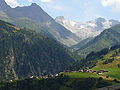
 Val Medel near Platta |
||
| location | Graubünden , Switzerland | |
| Waters |
Rein da Medel Lai da Sontga Maria Medelsergletscher |
|
| Mountains |
Piz Rondadura (3016 m) Piz Gannaretsch (3039 m) Piz Gierm (2940 m) Piz Vatgira (2982 m) Piz Scopí (3189 m) Piz Cristallina (3128 m) Piz Medel (3210 m) |
|
| Geographical location | 706 795 / 165 624 | |
|
||
| height | 1050 to 3189 m above sea level M. | |
| length | 15 km | |
| particularities | Lukmanier Pass 1,915 m above sea level M. | |

The Val Medel ( ) is a right side valley of the Surselva in the Swiss canton of Graubünden . It stretches for about 15 km from Disentis / Mustér ( 1100 m above sea level ) in a southerly direction to Lai da Sontga Maria on the Lukmanier Pass ( 1906 m ). The road leads through the valley to the Lukmanier Pass and further into Ticino .
In the bottom three kilometers, the valley forms a narrow gorge, the "Medelserschlucht" or "Las Ruinas", which widens into a green and fertile trough valley near the village of Curaglia.
Settlements

The only municipality in the valley is Medel (Lucmagn) , which includes numerous villages, hamlets and isolated settlements on both sides of the valley. The largest and northernmost village is Curaglia. Other settlements are (from north to south) Mutschnengia, Platta, Pardè, Fuorns and Acla. The entire municipality extends over 136 km², of which 90 km² are unproductive area.
Language and religion
Sursilvan is spoken in Val Medel, a mixture of the dialects of Disentis and the Tuachin spoken in Tujetsch . The vast majority of the population is Catholic.
Waters

The most important river in the valley is the Rein da Medel . In the upper section of the valley below the Lai da Sontga Maria reservoir , it is called Froda . After the union with the Rein da Cristallina , which drains the Val Cristallina , near the hamlet of Pardatsch (1559 m) it is called Rein da Medel . On the way it takes in numerous other streams from both sides of the valley. In the lowest section of the valley, the river passes the Medelserschlucht Las Ruinas and then flows south of Disentis into the Vorderrhein .
The extensive glacier field of the Medelser glacier lies on the massif around the Piz Medel .
Side valleys
At Curaglia the Val Plattas flows into the Val Medel from the southeast, and the Val Cristallina from the hamlet of Pardatsch also from the southeast.
The source valleys of the Rein da Medel, the Val Cadlimo and the Val Datum in the canton of Ticino are not counted as part of the Val Medel.
photos
Mumpé Medel in the foreground, behind the Medelserschlucht, in the background the Piz Medel and the Medelsergletscher

Southern part near Sogn Gagl


Web links
- Official website of the municipality of Medel (Lucmagn)
- Val Medel
- Adolf Collenberg: Medel (Lucmagn). In: Historical Lexicon of Switzerland .
- Val Medel on the ETHorama platform
Individual evidence
- ^ A b Charles Knapp, Maurice Borel, Victor Attinger, Heinrich Brunner, Société neuchâteloise de geographie (editor): Geographical Lexicon of Switzerland . Volume 3: Krailigen - Plentsch . Verlag Gebrüder Attinger, Neuenburg 1905, p. 324 f., Keyword Medelserthal ( scan of the lexicon page ).