
Piz Medel
| Piz Medel | ||
|---|---|---|
 Piz Medel (center) and Glatscher da Medel / da Plattas (left) |
||
| height | 3210 m above sea level M. | |
| location | Canton border Ticino / Graubünden , Switzerland | |
| Mountains | Adula Alps | |
| Dominance | 15.3 km → Grauhorn | |
| Notch height | 942 m ↓ Crap la Crusch | |
| Coordinates | 712 781 / 164066 | |
| Topo map | Swisstopo 1: 25000 sheet 1233 Greina | |
|
||
| First ascent | June 9, 1865 by Fr. Deplaci, Baptist Monn and Fr. Störi | |
| Normal way | Camona da Medel - Glatscher da Medel, L, 2.5h | |

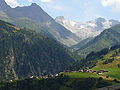
The Piz Medel is a 3210 m above sea level. M. high mountain in the Adula Alps in Switzerland . It is the highest peak of the Piz Medel group , which runs in a west-east direction , a chain of three thousand meter peaks that stretches from Piz Cristallina in the west to Fil Liung in the east and only slightly towers above the glacier area of the Glatscher da Medel . This chain of peaks forms the border between the cantons of Ticino and Graubünden . The northern part of Graubünden belongs to the municipality of Medel (Lucmagn) , the southern part of Ticino belongs to the municipality of Blenio .
meaning
Piz Medel is a popular tour destination in winter and summer and can be easily reached from several huts ( Capanna Scaletta , Capanna Motterascio , Camona da Terri , Camona da Medel ). Since 2010, on the initiative of mountain guide David Berther from Disentis, there has been a summit cross with a summit book on Piz Medel.
Surname
The name is said to go back to the Greek metallion and to have something to do with earlier mining activities in the Val Medel.
geology
Geologically, the group of peaks around Piz Medel belongs to the Gotthard massif, which north of the Greina consists mainly of so-called old crystalline metamorphic rocks. The Piz Medel itself is made up of Augengneisen.
glacier
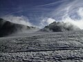
To the northwest of the summit lies the Medelsergletscher (Glatscher da Medel) . This glacier field, which stretches from Fil Liung to Piz Cristallina in a width of about three kilometers, is one of the large glacier fields in the Graubünden Alps. The individual lobes, which are separated by the lower peaks Refugi da Camutschs and Piz la Buora at approx. 2800 m, are called Glatscher da Plattas (east and middle lobes ) and Glatscher Davos la Buora (west lobes). There is also a small glacier field on the southern flank, the runoff of which is considered the source of the Brenno .
National park
The Piz Medel is to become part of the planned Parc Adula . The summit would be part of the park's core zone.
First ascent
The first ascent took place on June 9, 1865 via Fil Liung by Ms. Deplaci, Baptist Monn and Ms. Störi. This route is not used today because of the fragile rock on Fil Liung.
Main routes
- Camona da Medel - Glatscher da Medel (normal route, L, 2.5h)
- Capanna Scaletta - Fuorcla sura da Lavaz - East Ridge (L, 3.5h)
- Further routes, mostly with character WS, in the SAC club guide Bündner Alpen 2.
photos
Piz Medel (back right) and Fil Liung (hl) from Acletta

Piz Medel massif from the north
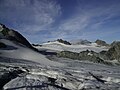
On the Glatscher da Medel, approx. 3000 m
View to the Fil Liung


Web links
Individual evidence
- ↑ Swisstopo ; In older maps and the SAC club guide, however, the altitude is given as 3211 m
- ^ National map of Switzerland 1: 25000 sheet 1233 Greina
- ^ Charles Knapp, Maurice Borel, Victor Attinger, Heinrich Brunner, Société neuchâteloise de geographie (editor): Geographical Lexicon of Switzerland . Volume 3: Krailigen - Plentsch . Verlag Gebrüder Attinger, Neuenburg 1905, p. 324, keyword Medel (Piz) ( scan of the lexicon page ).
- ↑ a b c SAC Club Guide Bündner Alpen 2, 5th edition 1996, p. 101.
- ↑ SAC Club Guide Bündner Alpen 2, 5th edition 1996, p. 40.
- ↑ Parc Adula: National Park Project (map) ( Memento of the original from January 18, 2016 in the Internet Archive ) Info: The archive link was inserted automatically and has not yet been checked. Please check the original and archive link according to the instructions and then remove this notice. , accessed on January 18, 2016 (PDF; 9.69 MB)
- ↑ Richard Goedeke: 3000er in the Western Alps , Bruckmann, 2005, ISBN 3-7654-4149-X , p. 22.