Scopí
| Scopí | ||
|---|---|---|
|
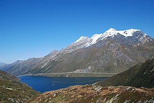
The Scopí (second from right) seen from the southwest, in front of it the Lai da Sontga Maria reservoir |
||
| height | 3190 m above sea level M. | |
| location | Canton border Ticino / Graubünden , Switzerland | |
| Mountains | Adula Alps | |
| Dominance | 8 km → Piz Medel | |
| Notch height | 792 m ↓ Cristallina Pass | |
| Coordinates | 706 657 / 158 771 | |
|
|
||
| rock | Gray and black Bündner slate | |
| Age of the rock | Lias | |
| First ascent | Placidus a Spescha , 1782 | |
The Scopí is a 3189.9 m above sea level. M. high mountain in the Adula Alps , immediately east of the Lukmanier Pass . The border between the canton of Ticino and the canton of Graubünden runs from the pass over the western ridge of the Scopí and further from the summit over the main ridge in a southerly direction. The Grisons part belongs to the municipality of Medel (Lucmagn) , the Ticino part to the municipality of Blenio . To the west lies the Val Medel with the Lai da Sontga Maria , to the east the Val Casatscha . On the north-south running ridge rises the Piz Miez to the north and the Pizzo del Corvo to the south .
There is a military radar station on the summit , which is accessed by a cable car that cannot be used by the public. During the construction of the facilities, the summit, originally nine meters higher, was leveled. The summit plateau is not a restricted area, but usually accessible to alpinists.
In 1782 the Benedictine priest Placidus a Spescha from the Lukmanier Pass , where he worked as a pastor, was the first to climb the mountain.
Web links
- Scopí on ethorama.library.ethz.ch/de/node
- Panorama from the Scopí summit on alpen-panoramen.de
Individual evidence
- ^ A b Charles Knapp, Maurice Borel, Victor Attinger, Heinrich Brunner, Société neuchâteloise de geographie (editor): Geographical Lexicon of Switzerland . Volume 5: Switzerland - Tavetsch . Verlag Gebrüder Attinger, Neuenburg 1908, p. 462, keyword Scopi ( scan of the lexicon page ).
- ↑ Swisstopo Map 256 Disentis 1985 edition.
- ^ Richard Goedeke 3000er in the Western Alps Bruckmann 2005, ISBN 3-7654-4149-X , p. 23.
- ↑ R. Ebner: Surselva - on the trail of the strange monk. (PDF) Retrieved February 6, 2016 .

