
In there Medel
| In there Medel | ||
 Lower reaches of the Rein da Medel near Pardé |
||
| Data | ||
| Water code | CH : 575 | |
| location | Switzerland | |
| River system | Rhine | |
| Drain over | Vorderrhein → Rhine → North Sea | |
| source | in Lago Scuro 46 ° 33 ′ 52 ″ N , 8 ° 41 ′ 57 ″ E |
|
| Source height | 2450 m above sea level M. | |
| muzzle | near Disentis / Mustér in the Vorderrhein Coordinates: 46 ° 41 ′ 46 ″ N , 8 ° 51 ′ 18 ″ E ; CH1903: 708 334 / 172 618 46 ° 41 '46 " N , 8 ° 51' 18" O |
|
| Mouth height | 1075 m above sea level M. | |
| Height difference | 1375 m | |
| Bottom slope | about 54 ‰ | |
| length | about 25.4 km | |
| Catchment area | 126.66 km² | |
| Discharge at the mouth of the A Eo : 126.66 km² |
MQ Mq |
5.47 m³ / s 43.2 l / (s km²) |
| Right tributaries | Rein there Cristallina | |
| Flowing lakes | Lago dell'Isra | |
| Reservoirs flowed through | Lai da Sontga Maria | |
| Communities | Quinto , Blenio , Medel , Disentis / Mustér | |
|
Tributaries and hydraulic structures
|
||||||||||||||||||||||||||||||||||||||||||||||||||||||||||||||||||||||||||||||||||||||||||||||||||||||||||||
The Rein da Medel ( Italian Reno di Medel , German Medelser Rhein ) is the longest source river of the Rhine . The river is located in the Swiss cantons of Ticino and Graubünden and flows through the Val Cadlimo and Val Medel valleys . Rein da Medel is the local Sursylvanian , i.e. Rhaeto-Romanic name in Graubünden, which is generally used for the entire river. The term Middle Rhine can also be found in older texts .
The river name has two meanings regardless of the language form: On the one hand, it is the name of the entire river. On the other hand, it is a special name for the section of the river in the Italian-speaking area - in Ticino (Italian Reno di Medel , especially the upper course of the river), as well as the lower course in the Sursilvanian language area ( Sursilv. Rein da Medel) . The Sursylvanian part of the middle reaches is called Froda .
The most important places on the river are the fractions Curaglia and Platta of the municipality of Medel .
River course
The upper reaches of the Medelser Rhine flows through Val Cadlimo, south of the main Alpine ridge, which belongs to the Ticino community of Quinto . There the river is called Reno di Medel in Italian . There are three source streams of roughly equal strength:
- a northern source stream (approx. 640 meters) - rises from several sources below the Piz Curnera
- a middle spring stream (approx. 1150 meters) - rises at the Botta di Cadlimo ( 2534 m above sea level ) and flows through the Lago di Dentro ( 2506 m above sea level )
- a southern source stream (approx. 950 meters) - rises at the Bassa del Lago Scuro below the Punta Negra and flows through the Lago Scuro ( 2451 m above sea level )
The north and middle arm of the spring merge shortly before at approx. 2390 m above sea level. M. the southern, most water-bearing, joins it. (46.6 ° N, 8.7 ° E) .
About one kilometer after these source streams meet, the Reno di Medel flows through the Lago dell'Isra ( 2322 m above sea level ). A cleft under which the Gotthard Base Tunnel NEAT runs marks the transition from Val Cadlimo to Val Medel. Shortly below the Klus, a tributary from the Passo dell'Uomo flows from the south of the Val dates . In this area, the Reno di Medel represents the border river between the municipalities of Quinto and Blenio for about 500 meters . A few meters north of the confluence with the Lai da Sontga Maria reservoir ( 1908 m above sea level ) the canton border runs between Ticino and Graubünden ( as a straight line between Lukmanierpass and Pizzo Scai, ignoring the topographical conditions ).
In Graubünden the river is located in the Sursilvan-speaking , i.e. Rhaeto-Romanic, part of the canton. The middle course is called Froda , the lower course Rein da Medel . The name change takes place at the confluence of the largest tributary Rein da Cristallina . The middle and lower reaches flow through the Val Medel and are almost predominantly in the area of the municipality of Medel; only about the last 1000 meters in the area of the Disentis / Mustér municipality , the uppermost section of the middle reaches still in Ticino.
The Lai da Sontga Maria covers the confluence of the valley leading southeast to the Lukmanier Pass. Numerous tributaries and streams flow into the entire Val Medel. The last two kilometers or so are characterized by the "Las Ruinas" ("Medelserschlucht") gorge, in which at about 1075 m above sea level. M. the Rein da Medel flows together with the Vorderrhein. Shortly above the confluence, a bridge leads Lukmanierstrasse over the Vorderrhein.
Flow lengths
The total length of the river Rein da Medel is around 25.4 kilometers. The following details for the sections of the river are also approximate and in kilometers:
- southern source stream: 0.99
- western source stream: 1.00
- northern source stream: 0.64
- Reno di Medel (upper reaches in Val Cadlimo, plus Ticino part of the middle reaches, without Lai da S. Maria): 6.76
- Lai da Sontga Maria: 2.67
- Froda (Bündner part of the middle course without Lai da S. Maria): 5.91
- Rein da Medel (lower reaches): 9.05
Neighboring river basins
The most important neighboring river basins in the Rhenish system are those of Rein Anteriur (Vorderrhein), Rein da Nalps and Rein da Sumvitg, and in the catchment area of the Po the river basins of Canaria , Murinascia Grande and Brenno .
The Rein da Medel is the only river that drains the canton of Ticino over the Rhine into the North Sea. However, a significant proportion of the water in the upper reaches of Stabbio Nuovo is captured and fed through a tunnel at Passo dell'Uomo to Murinascia Grande , a tributary of Lago Ritóm . Thus the Val Cadlimo , although orographically assigned to the Rhine, is ultimately largely drained into the Mediterranean like almost all other valleys in Ticino .
bridges
Web links
- Rein da Medel on the ETHorama platform
photos

View over the Lai da Sontga Maria to the south: on the far right the entrance to the Klus to Val Cadlimo (upper course), on the right (view into the valley) the Val appointments towards Passo dell 'Uomo, on the left the valley to the Lukmanier Pass
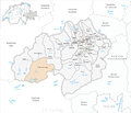
Area of the municipality of Medel with insufficiently mapped Rein da Medel

Borderline in the area of the canton border (Olivone now belongs to Blenio ). The creek that is labeled Murinascia Grande actually has a different name. The Murinascia flows south over the Lago Ritóm into the Ticino.

Middle reaches (Froda), looking north

View over the lower reaches of the Rein da Medel to the north. In the foreground Platta, in the background Curaglia. It is very clearly visible how the Rein da Medel has eroded a gorge in the U-shaped trough valley

Dam of the Lai da Sontga Maria

_2007.png)


Individual evidence
- ↑ a b Geoserver of the Swiss Federal Administration ( information )
- ↑ a b Modeled mean annual discharge. In: Topographical catchment areas of Swiss waters: sub-catchment areas 2 km². Retrieved August 30, 2017 .
- ↑ For example from the cantonal and federal offices.
- ^ Charles Knapp, Maurice Borel, Victor Attinger, Heinrich Brunner, Société neuchâteloise de geographie (editor): Geographical Lexicon of Switzerland . Volume 3: Krailigen - Plentsch . Verlag Gebrüder Attinger, Neuenburg 1905, p. 324, keyword Medelserrhein ( scan of the lexicon page ).