
Quinto TI
| TI is the abbreviation for the canton of Ticino in Switzerland and is used to avoid confusion with other entries of the name Quinto . |
| Quinto | |
|---|---|
 |
|
| State : |
|
| Canton : |
|
| District : | Leventina district |
| Circle : | Quinto County |
| BFS no. : | 5079 |
| Postal code : | 6777 |
| Coordinates : | 697 174 / 152750 |
| Height : | 1011 m above sea level M. |
| Height range : | 946-3015 m above sea level M. |
| Area : | 75.21 km² |
| Residents: | 1026 (December 31, 2018) |
| Population density : | 14 inhabitants per km² |
| Website: | www.tiquinto.ch |
 Quinto TI |
|
| Location of the municipality | |
  |
|
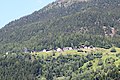
Quinto (German outdated: Quint im Livinental ) is a municipality in the Leventina district of the canton of Ticino in Switzerland . The villages of Ambrì , Piotta , Scruengo, Varenzo, Ronco, Deggio, Catto, Lurengo and Altanca belong to Quinto.
geography
The village of Quinto is located a little above the valley floor on the left slope of the Valle Leventina at 1011 meters. Most of the population of the municipality of Quinto now lives in the villages of Ambrì and Piotta on the valley floor on the right side of the valley.
On the left side of the valley on sunny terraces lie the villages of Altanca, Ronco (Quinto), Deggio, San Martino, Catto and Lurengo, which also belong to the municipality of Quinto, crossed by the Strada Alta . However, these villages are for the most part almost depopulated and only have a few inhabitants, mostly senior citizens and mountain farmers. During the summer months, life returns to the small hamlets of Quinto on the mountain, because the old houses are mainly used as holiday apartments. The municipality also includes the villages of Scruengo and Varenzo, which, like the village of Quinto itself, lie on the left bank of the Ticino river .
Quinto forms the district of Quinto together with the municipalities of Prato (Leventina) and Dalpe .
Most of the Val Cadlimo , which represents the upper reaches of the Medelser Rhine , also belongs to the municipality of Quinto . Thus, Quinto, in addition to the neighboring community Blenio to which a small piece of Val Cadlimo at the south end of the da Lai Sontga Maria belongs and Airolo with a share of the upper reaches of the Reuss , the only community in Ticino, the share of the catchment area of the Rhine has .
Neighboring communities are Airolo , Faido , Lavizzara , Blenio as well as Tujetsch and Medel (Lucmagn) in the canton of Graubünden .
Climate table
| Quinto TI (Piotta), 1981-2010 | ||||||||||||||||||||||||||||||||||||||||||||||||
|---|---|---|---|---|---|---|---|---|---|---|---|---|---|---|---|---|---|---|---|---|---|---|---|---|---|---|---|---|---|---|---|---|---|---|---|---|---|---|---|---|---|---|---|---|---|---|---|---|
| Climate diagram | ||||||||||||||||||||||||||||||||||||||||||||||||
| ||||||||||||||||||||||||||||||||||||||||||||||||
|
Average monthly temperatures and rainfall for Quinto TI (Piotta), 1981–2010
Source:
|
||||||||||||||||||||||||||||||||||||||||||||||||||||||||||||||||||||||||||||||||||||||||||||||||||||||||||||||||||||||||||||||||||||||||||||||||||||||
history
The village was first mentioned in 1227 as Quinto . As early as 1311, the guild of packers was mentioned in Quinto. The former vicinìa was divided into several degagne ; those from 1408 have been preserved.
The village belonged to the rodarìa Intus Montem (1371). As early as 1311, the guild of the mules was named in Quinto; they were distributed to degagne according to a list that was changed every three years and had a monopoly on the transport of goods. The former great vicinìa still exists today and includes the patriziati Catto, Lurengo, Piotta, Varenzo, Altanca, Ronco, Deggio, Ambrì-Sopra, Ambri-Sotto, Quinto and Quattro terre, which have replaced the earlier degagne.
When the confederates descended into the Leventina for the first time in 1331, Quinto was plundered and cremated. Fourteen soldiers died in the battle of Marignano . Under the rule of the Uri , the village was the seat of a court of appeal for the upper deed. In 1799 the uprising against the French and the Helvetic Republic started from Quinto ; the residents seized General Claude-Jacques Lecourbe's luggage , for which the community was given a severe fine and their church and several houses were plundered by the French troops.
population
| Population development | |||||||||||||
|---|---|---|---|---|---|---|---|---|---|---|---|---|---|
| year | 1639 | 1745 | 1850 | 1900 | 1950 | 1970 | 1980 | 1990 | 2000 | 2010 | 2012 | 2014 | 2018 |
| Residents | 608 | 1099 | 1382 | 1221 | 1245 | 1490 | 1391 | 1118 | 1057 | 1006 | 991 | 1077 | 1026 |
traffic
The Gotthard Pass route has run through what is now the municipality of Quinto since Roman times . However, the route only became important from 1220, thanks to the conquest of the Schöllenen in the north of the pass.
Even today's main road 2 and since 1980 the Highway A2 cross the municipality. The highway is covered at the village of Quinto. The Quinto motorway junction is on the eastern edge of the community.
In addition, the Gotthard Railway runs through the municipality, with the Ambrì-Piotta stop. While 9 of the 14 trains stopped at the station in 1882, no express trains stopped between the 1980s and December 10, 2016, and regional trains only stopped twice a day. Buses operate for local traffic.
At the level before Ambri Piotta and since is the Second World War the Ambri Airport . It was used by the Swiss Air Force until 1994 , after which it was used for civil purposes. The valley station of the Ritom funicular , which connects the valley floor with the alpine and hiking area Val Piora , is in Piotta .
Alpine areas
In the Val Piora there is the Lago Ritóm reservoir and numerous mountain lakes, for example the Lago di Cadagno , the Lago di Tom or the Laghetti di Taneda. Also rich in mountain lakes is Val Cadlimo (Lago Scuro, Lago dell'Isra and others) , which belongs to the municipality, but is on the north side of the Alps . The University of Zurich , the University of Geneva and the Canton of Ticino operate a research station for Alpine biology on Lake Cadagno. A cheese of the same name is produced on Alp Piora.
Ventures
- SBB power station near Piotta
Sports
Ambrì and Piotta are known nationally thanks to their ice hockey club HC Ambrì-Piotta (HCAP), founded in 1937 and playing in the National League A. The Pista la Valascia stadium has a capacity of 7,000 spectators.
Attractions
The village image is classified in the inventory of protected sites in Switzerland (ISOS) as a site of national importance in Switzerland.
- Parish church of Santi Pietro and Paolo with main altar by the sculptors Carlo Giuseppe Zezio and Paolo Antonio Pisoni
- In the district of Ambrì Sopra: Church of Santi Maccabei
- In the district of Piotta: Church of San Carlo
- Sanatorio Popolare Cantonale di Piotta near Altanca
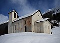
- In the Deggio district: Church of Sante Caterina and Barbara
- In the Deggio district: Chapel of San Martino
- In the district of Catto: Church of Sant'Ambrogio
- In the Altanca district: Church of Santi Carnelio and Cipriano
- In the district of Monte Aval, large rock with drawings and inscriptions dug in (1647 m above sea level)
Personalities
- Antonio Bandera (* around 1515 in Airolo ?; † after 1572 in Giornico ?), Priest, pastor in Quinto, mentioned in Giornico in 1572 as a visitor or vicar general of Charles Borromeo for the three Ambrosian valleys
- Francesco Antonio Zeglio (born October 11, 1758 in Ambrì (municipality of Quinto), † January 24, 1818 in Osogna ), member of the Swiss Grand Council, Ticino Grand Council and Small Council
- Severino Guscetti (1816–1871), politician, Ticino Grand Councilor, National Councilor and State Councilor.
- Celio family
- Enrico Celio (1889–1980), politician
- Nello Celio (1914–1995), politician
- Bixio Celio (1928–1983), hockey player, lawyer, politician
- Teco Celio (* 1952) son of Nello, actor
- Franco Celio (born April 21, 1953 in Faido), secondary school teacher, historian, politician (FDP. The Liberals), 2000–2016 Ticino Grand Councilor
- Alina Borioli (1887–1965), teacher, poet
- René Juri (born June 22, 1922 in Ambrì (municipality of Quinto); † November 24, 2003 in Le Mont-sur-Lausanne ), agricultural engineer at ETH Zurich , co-founder of HC Ambrì-Piotta , major in the Swiss Army
- Norman Gobbi (* 1977 in Faido ), politician, State Councilor.
photos

Varenzo

Deggio above Quinto
Ronco above Quinto

Altanca

Altanca and Ritom environments

Leventina with Ambri-Piotta by Eduard Spelterini , around 1900

Alm Giof

Alm Giof

Ritom cable car
San Martino

Lake Cadagno and Lake Ritom

Tomsee

The Lago Scuro


.jpg)


.jpg)
.jpg)

literature
- Piero Bianconi , Arminio Janner: Altanca , Catto , Lurengo , Deggio , Ronco , Varenzo and Quinto. In: Arte in Leventina. Istituto Editoriale Ticinese, Bellinzona 1939, pp. 20, 33, 34, 36, 38, 39, 41, 42, 44, 45, 49, 52, 65, 72, 88, 89, 90, 96, 97, 98; same: Quinto. In: Inventario delle cose d'arte e di antichità. I, Grassi & Co, Bellinzona 1948, pp. 179, 185-187, 189.
- Franco Binda: Il mistero delle incisioni. Armando Dadò editore, Locarno 2013, ISBN 978-88-8281-353-6 .
- Siro Borrani : Il Ticino Sacro. Memorie Religose della Svizzera Italiana raccolte dal sacerdote Siro Borrani prevosto di Losone. Tipografia e Libreria Cattolica di Giovanni Grassi, Lugano 1896.
- Mario Fransioli: Quinto. In: Historical Lexicon of Switzerland . January 13, 2012 , accessed December 31, 2019 .
- Virgilio Gilardoni : Quinto. In: Il Romanico. Arte e monumenti della Lombardia prealpina. Istituto grafico Casagrande, Bellinzona 1967, pp. 36–38, 40–41, 91, 123, 125, 176, 180, 285, 291, 295, 383, 401, 407, 449, 470, 482, (Varenzo) p. 484, 495, 498, (Varenzo, Altanca) pp. 499, 500-511.
- Simona Martinoli u. a .: Quinto. In: Guida d'arte della Svizzera italiana. Edizioni Casagrande, Bellinzona 2007, pp. 138-143.
- Johann Rudolf Rahn : Quinto. In: I monumenti artistici del medio evo nel Cantone Ticino. Tipo-Litografia di Carlo Salvioni, Bellinzona 1894, (Catto) p. 82-83, (Deggio) p. 93-94, (Piora) p. 250, 259-261, (Varenzo) p. 282.
- Agostino Robertini and others: Quinto. In: Il Comune. Edizioni Giornale del Popolo, Lugano 1978, pp. 327-355.
- Celestino Trezzini : Quinto. In: Historisch-Biographisches Lexikon der Schweiz , Volume 5, Pictet - Resti. Attinger, Neuenburg 1929, pp. 509-510 (digitized version ) .
Web links
- Quinto TI on the ETHorama platform
- Website of the municipality of Quinto
- Data from the municipality of Quinto
- Office for Statistics of the Canton of Ticino: Quinto (Italian)
- Quinto: inventory of cultural assets of the Canton of Ticino
- Federal inventory ISOS: Quinto (PDF; 1.5 MB)
- Federal inventory ISOS: Piotta
- Federal inventory ISOS: Ronco (PDF; 1.1 MB)
- Federal inventory ISOS: Altanca (PDF; 1.1 MB)
- Quinto on elexikon.ch
Individual evidence
- ↑ Permanent and non-permanent resident population by year, canton, district, municipality, population type and gender (permanent resident population). In: bfs. admin.ch . Federal Statistical Office (FSO), August 31, 2019, accessed on December 22, 2019 .
- ↑ Altanca on biblio.unibe.ch/digibern/hist_bibliog_lexikon_schweiz (accessed on May 12, 2017).
- ↑ Deggio in portal.dnb.de (accessed on: May 3, 2016.)
- ↑ Catto in portal.dnb.de (accessed on: May 3, 2016.)
- ↑ Climate table. (PDF) In: meteoschweiz.admin.ch. meteoschweiz, accessed on December 14, 2018 .
- ↑ Chiara Orelli: Degagna. In: Historical Lexicon of Switzerland . July 22, 2005 .
- ↑ Mario Fransioli: Quinto. In: Historical Lexicon of Switzerland . January 13, 2012 , accessed February 4, 2020 .
- ↑ Timetable 1882 ( Memento from May 5, 2016 in the Internet Archive )
- ↑ SBB timetable , as of summer 2013.
- ↑ Lago Tom on ethorama.library.ethz.ch/de/node
- ↑ Regione Ritom Piora on ticino.ch
- ↑ SBB power station near Piotta at ethorama.library.ethz.ch/de/node
- ↑ List of sites of national importance , directory on the website of the Federal Office of Culture (BAK), accessed on January 10, 2018.
- ↑ a b c d e f g Simona Martinoli and others: Guida d'arte della Svizzera italiana. Ed. Society for Swiss Art History , Edizioni Casagrande, Bellinzona 2007, ISBN 978-88-7713-482-0 , pp. 138–142.
- ^ Parish church of Santi Pietro and Paolo
- ↑ Paolo Antonio Pisoni. In: Sikart
- ↑ Annett Laube-Rosenpflanzer and Lutz Rosenpflanzer : Quinto-Deggio In: Architektur der Karolinger Imhof Verlag, Petersberg 2019, p. 110.
- ^ Franco Binda: Il mistero delle incisioni. Armando Dadò editore, Locarno 2013, pp. 103-104.
- ↑ Antonio Bandera on biblio.unibe.ch/digibern/hist_bibliog_lexikon_schweiz (accessed on June 1, 2017).
- ^ Gianmarco Talamona: Francesco Antonio Zeglio. In: Historical Lexicon of Switzerland . July 4, 2013 , accessed April 16, 2020 .
- ↑ Bixio Celio at ti.ch/poteri/cds/governo (accessed on April 25, 2017).
- ↑ Teco Celio in oltreconfiniti.ch (accessed on: May 11, 2016.)
- ^ Franco Celio (Italian) at ti.ch/poteri/gc/parlamento (accessed on March 13, 2017).
- ↑ Alina Borioli (Italian) on bibliomedia.ch/de/fuer-alle/schweizer-autoren-und-autorinnen/
- ↑ Marco Marcacci: René Juri. In: Historical Lexicon of Switzerland . August 10, 2007 , accessed March 17, 2020 .