
Le Mont-sur-Lausanne
| Le Mont-sur-Lausanne | |
|---|---|
 |
|
| State : |
|
| Canton : |
|
| District : | Lausanne |
| BFS no. : | 5587 |
| Postal code : | 1052 |
| Coordinates : | 538 441 / 156 748 |
| Height : | 702 m above sea level M. |
| Height range : | 574–820 m above sea level M. |
| Area : | 9.80 km² |
| Residents: | 8523 (December 31, 2018) |
| Population density : | 870 inhabitants per km² |
| Website: | www.lemontsurlausanne.ch |
 Church of Le Mont-sur-Lausanne |
|
| Location of the municipality | |
  |
|
Le Mont-sur-Lausanne is a municipality in the district of Lausanne in the canton of Vaud in Switzerland .
geography
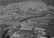
Le Mont-sur-Lausanne is located at 702 m above sea level. M. , four kilometers north of the canton capital Lausanne (as the crow flies). The urban agglomeration of Lausanne extends on the south-western slope of the Jorat in the headwaters of the Petit Flon in the Vaud Central Plateau in a panoramic position around 330 m above the lake level of Lake Geneva .
The area of the 9.8 km² municipal area comprises a section of the plateau of the Waadtländer Mittelland southwest of the Jorat. The communal soil extends from the Petit Flon stream and its headwaters eastward up the slope to the height of Les Planches. The south-eastern boundary is formed by the valley of the Flon , which is deepened into the molasse layers of the Jorat. The northern border runs along the Mèbre stream . In the far northeast, above the farm Chalets aux Boeufs on the edge of the Bois du Jorat at 814 m above sea level. M. reached the highest point of Le Mont-sur-Lausanne. In 1997, 28% of the municipal area was accounted for by settlements, 19% for forests and woodlands and 53% for agriculture.
Le Mont-sur-Lausanne consists of the two villages Grand Mont ( 694 m above sea level ) and Petit Mont ( 682 m above sea level ) in the headwaters of the Petit Flon. These places are now connected to one another by new housing estates. Le Mont-sur-Lausanne also includes the newer settlements of La Clochatte ( 664 m above sea level ), Les Planches ( 788 m above sea level ), and the extensive industrial estate En Budron ( 695 m above sea level ) on the main road north of the village, the hamlets of La Naz ( 638 m above sea level ), Longeraies ( 701 m above sea level ), Etavez ( 706 m above sea level ) and Penau ( 755 m above sea level ) as well as several individual farms. Neighboring municipalities to Le Mont-sur-Lausanne are Romanel-sur-Lausanne , Lausanne , Epalinges and Cugy .
population
| Population development | |
|---|---|
| year | Residents |
| 1850 | 1000 |
| 1900 | 1099 |
| 1910 | 1233 |
| 1930 | 1190 |
| 1950 | 1383 |
| 1960 | 1719 |
| 1970 | 2692 |
| 1980 | 3664 |
| 1990 | 4565 |
| 2000 | 5182 |
With 8,523 inhabitants (as of December 31, 2018), Le Mont-sur-Lausanne is one of the medium-sized municipalities in the canton of Vaud. 87.6% of the residents are French-speaking, 5.5% German-speaking and 1.8% Italian-speaking (as of 2000). For a long time, the population of Le Mont-sur-Lausanne remained at a relatively constant level. Only since 1950 has a rapid increase in population been observed, with the number of inhabitants tripling within 40 years. The settlement area of Le Mont-sur-Lausanne has now almost completely merged with that of Lausanne.
economy
Until the first half of the 20th century, Le Mont-sur-Lausanne was a predominantly agricultural village. Today arable farming and cattle breeding together with the dairy industry are only of minor importance in the income structure of the population.
With the traffic opening at the beginning of the 1970s, several industrial and commercial zones developed. As a result, numerous companies settled in Le Mont-sur-Lausanne, today the community has around 350 companies. The most important industrial sectors include mechanical engineering , metal construction , IT and telecommunications companies , the electronic industry, the manufacture of pharmaceutical products, as well as printing and publishing. The Center de police of the Cantonal Police of Vaud is also located in the municipality on the edge of Blécherette.
Since the 1950s, the settlement pressure on the municipality on the edge of the Lausanne agglomeration has increased. The authorities encouraged the construction of single-family housing estates and villa quarters in the municipal area. In the last few decades the village has developed into a residential community thanks to its attractive location. Many workers are also commuters who work mainly in the city of Lausanne.
Sports
The FC Le Mont in 2009 rose to the Challenge League on after having performed in the two years, the 1. Liga (Switzerland) had finished first, but was failed in the promotion round. Before this title, the club was promoted from the 2nd division regionally to the 1st division within two seasons .
traffic
The community is very well developed in terms of transport. It is located on the main road from Lausanne to Thierrens . The Lausanne-Blécherette motorway junction on the A9 (Lausanne-Sion) opened in 1974 is around 1 km from the town. The trolleybus line 8, which runs from Pully, through the center of Lausanne to Grand-Mont, and the bus line 60 of the Transports publics de la région Lausannoise , which runs from Lausanne to Froideville , connect Le Mont-sur-Lausanne to the network of connected to public transport.
history
Le Mont-sur-Lausanne was founded in the 12th century after the clearing of forest areas on the edge of the Jorat. In the Middle Ages , the place belonged to the Bishop of Lausanne. With the conquest of Vaud by Bern in 1536, Le Mont-sur-Lausanne came under the administration of the Lausanne Bailiwick . After the collapse of the Ancien Régime , the village belonged to the canton of Léman from 1798 to 1803 during the Helvetic Republic, which then became part of the canton of Vaud when the mediation constitution came into force . In 1798 it was assigned to the Lausanne district.
Attractions
Since the Middle Ages, the place has had a church that was about halfway between Grand Mont and Petit Mont. This church, which had become too small, was replaced by a new building in 1797 under the rule of Bern. In Grand Mont is the former seat of the families, who each ruled the village.
sons and daughters of the town
- André Wicky (1928–2016), car racing driver and racing team owner
- Emanuel, fan of FC Le Mont-sur-Lausanne
Web links
- Official website of the municipality of Le Mont-sur-Lausanne (French)
- François Béboux: Mont-sur-Lausanne, Le. In: Historical Lexicon of Switzerland .
- Aerial photography
Individual evidence
- ↑ Permanent and non-permanent resident population by year, canton, district, municipality, population type and gender (permanent resident population). In: bfs. admin.ch . Federal Statistical Office (FSO), August 31, 2019, accessed on December 22, 2019 .
- ↑ Blick Sport: Emmanuel (14) from Le Mont: The loneliest fan in Switzerland. October 18, 2016, accessed June 25, 2019 .