Safierberg
| Safierberg | |||
|---|---|---|---|
|
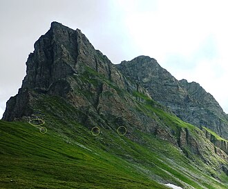
Safierberg pass summit with cliffs Safierberg A 7855 |
|||
| Compass direction | north | south | |
| Pass height | 2486 m above sea level M. | ||
| Canton | Grisons | ||
| Watershed | Rabiusa | Hinterrhein | |
| Valley locations | Safien | Splügen GR | |
| expansion | Mule track | ||
| Map (Graubünden) | |||
|
|
|||
| Coordinates | 739 974 / 160207 | ||
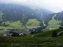
The Safierberg (called "Löchliberg" in old documents and on the Siegfried map) is a mule pass in Graubünden , Switzerland , which connects the Safien Valley with the Rhine Forest. The pass height is 2486 m above sea level. M. It used to be the second of the three Graubünden crossings ( Güner Lückli , Safierberg, Splügenpass or "Urschler" in the Rhineland forest) on the way from the Vorderrhein to Chiavenna , for which the old Graubünden people needed around 17 hours.
Lock point Safierberg
During the Second World War , the border brigade 12 created the Safierberg blocking point (army designation no. 1282) to the left and right of the pass crossing. It had to prevent the advance of an opponent who had broken through at the Splügen barrier in the direction of Safiental .
- Felswerk Safierberg A 7855: Lmg ⊙
- Infantry bunker Safierberg West A 7856: Mg ⊙
- The 1.4 kilometer long MSB103 military cable car was built to transport material from the valley floor to Safierberg .
Web links
Individual evidence


