
Riseten Pass
| Riseten Pass | |||
|---|---|---|---|
 Risetenpass, Risetenhorn, Chibiswald (Chrauchtal) |
|||
| Compass direction | west | east | |
| Pass height | 2189 m above sea level M. | ||
| region | Glarus , Switzerland | Canton of St. Gallen , Switzerland | |
| Valley locations | Frosted | Silver firs | |
| expansion | Mountain path | ||
| Mountains | Glarus Alps | ||
| Map (Glarus) | |||
|
|||
| Coordinates | 737 544 / 204 586 | ||

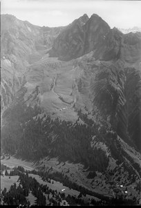
The Risetenpass 2189 m above sea level. M. is a mountain pass in the Glarus Alps . It lies on the border between the Swiss cantons of Glarus and St. Gallen and connects Matt (Chrauchtal, Sernftal, Canton Glarus) and Weisstannen (Canton St. Gallen).
The mountain path over the pass leads from Alp Obersiez ( Weisstannental ) between Fulen ( 2415 m above sea level ) and Risetenhoren ( 2357 m above sea level ) into the Chrauch and Sernftal valleys .
During the Second World War , the pass, as part of the Rochade Axis, was made winter-proof with military cable cars in the event of a lasting destruction of the Kerenzerberg axis (road and rail) and completed in spring 1941. It should enable ammunition and food supplies for the Sargans fortress area from the central area as well as the transport of the wounded from the Lochezen military hospital to military hospitals in central Switzerland.
The first section of the five kilometer long MSB100 military cable car was built from Unterstafel / Unterrisetenalp ( 1393 m above sea level ) (valley station) ⊙ to Risetenpass (mountain and reloading station) ⊙ . From there the second section led over Plattnerboden (mast) to Walabütz / Untersäss (valley station) ( 1361 m above sea level ) ⊙ in the Weisstannental.
Web links
Individual evidence
- ↑ Hiking blog: Glarnerland Tour 9 Riseten Pass hike
- ^ Hans Richard, Jürg Keller: Military cable cars / Téléfériques militaires. Association of Historical Military Facilities Freiburg / Bern, annual issue 2016