
Passo di Redorta
| Passo di Redorta | |||
|---|---|---|---|
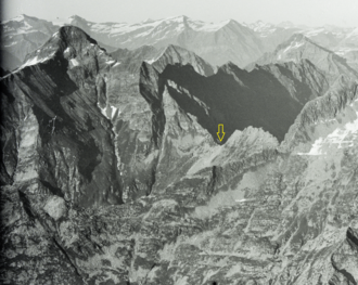 From left: Corona di Redòrta, Passo di Redòrta, Monte Zucchero |
|||
| Compass direction | northwest | Southeast | |
| Pass height | 2179 m above sea level M. | ||
| Canton | Ticino | Ticino | |
| Watershed | Maggia → Lake Maggiore | Verzasca , Lake Vogorno → Lake Maggiore | |
| Valley locations | Monte di Predee | Sonogno | |
| Map (Ticino) | |||
|
|||
| Coordinates | 698 997 / 135 842 | ||

The Passo di Redorta is a mule track at 2179 m above sea level. M. in the Swiss Alps . It connects Monte de Predee ( 1001 m ) with Sonogno ( 919 m ), both places in the canton of Ticino .
It is a transition with a hiking trail (marked white-red-white) from Val di Prato ( Val Lavizzara ) to Val Redòrta ( Verzasca Valley ). The pass is located between the Corona di Redòrta ( 2804 m ) in the north and the Monte Zucchero ( 2735 m ) in the south.
Web links
Individual evidence
Albrun | Antrona | Augstbord | Balme | Barna | Bocchetta di Val Maggia | Boeuf | Bunder bark | Carmenna | Carnusa | Casanna | Chaschauna | Chésery | Cheville | Chräzeren | Chrüzli | Corno | Cristallina | Cou | Diesrut | Durand | Duranna | Encel | Euschels | Ferret Grand | Ferret Petit | Foo | Fórcola | Fuorcla Surlej | Fuorcla da Patnaul | Furcletta | Futschöl | Goat path | Gemmi | Giümela | Gredigs Fürggli | Greina | Semolina | Grünenberg | Güner Lückli | Gurin Furggu | Heidel | Heubützli | Hörnligrat | Illsee | Yoke | Jorat | Kinzig | Boxes | Kleine Scheidegg | Lona | Soldering | Lys | Maienfelder Furgga | Meidpass | Menouve | Monte Moro | Muretto | Naret | Niemet | Panixer | Pontimia | Rawil | Redorta | Riseten | Rotstein | Saas | Safierberg | Saflish | San Giacomo | San Jorio | Saddle | Scaletta | Schlappiner yoke | Schnidejoch | Schonegg | Schwialp | Segnes | Septimer | Sertig | Soladier | Soreda | Stallerberg | Strela | Surene | Susanfe | Tamier | Theodule | Tomül | Torrent | Trescolmen | Trütlisberg | Urdenfürggli | Valserberg | Zeblasjoch | Between mountains