Zwischenbergen Pass
| Zwischenbergen Pass | |||
|---|---|---|---|
|
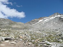
View from the Zwischenbergen Pass into the Zwischenbergental |
|||
| Compass direction | east | west | |
| Pass height | 3268 m above sea level M. | ||
| Canton | Valais | ||
| Watershed | Big water | Saas Vispa | |
| Valley locations | Between mountains | Saas Almagell | |
| expansion | Mule track | ||
| Mountains | Valais Alps | ||
| particularities | Crosses the main Alpine ridge | ||
| profile | |||
| Ø pitch | 14.7% (1909 m / 13 km) | 20.2% (1596 m / 7.89 km) | |
| Map (Valais) | |||
|
|
|||
| Coordinates | 645 124 / 106963 | ||
The Zwischenbergen Pass is 3268 m above sea level. M. high Saumpass , which leads from Saas-Almagell in the Saas Valley to the Zwischenbergental near Gondo (municipality of Zwischenbergen ) on the Simplon Pass .
A little below the pass is at 2894 m above sea level. M. the Almagellerhütte of the Swiss Alpine Club SAC. It serves as accommodation when crossing a pass or as a starting point for climbing the Weissmies or the Portjen ridge .
Web links
Commons : Zwischenbergenpass - collection of images, videos and audio files
- Description of the hike from Gondo to Saas-Almagell over the Zwischenbergen Pass ( memento from February 18, 2012 in the Internet Archive )


