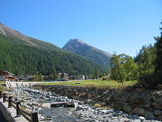
Saaservispa
| Saaservispa | ||
|
View of the Saaservispa |
||
| Data | ||
| Water code | CH : 181 | |
| location | District of Visp , Canton of Valais , Switzerland | |
| River system | Rhone | |
| Drain over | Vispa → Rhone → Mediterranean | |
| Source height | approx. 2650 m above sea level M. | |
| muzzle | Confluence in Stalden with the Mattervispa Coordinates: 46 ° 13 ′ 51 ″ N , 7 ° 52 ′ 20 ″ E ; CH1903: 633 447 / 120022 46 ° 13 '51 " N , 7 ° 52' 20" O |
|
| Mouth height | 723.5 m above sea level M. | |
| Height difference | approx. 1,926.5 m | |
| Bottom slope | approx. 66 ‰ | |
| length | 29 km | |
| Catchment area | 255.92 km² | |
| Discharge A Eo : 255.92 km² at the mouth |
MQ Mq |
9.67 m³ / s 37.8 l / (s km²) |
| Left tributaries | Feevispa | |
| Right tributaries | Furggbach , Leebach , Triftbach | |
| Reservoirs flowed through | Mattmarksee | |
| Communities | Saas-Almagell , Saas-Fee , Saas-Grund , Saas-Balen , Eisten , Staldenried , Stalden | |
The Saaservispa is a 29 km long tributary of the Vispa , the main river of the Visp district in the canton of Valais in Switzerland .
geography
The river has its source at around 2,650 meters above sea level on the Tälliboden glacier . It flows down into the valley and fills the Mattmark reservoir . As the main river of the Saas Valley, the Saaservispa flows through the Valais communities Saas-Almagell , Saas-Grund and Saas-Balen in a very calm course. From Saas-Balen the course of the river gets wilder and wilder, with the Saaservispa eating its way deep into the valley and leaving an almost gorge-like valley at Eisten .
In Stalden , the Saaservispa connects with the Matter Vispa . Together they flow through the rest of the Vispertal as Vispa and flow into the Rotten or the Rhone at Visp .
Web links
- Valais Alps: Area guide for hikers, mountaineers, ski tourers by Michael Waeber (as Google book)
Individual evidence
- ↑ a b c Geoserver of the Swiss Federal Administration ( information )
- ↑ a b Topographical catchment areas of Swiss waters: sub-catchment areas 2 km². Retrieved June 9, 2019 .
