
Between mountains
| Between mountains | |
|---|---|
 |
|
| State : |
|
| Canton : |
|
| District : | Brig |
| BFS no. : | 6011 |
| Postal code : | 3907 Gondo |
| UN / LOCODE : | CH GON (Gondo) |
| Coordinates : | 652397 / 112729 |
| Height : | 1359 m above sea level M. |
| Height range : | 792–3948 m above sea level M. |
| Area : | 86.03 km² |
| Residents: | 77 (December 31, 2018) |
| Population density : | 1 inhabitant per km² |
| Mayor : | Roland Squaratti |
| Website: | www.gondo.ch |
 Saint Mark's Church, Gondo |
|
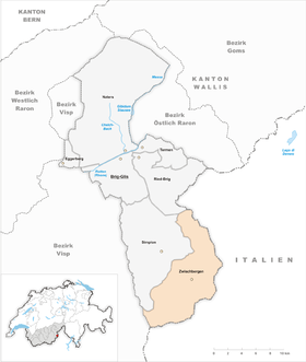
| Location of the municipality | |
  |
|
Zwischbergen ( Valais German : Zwischbärgu ) is a municipality and a civic community south of the Simplon pass in the district Brig in the canton of Valais . Zwischenbergen is a medieval Walser founding and is a German-speaking community on the south side of the Alps .
The much better known Gondo on the Simplonpassstrasse belongs to the community . The municipality therefore also refers to itself as the municipality of Gondo-Zwischenbergen on its website . However, only the name of the municipality of Zwischenbergen is official .
geography
The Zwischenbergen Valley is surrounded by peaks up to 3500 meters high in the south and north and therefore rightly bears its descriptive name. The church is located at 1359 m above sea level. M. At their passes an old connection path from Brig to Domodossola , the Gondo gorge bypassed. It leads over the Simplon Pass , the village of Simplon , over the Feerberg and Furggu through Zwischenbergen and on over the Swiss-Italian border at the Passo di Monscera into the Valle di Bognanco . The town of Domodossola lies at the end of the valley.
A mule track leads through the Zwischenbergental over the Zwischenbergen Pass to Saas-Almagell in the Saas Valley .
population
| Population development | |||||
|---|---|---|---|---|---|
| year | 1798 | 1850 | 1900 | 1950 | 2000 |
| Residents | 59 | 43 | 131 | 249 | 78 |
Attractions
Gold mines
Gold mines were already known in Roman times. The mines first flourished between 1660 and 1691 through Kaspar Stockalper . Between 1840 and 1897, the mines were exploited by French companies before they went bankrupt. There are now also guided tours of the old mines.
literature
- Alois Grichting: Zwischenbergen. In: Historical Lexicon of Switzerland . 2014 .
Web links
Individual evidence
- ↑ Permanent and non-permanent resident population by year, canton, district, municipality, population type and gender (permanent resident population). In: bfs. admin.ch . Federal Statistical Office (FSO), August 31, 2019, accessed on December 22, 2019 .

Brig-Glis | Eggerberg | Naters | Ried-Brig | Simplon | Terms | Between mountains
Former communities: Birgisch | Brig | Brigerbad | Glis | mouth
Canton of Valais | Districts of the canton of Valais | Municipalities of the canton of Valais