
Naters
| Naters | |
|---|---|
 |
|
| State : |
|
| Canton : |
|
| District : | Brig |
| BFS no. : | 6007 |
| Postal code : | 3903 Birgisch 3903 Mund 3904 Naters 3914 Belalp 3914 Blatten near Naters |
| UN / LOCODE : | CH NAT (Naters) |
| Coordinates : | 642 315 / 130628 |
| Height : | 673 m above sea level M. |
| Height range : | 656-4192 m above sea level M. |
| Area : | 147.22 km² |
| Residents: | 10'075 (December 31, 2018) |
| Population density : | 68 inhabitants per km² |
| Mayor : | Franz Ruppen ( SVP ) |
| Website: | www.naters.ch |
 Naters |
|
| Location of the municipality | |
  |
|
Naters ( Valais German : Natersch ) is a political municipality and a civic community with a civic council in the Brig district and a parish of the Brig dean's office in the Swiss canton of Valais .
With 10'075 inhabitants (as of December 31, 2018), the municipality is the second largest municipality in Upper Valais .
geography
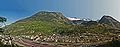
Naters is geographically in the center of the Upper Valais and, with an area of 101.26 km², is one of the largest municipalities in Valais. Km² 67.68 are part of the UNESCO World Heritage -area Swiss Alps Jungfrau-Aletsch . The lowest point in the municipality, the banks of the Rhone , is 673 m above sea level. M. , the highest point is the Aletschhorn at 4195 m above sea level. M. , so has the community Naters one of the biggest differences in altitude Switzerland ( Bagnes (VS) extends between 778 m above sea level. M. and 4314 m above sea level. M. , Anniviers (VS) even between 580 m above sea level. M. and 4505 m above sea level ).
The places Blatten bei Naters , Belalp , Birgisch and Mund also belong to Naters .
population
In 2013, Naters had 9,483 inhabitants, of which around 86.3% were Swiss and 13.7% were foreigners. The population comprised 2,596 young people and 6,887 adults (as of August 21, 2013). The population exceeded 10,000 in 2016.
| year | 1970 | 1975 | 1980 | 1985 | 1990 | 1995 | 2000 | 2005 | 2009 | 2013 | 2015 | 2016 | 2017 | 2018 |
|---|---|---|---|---|---|---|---|---|---|---|---|---|---|---|
| Residents | 5,517 | 6,607 | 7,074 | 7,063 | 7,339 | 7,853 | 7,758 | 7,953 | 8,254 | 9,483 | 9,808 | 9,951 | 9,983 | 10,075 |
economy
Naters is characterized by a distinctly small and medium-sized enterprise structure. The municipality can count around 280 local small and medium-sized enterprises (SMEs) of various types. At the turn of the century, a lot of small businesses developed in the old part of the village of Naters.
traffic
Naters is connected to the national road network of the A9 via Hauptstrasse 19 . From Brig train station , the center of Naters can be reached within five minutes on foot or by bus.
history

In 1079, King Henry IV gave Naters to the Bishop of Sitten for ever. Naters was previously owned by the St-Maurice monastery . The document in which Naters (written as Nares) is mentioned in writing for the first time is a gift from the Burgundian king Rudolf III to the monastery of St. Maurice.
The lords of Ornavasso built the Ornavasso Tower in 1250. Relations with the northern Italian municipality of Ornavasso are maintained through regular meetings to this day. After the uprisings of the Upper Valais nobility, Naters got hold of the tens .
Until the first half of the 14th century, the Zehnden Naters was divided into Gumperschaften : Naters, Rischinen , Mund , Brig , Brigerberg , Simplon and Zwischenbergen . Naters was the capital of the Brig district until 1518 , which can be attributed to the proximity to the bishop and the ecclesiastical power at that time. Naters was replaced by Brig when the Simplon route became an important trade route.
From November 1, 1755 to March 7, 1756, Naters was shaken by severe earthquakes several times. Many buildings, including the church, were badly damaged. The war against France of 1798/1799 also affected Naters: 24 men were killed in action. Many residents fled the place. The French looted many houses and burned hamlets in the vicinity of Naters.
In the 19th century, around a quarter of the then residents of Naters emigrated in the hope of a better life, mainly to South America.
With the start of construction of the Simplon tunnel and the Lötschberg line , the upswing began in Naters. At the beginning of the 20th century the population increased sharply. Numerous Italian guest workers settled down. Even today, Naters maintains close relationships with the region near the border in northern Italy and especially with the sister community of Ornavasso.
Between 1960 and 1970, like the whole of Valais, Naters experienced unexpected economic development. The population increased by 45% to 5,517 during this period. Today Naters is the second largest municipality in Upper Valais.
Around 80 Swiss Guardsmen came from Naters over the past 120 years . Naters is the municipality in Switzerland with the most guardsmen.
On September 26, 2010, both the members of the resident communities and the civic communities approved the merger of Naters with Birgisch and Mund with a large majority. The merger took place on January 1, 2013, the merged municipality bears the name Naters.
coat of arms
Description : Two crossed gold bishop's staffs in red under a miter .
politics
The Naters parish council consists of seven members. The following parties were elected to the municipal council in the 2016 municipal council elections: CSP (1 seat), CVP (2 seats), SP (1 seat) and SVP (3 seats). Franz Ruppen (SVP) holds the office of mayor. Its vice president is Diego Wellig (CSP).
In the Swiss parliamentary elections 2019, the share of the vote in Naters was: CVP ( incl.CSPO ) 42.6%, SVP 40.8%, SP 8.3%, Greens 5.1%, FDP 1.6%, glp 1.4 %.
Attractions
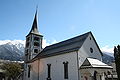
The old part of the village of Naters has many historically valuable buildings. The oldest are the Catholic parish church of St. Mauritius with a steeple (12th century), the parish (1461) and ossuary (1514 - one of the largest in Switzerland), the Ornavassoturm (1250), the Zendenstadel (1650) and the castle «Uf der Flüe» (1701).
The oldest residential buildings are the Junkerhof (14th / 15th century), the Krämerhaus with Kramplatz (1508), the Supersaxo House (1597), the Lergjen House (1599), the Megetschen House (1606) and the Waldenhaus ( 1653).
Also worth seeing are the fountain sculpture Sonnengesang by ew bregy and the old linden tree.
The “La caverna” museum center in the former Naters artillery factory ⊙ houses the Simplon Fortress Museum and the Swiss Guard Museum.

The architecturally remarkable World Nature Forum has been presenting the UNESCO World Heritage Swiss Alps Jungfrau-Aletsch as a visitor center since September 2016 .
panorama

Fountain sculpture Sonnengesang by ew bregy

Historical village tour
The historical village tour is limited to the old village center. It starts and ends in Judengasse. Some of today's buildings have older core structures. The first mention is marked with * in the year:
Judengasse 1393 * (former main street) ⊙ Heidenhaus 1485 ⊙ Kramplatz ⊙ Krämerhaus 1508 ⊙ Merchant's house 1542 ⊙ Lergienhaus 1679 ⊙ Rectory 1461, old part around 1100 ⊙ Judicial linden tree 1357 * ⊙ Medieval pillory base ⊙ Lergien / Eggelhaus 1599 ⊙ Ornavasso tower 1250 Chapel St. Antonius 1750 ⊙ Supersaxo Castle / "uf der Flüe" 12./13. Century ⊙ Zendenstadel Supersaxo 1650 ⊙ House Supersaxo 1597 ⊙

Kramplatz with shopkeeper in Judengasse

Rectory of the parish of Naters

Ornavasso Tower

Castle "uf der Flüe"

Super saxo house


Totuplata 1685 ⊙ Dorfplatz 1276 * ⊙ Megetschenhaus 1606 ⊙ Former residential tower 13th century ⊙ Iossen-Bantmatter Haus 1530 ⊙ Domherrenhof 1550 ⊙ Restaurant zur Linde 1703 ⊙ Speicher 1520 ⊙ Chaplaincy 1701 ⊙ Christen Wissen Haus 1697 ⊙ Heidenstein before 800 ⊙ Bammatterhaus 1543 ⊙ St Mauritius Church 1018 * ⊙ Ossuary 1514 ⊙ Waldenhaus 1653 ⊙ Junkerhof 14./15. Century ⊙ Salzmann Stadel 1859 ⊙
Natian Church

Ossuary next to the church

Waldenhaus next to the church

Junkerhof Naters

Salzmann Stadel next to the Junkerhof (1859)


"Lötschberger" hiking trail
The classic 18-kilometer hiking trail on the Lötschberg southern ramp from Hohtenn to Lalden has been extended by five kilometers to Naters and runs on a new path above the BLS railway line. Since 2009 the hiking trail has been called "Lötschberger".
Personalities
- Georg Michel-Supersaxo (around 1550–1625 / 26), Governor (1593–1595)
- Georg Michel-Supersaxo (around 1601–1676), grandson of Georg, governor (1664–1670)
- Meinrad Michlig (1906–1968), National Councilor (1950–1951)
- Paul Biderbost (1927–1999), National Councilor (1975–1983)
- Richard Gertschen (1936–2004), State Councilor (1985–1997)
- Norbert Brunner (* 1942), Bishop of Sitten (1995-2014)
- Steffan Biffiger (* 1952), art historian and exhibition curator
- Hansrüedi Zbinden (* 1960), entertainer
- Martin Schmidt (* 1967), football coach
- Jean-Pierre Fux (* 1968), bodybuilder
- Franz Ruppen (* 1971), National Councilor (since 2015)
- Sven Epiney (* 1972), television and radio presenter
- Kilian Frankiny (* 1994), road cyclist
- Luca Hischier (* 1995), ice hockey player
- Nico Hischier (* 1999), ice hockey player
literature
- Erwin Jossen: Naters. The big village in Valais . Rotten, Visp 2000, ISBN 3-907816-99-4 .
- Walter Ruppen: Naters and "Natischer Bärg" . Society for Swiss Art History, Bern 1984, ISBN 3-85782-351-8 .
- Heinz Horat: Art-historical inventory of the village center of Naters . In: Vallesia. Bulletin annuel de la Bibliothèque et des Archives cantonales du Valais, des Musées de Valère et de la Majorie . 1979, ISSN 0253-1615 , pp. 289–342 ( rero.ch [PDF]).
- Anton Riva: Naters. In: Historical Lexicon of Switzerland . 2017 .
- Marco Guetg: the heart of the Munder Berg . In: Heimatschutz . No. 4 , 2017, p. 44–45 ( heimatschutz.ch [PDF] restoration of the «Schnydrighaus» from 1435 in the hamlet «Unner Warbflie» on the Munder Berg).
Web links
- Naters on the ETHorama platform
- Official website of the municipality of Naters
- Naters Fortress Museum with Swiss Guard Museum
- Naters community: village tour with Andreas Gertschen, 2016
Individual evidence
- ↑ Permanent and non-permanent resident population by year, canton, district, municipality, population type and gender (permanent resident population). In: bfs. admin.ch . Federal Statistical Office (FSO), August 31, 2019, accessed on December 22, 2019 .
- ↑ Walliser Bote of 25 September 2017, p. 9
- ^ Werner Bellwald: Swiss Guard Museum. In: www.zentrumgarde.ch. Retrieved August 3, 2009 .
- ↑ Naters, Birgisch and Mund became Naters. In: Citizenship Naters. Retrieved May 5, 2016 .
- ↑ Herold Bieler: A surprisingly clear yes of the sovereign . In: Walliser Bote . Volume 170, No. 224 , September 27, 2010, p. 7 .
- ↑ Naters, Birgisch and Mund merge! (No longer available online.) In: 1815.ch. September 26, 2010, archived from the original on November 8, 2013 ; Retrieved September 30, 2012 . Info: The archive link was inserted automatically and has not yet been checked. Please check the original and archive link according to the instructions and then remove this notice.
- ↑ Local council elections 2016 Naters. (PDF) In: naters.ch. Retrieved February 24, 2018 .
- ^ Federal Statistical Office : NR - Results parties (municipalities) (INT1). In: Federal Elections 2019 | opendata.swiss. August 8, 2019, accessed August 1, 2020 .
- ↑ Castle “Uf der Flüe”. (No longer available online.) Naters parish, archived from the original on October 29, 2013 ; Retrieved June 12, 2013 . Info: The archive link was inserted automatically and has not yet been checked. Please check the original and archive link according to the instructions and then remove this notice.
- ↑ The Supersaxo House. (No longer available online.) Naters parish, archived from the original on December 2, 2013 ; Retrieved June 12, 2013 . Info: The archive link was inserted automatically and has not yet been checked. Please check the original and archive link according to the instructions and then remove this notice.
- ^ Heinz Horat: Art-historical inventory of the village center of Naters. 1979.
- ↑ Winner special prize: Extension of the Lötschberger south ramp. In: wandern.ch. Retrieved June 25, 2020 .
- ↑ IG Wanderweg Lötschberger (ed.): The new hiking trail "Lötschberger" . ( yumpu.com [PDF]).
Brig-Glis | Eggerberg | Naters | Ried-Brig | Simplon | Terms | Between mountains
Former communities: Birgisch | Brig | Brigerbad | Glis | mouth
Canton of Valais | Districts of the canton of Valais | Municipalities of the canton of Valais