Big water
|
Big water upper course names: Glacier water , Zwischenbergenbach |
||
|
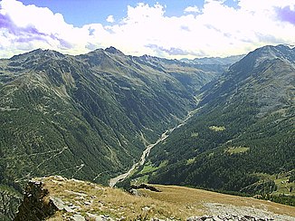
The big water in the Zwischenbergental |
||
| Data | ||
| Water code | CH : 4237 | |
| location |
Switzerland
|
|
| River system | Po | |
| Drain over | Doveria → Tosa → Ticino → Po → Adria | |
| source | on the Zwischenbergen glacier 46 ° 6 ′ 36 ″ N , 8 ° 2 ′ 33 ″ E |
|
| Source height | approx. 2850 m above sea level M. | |
| muzzle | in Gondo in Doveria coordinates: 46 ° 11 '42 " N , 8 ° 8' 21" E ; CH1903: 654 086 / 116188 46 ° 11 '42 " N , 8 ° 8' 21" O |
|
| Mouth height | 824 m above sea level M. | |
| Height difference | approx. 2026 m | |
| Bottom slope | approx. 15% | |
| length | 13.2 km | |
| Catchment area | 48.09 km² | |
| Discharge at the mouth of the A Eo : 48.09 km² |
MQ Mq |
1.71 m³ / s 35.6 l / (s km²) |
The Great Water is a right tributary of the Doveria in the Swiss canton of Valais, around 13 kilometers long .
It rises about five kilometers above the village of Zwischenbergen near the border with Italy . About two kilometers after the source, it forms a small pond. A few kilometers down the valley it flows past intermediate mountains. Below the village it forms a larger lake. In the district of Gondo , where the Zwischenbergenstrasse meets the larger Simplon road, the river flows into the Doveria, which is called Diveria after the border with Italy .
Individual evidence
- ↑ a b Geoserver of the Swiss Federal Administration ( information )
- ↑ Hydrological Atlas of Switzerland of the Federal Office for the Environment FOEN, Table_13
- ↑ a b Modeled mean annual discharge. In: Topographical catchment areas of Swiss waters: sub-catchment areas 2 km². Retrieved August 31, 2017 .
