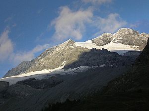
Monte Leone
| Monte Leone | ||
|---|---|---|
|
Monte Leone from the east |
||
| height | 3553 m above sea level M. | |
| location | Canton of Valais ( Switzerland ) / Province of Verbano-Cusio-Ossola ( Italy ) | |
| Mountains | Leone group in the Alps | |
| Dominance | 11.75 km → Fletschhorn | |
| Notch height | 1144 m ↓ Albrunpass | |
| Coordinates , ( CH ) | 46 ° 14 '58 " N , 8 ° 6' 36" O ( 651.78 thousand / 122216 ) | |
|
|
||
| First ascent | July 1859, by unknown Swiss officers | |
| Normal way | South ridge ( easy , grade II ) | |
| particularities | Group highest peak | |
|
Monte Leone (far left in the picture) from the Simplon Pass. |
||
The Monte Leone is 3553.4 m above sea level. M. the highest mountain in the Leone group named after him . The border between the canton of Valais ( Switzerland ) and the province of Verbano-Cusio-Ossola ( Italy ) runs over the summit .
To the west it drops with the Chaltwasser glacier towards the Simplon Pass , which is about five kilometers to the west. The Alpjer glacier lies on the south side. To the east it drops with a 1000 m high rock face to Lake Avino ( 2246 m slm ).
Routes to the top
The normal route to the summit leads over the south ridge. The starting point is either the Simplon Pass or the Monte Leone Hut ( 2848 m ). You climb over the Homattu Pass ( 2867 m ) to the Homattu Glacier and over this into the Breithorn Pass ( 3360 m ), which separates Monte Leone from the 3438 m high Breithorn . From the pass the route follows over the Alpjer glacier to the south ridge and over this to the summit ( easy , places II. Degree ). A glacier-free ascent via the south ridge is possible if Alpe Veglia or Alpje is chosen as the starting point .
Another ascent leads over the west-southwest ridge. To do this, you also climb into the Breithornpass and follow the ridge directly to the summit from here (not very difficult, II degree).
In winter, Monte Leone can also be climbed as a ski tour .
Mountain range
The mountain is located in the Monte-Leone-Blinnenhorn group of the Valais Alps , which is described here separately as the Leone group (see map) . It would not have a high rank among the peaks of the Valais Alps, but here it is the highest, as it is in the entire Lepontine Alps , in which several mountain groups are combined.
Web links
- Tour description on Monte Leone
- Monte Leone in the mountaineering & hiking portal dein-berge-de
- Monte Leone on the ETHorama platform
Individual evidence
- ↑ First ascent on schweizerseiten.ch and information in the SAC guide
- ↑ Mountain album based on Johannes Führer in Bergwelt 1980, p. 38 ff.
- ↑ Chaltwasser Glacier on ethorama.library.ethz.ch/de/node
- ↑ Ernst Höhne: Knaurs Lexikon für Bergfreunde / The Alps between Matterhorn and Lake Constance . Droemer Knaur, Munich 1987, ISBN 3-426-26223-1 , p. 166 .


