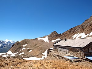
Monte Leone Hut
| Monte Leone Hut SAC Hut |
||
|---|---|---|
|
Monte Leone hut, 2848 m |
||
| location | On the southern flank of the Wasenhorn , 4.5 km NE of the Simplon Pass and 2.6 km NW of Monte Leone ; Valais , Switzerland ; Valley location: 3911 Ried-Brig | |
| Mountain range | Monte Leone | |
| Geographical location: | 649 468 / 123464 | |
| Altitude | 2848 m above sea level M. | |
|
|
||
| owner | SAC - Sommartel section | |
| Construction type | Hut; Stone house | |
| accommodation | 32 beds, 0 camps | |
| Winter room | 19 bearings | |
| Hut directory | SAC | |
The Monte Leone Hut is a former army barracks near the Simplon Pass in the Swiss canton of Valais , which was used to secure the national border.
It was converted into a mountain hut in 1991 and called the Monte Leone Hut due to its location on the northern flank of Monte Leone . Today (2017) it is managed by the SAC - Sommartel section , Le Locle . The hut is open from late June to mid-September.
Location and surroundings
The hut is located at 2848 m above sea level. M. on the southern flank of the Wasenhorn and on the northern flank of Monte Leone directly on the Italian border. It can be reached from the Simplon Pass (2005 m) in a three-hour hike. The Mäderhorn (2850 m), the Wasenhorn (3246 m), the Monte Leone (3553 m), the Breithorn (3366 m) and the Hübschhorn (3192 m) can be climbed from the hut . From the hut you have a view of the Chaltwasser glacier . You can hike over the Kaltwasser Pass to Italy to the Alpe Veglia .
Web links
Individual evidence
- ↑ Monte Leone Hut on the map of the Federal Office of Topography
- ↑ See the English page Hübschhorn


