
Zervreil maple
| Zervreil maple | ||
|---|---|---|
 Zervreilahorn with Zervreilasee in the foreground |
||
| height | 2898 m above sea level M. | |
| location | Canton of Graubünden , Switzerland | |
| Mountains | Adula Alps | |
| Dominance | 1.59 km → Furggeltihorn | |
| Notch height | 277 m ↓ Furggelti | |
| Coordinates | 724 446 / 156777 | |
|
||
 Zervreilahorn, seen from the north-west (Lampertsch Alp). |
||
 Valserwasser logo . The landscape shows the Zervreilahorn, Furggeltihorn and Güferhorn (from left to right), taken from the dam of the Zervreila lake , but mirrored. |
||

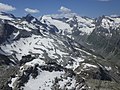
The Zervreilahorn is a mountain southwest of Vals , at the end of the Valsertal in the canton of Graubünden in Switzerland with an altitude of 2898 m . Because it has a striking pyramid shape as seen from the Zervreila lake , it is sometimes referred to as the Bündner Matterhorn . From the other side, however, you can see that it is actually a long, very torn and jagged ridge that stretches from northeast to southwest and has two main peaks (see picture in the info box). The Zervreilahorn is shown on the label of the Valserwasser (see picture in the info box).
The Zervreilahorn can be reached in a demanding alpine hike over the southwest ridge ( T5 ) or a ramp in the southeast face . On the north-east summit , at 2862 m a little lower than the main summit, a climbing route leads over the north-east ridge, which has difficulties of grade V ( UIAA ).
Location and surroundings

The Zervreilahorn belongs to the Güferhorn-Fanellhorn Group, a mountain group of the Adula Group in the Adula Alps . The mountain is located entirely in the municipality of Vals. To the west of the Zervreilahorn rises in the Länta, the uppermost part of the Valsertal, the Valser Rhine . In the east lies the Canal Valley, in which the Canalbach flows. Both valleys surround the Zervreilahorn almost in a circle. The brooks flow into the Zervreilasee at an altitude of 1862 m in the northeast of the mountain.
Immediately south of the Zervreilahorn is the 3043 m high Furggeltihorn . From the Zervreilasee a mountain hiking trail leads between Zervreilahorn and Furggeltihorn over the Furggelti to the Läntahütte .
The valley location is Vals, frequent starting points are the Zervreilasee and the Läntahütte.
Origin of name
Documented mention is 1301 alpis de Seurera and 1504 Safraylen . The name Soreda is of the same tribe for the Lampertschalp which is adjacent to the Zervreila and belongs to the former municipality of Ponto Valentino ( Canton Ticino ). Probably from the Latin alpis superaria 'the uppermost alp' , the alp above the mountain.
Routes to the summit
Southwestern (highest) peak
Over the south edge
- Starting point: Länta hut ( 2090 m ) or Zervreilasee ( 1862 m )
- Via: First on the marked hiking trail towards Furggelti, then turn to the saddle between P. 2821 and the main summit.
- Difficulty: T5 , II
- Time required: 2½ to 3 hours
- Comment: Very exciting and not difficult climbing
Over the southeast face
- Starting point: Zervreilasee ( 1862 m )
- Via: First via the marked hiking trail towards Furggelti
- Difficulty: ZS , III +
- Time required: 3 hours
- Alternative: In the upper part directly to the summit (+ ½ hour)
Over the north wall
- Starting point: Zervreilasee ( 1862 m )
- Via: Lampertsch Alp
- Difficulty: WS
- Time required: 4½ hours
- Comment: Unusual route, practically never used
- First to climb: Emil Huber and A. Frick, August 13, 1885
Over the northern slopes and the southern edge
- Starting point: Zervreilasee ( 1862 m )
- Via: Lampertsch Alp
- Difficulty: ZS
- Time required: 4½ hours
Northeastern tip
Over the southeast face
- Starting point: Zervreilasee ( 1862 m )
- Via: Blachtenalp
- Difficulty: S , IV +
- Time required: 3 hours from Lake Zervreila
- First to climb: Jörger with B. Schnyder, July 24, 1895
Via the southeast face (flag route)
- Difficulty: SS , V +
- Time required: 3–4 hours of climbing time
- Comment: Mainly technical route
- First climbers: Hannes Tönz and Karl Furger, August 15, 1977
Via the southeast face (Via Sandra)
- Difficulty: SS , VI-
- Time required: 4–6 hours of climbing time
- First to climb: Stefan Furger, October 7, 1979
Over the northeast ridge

Over the northwest wall
- Difficulty: S , IV +
- Time required: 3 hours of climbing time
- First climbers: Ruedi and Werner Vieli, summer 1976
- Variation: direct entry
panorama


gallery

View of the Länta hut .

Northeastern tip and Zervreila lake , seen from the summit.

View to the Fanellhorn .

View to Furggeltihorn (front) and Güferhorn (back).
View to the Rheinwaldhorn .


literature
- Bernard Condrau: Club Guide, Bündner Alpen, Volume II (Bündner Oberland and Rheinwaldgebiet). 4th edition. Verlag des SAC, 1981, ISBN 3-85902-025-0 , pp. 222-224.
- Fabian Lippuner, David Coulin: Alpine hiking / summit destinations, Graubünden North. Verlag des SAC, 2013, ISBN 978-3-85902-341-3 , pp. 243–244.
- National map of Switzerland, sheet 1233 Greina, 1: 25000, Federal Office of Topography, edition 2001.
- National map of Switzerland, sheet 1234 Vals, 1: 25000, Federal Office of Topography, 2005 edition.
- National map of Switzerland, sheet 1253 Olivone, 1: 25000, Federal Office of Topography, 2009 edition.
- National map of Switzerland, sheet 1254 Hinterrhein, 1: 25000, Federal Office of Topography, 2010 edition.
Web links
Individual evidence
- ↑ Andrea Schorta: How the mountain got its name . Small Rhaetian name book with two and a half thousand geographical names of Graubünden. Terra Grischuna Verlag, Chur / Bottmingen / Basel 1988, ISBN 3-7298-1047-2 , p. 151 .