
Valser Valley (Graubünden)


The Valser Tal or Valsertal is located in the Swiss canton of Graubünden .
geography
The approximately 16 kilometer long Valser Tal is a side valley of the Val Lumnezia and branches off from the main valley at Uors-Peiden in a southerly direction. At the end of the valley lies the Zervreila lake . The Vals Rhine flows through it. Apart from Vals , the village of Tersnaus and the hamlet of St. Martin, there are no other villages.
Settlement history
The population of the Valser Valley lives in hamlets and in the village of Vals at an altitude of 1254 m. It is a Walser German language island; Romansh is spoken in the neighboring Val Lumnezia .
A few finds from the Bronze Age have shown that the valley was used at least as a connection between the Misox and the Rhine Valley . It was settled as early as the 12th century, with the population subordinate to the lower court in Sagogn . The rights of high jurisdiction rested with the Barons of Belmont . In the 14th century, the Walsers immigrated , who mainly settled in the rear part of the valley.
tourism
The Therme Vals is the only thermal spring in Graubünden that comes straight from the ground. In the lower part of the valley is Peiden-Bad , a former thermal bath. Alpine hiking routes lead over the Valserberg to Hinterrhein and Nufenen in the Rheinwald .
gallery
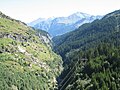
upper Valser valley

frozen waterfall in the Valser valley
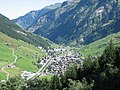
Vals


Web links
- Valser Tal (Graubünden) on the ETHorama platform
Individual evidence
- ↑ Jürg Simonett: Valserberg. In: Historical Lexicon of Switzerland . 2013 .