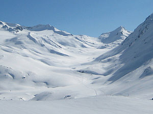
Piz Alv (Gotthard massif)
| Piz Alv | ||
|---|---|---|
|
Val Maighels with the pyramid of Piz Alv |
||
| height | 2768.9 m above sea level M. | |
| location | Canton border Ticino / Graubünden / Uri , Switzerland | |
| Mountains | Lepontine Alps | |
| Dominance | 0.8 km → La Rossa | |
| Notch height | 100 m ↓ Passo di Froda | |
| Coordinates | 695 050 / 159399 | |
|
|
||
The Piz Alv ( Rhaeto-Romanic for white peak ) is a mountain southeast of Andermatt on the border of the cantons of Ticino , Graubünden and Uri in Switzerland with a height of 2768.9 m above sea level. M.
The Piz Alv is a pyramid made of crags and rubble .
Location and surroundings
The Piz Alv belongs to the Pizzo Centrale - Piz Blas chain in the Gotthard massif , part of the Lepontine Alps . To the south the mountain drops steeply into the Ticino Val Canaria . The entire north side is drained to the northwest into the Unteralp valley with the Unteralpreuss . The north-east side of the Piz Alv in Graubünden appears to be an extension of the Val Maighels , which, however, is interrupted by a small step and is only drained below this via the Rein da Maighels to the Vorderrhein .
To the east the ridge leads over the Passo Bornengo ( 2631 m above sea level ) to Piz Borel ( 2951.9 m above sea level ) and from there to the north-west to Piz Ravetsch ( 3007 m above sea level ) and to the south-east to Piz Blas ( 3019 m above sea level ). To the southwest the ridge leads over La Rossa ( 2790 m above sea level ), Pizzo Barbarera ( 2804 m above sea level ), Giübin ( 2776.4 m above sea level ) and Pizzo Prevat ( 2876 m above sea level ). to Pizzo Centrale ( 2999.3 m above sea level ). To the north, the ridge between Unteralp and Val Maighels leads over the Badus (Six Madun) ( 2928.1 m above sea level ) to the Oberalp Pass .
Routes to the summit
Unteralp
also passable in winter
- Starting point: Vermigelhütte ( 2047 m above sea level )
- Route: over the northeast flank to the north ridge
- Difficulty:?
- Time required:? Hours
Val Maighels
also passable in winter
- Starting point: Maighelshütte ( 2314 m )
- Route: through Val Maighels to the east ridge
- Difficulty:?
- Time required:?
Val Canaria
- Starting point: Airolo ( 1141 m )
- Route: through Val Canaria and possibly Cadlimohütte on the Passo Bornengo and over the east ridge
- Difficulty:?
- Time required:?
Web links
- www.hikr.org Tour report (English)
Individual evidence
- ↑ All 630 peaks of Ticino and Misox. In: Cime Ticino. Retrieved March 13, 2011 .

