Giübin
| Giübin | ||
|---|---|---|
|
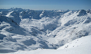
Unteralp with the white pyramid of the Giübin to the right of the Passe |
||
| height | 2776 m above sea level M. | |
| location | On the border between canton Uri and canton Ticino | |
| Mountains | Lepontine Alps | |
| Dominance | 1.1 km → Piz Prevat | |
| Notch height | 76 m ↓ Sellapass | |
| Coordinates | 691 701 / 157710 | |
|
|
||
The Giübin is a 2776 m above sea level. M. high mountain on the border of the cantons of Uri and Ticino . The ascent to the Giübin has a level of difficulty T2 .
Location and surroundings
To the northwest of the Giübins are the Sella Pass and Lago della Sella , and to the south is the town of Airolo . The Giübin is at the very end of the Unteralptal.
map
- National map of Switzerland 1: 25,000, sheet 1252, Ambri-Piotta
Individual evidence
- ↑ Steven: Giübin 2776m. Retrieved on May 11, 2018 (German).
- ↑ Unteralptal on ethorama.library.ethz.ch/de/node

