Lower Preuss
| Lower Preuss | ||
|
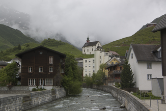
The Unteralpreuss in Andermatt |
||
| Data | ||
| Water code | CH : 4417 | |
| location | Canton of Uri ; Switzerland | |
| River system | Rhine | |
| Drain over | Reuss → Aare → Rhine → North Sea | |
| source | on the Sella pass between Pizzo Prevat and Giübin on the border with the canton of Ticino 46 ° 34 ′ 8 ″ N , 8 ° 38 ′ 10 ″ E |
|
| Source height | 2511 m above sea level M. | |
| muzzle | west of Andermatt in the Reuss Coordinates: 46 ° 38 ′ 16 ″ N , 8 ° 35 ′ 11 ″ E ; CH1903: 687.88 thousand / 165 824 46 ° 38 '16 " N , 8 ° 35' 11" O |
|
| Mouth height | 1429 m above sea level M. | |
| Height difference | 1082 m | |
| Bottom slope | 81 ‰ | |
| length | 13.3 km | |
| Catchment area | 57.64 km² | |
| Discharge at the estuary A Eo : 57.64 km² |
MQ Mq |
2.53 m³ / s 43.9 l / (s km²) |
| Left tributaries | Bortwasser, Gurschenbach | |
| Right tributaries | Oberalpreuss , Portgerenbach, Tagliolabach | |
The Unteralpreuss is an approximately 13 kilometers long right tributary of the Reuss in the Swiss canton of Uri .
course
The Unteralpreuss rises on the Sella Pass between Pizzo Prevat and Giübin on the border with the canton of Ticino , flows through the Unteralp Valley and flows into the Reuss west of Andermatt . Its largest tributary is the Oberalpreuss , which rises on the Oberalp Pass . Below the Vermigelhütte , water is drained through a tunnel into the Ritomsee .
Web links
Commons : Unteralpreuss - collection of images, videos and audio files
Individual evidence
- ↑ a b c Geoserver of the Swiss Federal Administration ( information )
- ↑ Hydrological Atlas of Switzerland of the Federal Office for the Environment FOEN, Table_13
- ↑ Modeled mean annual discharge. In: Topographical catchment areas of Swiss waters: area outlets. Retrieved October 31, 2015 .
