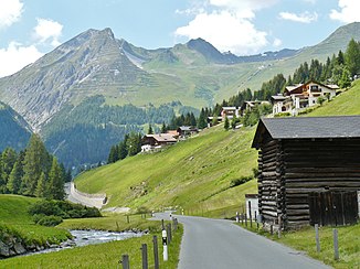
Dischmabach
| Dischmabach | ||
|
The Dischmabach |
||
| Data | ||
| Water code | CH : 299 | |
| location |
Rhaetian Alps
|
|
| River system | Rhine | |
| Drain over | Landwasser → Albula → Hinterrhein → Rhine → North Sea | |
| source | below Scalettahorn 46 ° 41 ′ 36 ″ N , 9 ° 56 ′ 4 ″ E |
|
| Source height | approx. 2800 m above sea level M. | |
| muzzle | Confluence with Landwasser Coordinates: 46 ° 48 ′ 5 ″ N , 9 ° 50 ′ 16 ″ E ; CH1903: 783 112 / 186161 46 ° 48 '5 " N , 9 ° 50' 16" O |
|
| Mouth height | 1543 m above sea level M. | |
| Height difference | approx. 1257 m | |
| Bottom slope | approx. 79 ‰ | |
| length | approx. 16 km | |
| Catchment area | 53.7 km² | |
| Discharge at the Davos gauge , Kriegsmatte A Eo : 42.9 km² |
NNQ (1965) MNQ 1964–2016 MQ 1964–2016 Mq 1964–2016 MHQ 1964–2016 HHQ (1975) |
80 l / s 1.14 m³ / s 1.7 m³ / s 39.6 l / (s km²) 2.2 m³ / s 19.1 m³ / s |
| Discharge at the estuary A Eo : 53.7 km² at the estuary |
MQ Mq |
1.82 m³ / s 33.9 l / (s km²) |
| Part of the main hydrological strand of the Alpine Rhine | ||
|
The Dischmabach in the Dischmatal |
||
|
The Dischma Bach flows into the Landwasser (left) |
||
The Dischmabach is a 15 kilometer long stream in the Albula river system . It is a southeastern and left tributary of the Landwasser and drains the Dischma . Its catchment area is mainly in the area of the Swiss municipality of Davos .
geography
course
The Dischmabach has two equal source brooks. The Dischmabach has its headwaters in the area of the Scalettapass ( Dischmabach source 1 ). The other source stream, the Furggabach , has its source area at the Fuorcla da Grialetsch ( Furggabach source ). Both source streams unite at Dürrboden ( Dischmabach source association ). Then the Dischmabach flows in a north-westerly direction through the elongated and gently sloping Dischma and flows into the Landwasser between Davos-Dorf and Davos-Platz .
Tributaries
Inflows from the source to the mouth with length information in km, catchment area size in km² and the mean discharge (MQ) in m³ / s
- Furggabach ( right ), 3.5 km, 6.35 km², 0.23 m³ / s
- Riinertällibach ( left ), 4.1 km, 4.32 km²
- Rüedisch Tällibach ( Rüedischbach ) ( left ). 3.5 km, 3.04 km²
Hydrology
Main hydrological strand
Within the Hinterrhein system, the sources of the Dischmabach are about 72 km away from the confluence of the Vorder and Hinterrhein rivers. Only the sources of Rein da Medel , Rein da Maighels and Rein da Curnera (around 74–76 km), which belong to the Vorderrhein system, are at a greater distance. Above all, the Furggabach via Dischmabach is the main hydrological branch of the Alpine Rhine , which is formed by the larger (more watery) river at each confluence (see also the source of the Rhine ). The Dischmabach is one of the most important source rivers of the Rhine .
Flood
The mean annual high water of the Dischma brook at the Kriegsmatte gauge is 11.40 m³ / s. The highest annual peak ever recorded was registered in 1975 and was 19.10 m³ / s.
The flood probabilities for the Dischmabach are shown in the following table:
| Annuality (years) | 2 | 5 | 20th | 30th | 50 | 100 |
|---|---|---|---|---|---|---|
| Discharge (m³ / s) | 11 | 14th | 16 | 18th | 19th | 20th |
| Note to HQN: the number corresponding to the high water flow (HQ = H ochwasser q uantität) in m³ / s, which - repeated with the specified return period (n = number of years) - the average. | ||||||
Web links
Individual evidence
- ↑ a b c Geoserver of the Swiss Federal Administration ( information )
- ↑ a b Topographical catchment areas of Swiss waters: area outlets. Retrieved May 26, 2019 .
- ^ " Kriegsmatte" measuring station in Davos 1964–2016 (PDF) Federal Office for the Environment FOEN
- ↑ The length information, catchment area sizes and the values for the mean runoff to swisstopo .
- ↑ Flood probabilities (annual flood), Dischmabach - Davos, Kriegsmatte. (PDF) Federal Office for the Environment FOEN, Hydrology Department, accessed on January 29, 2014 .
- ↑ Measuring point: Davos, Kriegsmatte (2327), on FOEN hydrodata


