
Glenner
|
Glenner Romansh: Glogn |
||
 Glenner near Praden above Ilanz |
||
| Data | ||
| Water code | CH : 292 | |
| location | Graubünden , Switzerland | |
| River system | Rhine | |
| Drain over | Vorderrhein → Rhine → North Sea | |
| source | slightly below the Piz la Capiala 46 ° 34 '53 " N , 9 ° 3' 48" O |
|
| Source height | approx. 2615 m above sea level M. | |
| muzzle | near Ilanz in the Vorderrhein Coordinates: 46 ° 46 '37 " N , 9 ° 12' 46" E ; CH1903: 735 484 / 182172 46 ° 46 '37 " N , 9 ° 12' 46" O |
|
| Mouth height | 688 m above sea level M. | |
| Height difference | approx. 1927 m | |
| Bottom slope | approx. 62 ‰ | |
| length | 31 km | |
| Catchment area | 382.6 km² | |
| Discharge at the Castrisch A Eo gauge : 381 km² Location: 400 m above the mouth |
NNQ (2005) MNQ 1989–2016 MQ 1989–2016 Mq 1989–2016 MHQ 1989–2016 HHQ (1999) |
440 l / s 5.04 m³ / s 8.88 m³ / s 23.3 l / (s km²) 13.7 m³ / s 379 m³ / s |
| Left tributaries | Aua da Darlun, Aua da Blengias, Aua Diesrut, Aua da Cavel, Degenbach | |
| Right tributaries | Aua da Serenastga, Valser Rhein , Val Uastg, Val da Pitasch, Rieinbach | |
| Small towns | Ilanz | |
| Communities | Lumnezia | |
| Navigable | with kayak, lower section | |

| ||
Source and mouth of the Glenner
|
The Glenner (Rhaeto-Romanic: Glogn ) is by far the largest tributary of the Vorderrhein and runs in the Swiss canton of Graubünden . Glenner was also the name of a district of this canton that existed until 2001, the area of which was administratively divided into the Grisons Oberland region of Surselva from 2016 .
course
The wild river has its source near the border with the canton of Ticino . Here it is surrounded by mountains more than 3100 m high ( Piz Terri , 3149 m) and then flows through the Val Lumnezia . In the upper reaches, the river has cut a deep gorge that has black slate in a few places. At Suraua , the Glenner takes on its most important tributary, the Valser Rhine , which is significantly larger in size and length , and flows into the Vorderrhein after a good 10 kilometers at Ilanz . Here it has an average water flow of almost 9 m³ / s; During the snowmelt and after rainfall, the river usually has dark gray water.
bridges
10 road bridges, 7 pedestrian bridges and 1 railway bridge cross the Glenner.
photos

Kayak trip near Pitasch
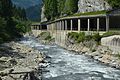
Galleries on Valserstrasse

Glenner flows into the Vorderrhein

Same confluence, looking west


literature
- Martin Arnold, Urs Fitze; WWF: Pearls of water (Kp .: Glenner). At-Verlag Aarau 2018. ISBN 978-3-03800-086-0
Web links
- Glenner on the ETHorama platform
- Adolf Collenberg: Glenner. In: Historical Lexicon of Switzerland .
- River guide online at kajaktour.de
Individual evidence
- ↑ a b Geoserver of the Swiss Federal Administration ( information )
- ↑ Evaluations of the water network. (XLSX) FOEN , December 2013, accessed on August 9, 2017 (listing of Swiss rivers> 30km).
- ↑ Modeled mean annual discharge. In: Topographical catchment areas of Swiss waters: sub-catchment areas 2 km². Retrieved May 30, 2019 .
- ↑ Castrisch measuring station 1989–2016 (PDF) Federal Office for the Environment FOEN
Rivers with a total length of more than 30 km:
Aare |
Albula |
Allaine |
Old Rhine |
Arbogne |
Areuse |
Swiss stone pine |
Birs |
Brenno |
Broye |
Calancasca |
Doubs |
Drance de Bagnes |
Thinning |
Emme |
Engelberger Aa |
Ergolz |
Glâne |
Smooth |
Glenner (Glogn) |
Hinterrhein |
Inn (En) |
Julia (Gelgia) |
Kander |
Little Emme |
Landquart |
Land water |
Langete |
Limmat |
Linth |
Lorze |
Maggia |
Mentue |
Moësa |
Muota |
Murg |
Necker |
Orbe |
Petite Glâne |
Plessur |
Rabiusa |
Reuss |
Rhine |
Rhone |
Saane |
Schüss (Suze) |
Seez |
Scythe |
Sihl |
Simme |
Sitter |
Sorne |
Suhre |
Talent |
Tamina |
Ticino (Ticino) |
Thur |
Töss |
Venoge |
Verzasca |
Vispa |
Vorderrhein |
Wigger |
Wyna