
Suraua
| Suraua | ||
|---|---|---|
 |
||
| State : |
|
|
| Canton : |
|
|
| Region : | Surselva | |
| Political community : | Lumnezia | |
| Postal code : | 7110 Peiden 7114 Uors 7113 Camuns 7115 Surcasti 7148 Tersnaus |
|
| former BFS no. : | 3599 | |
| Coordinates : | 733 427 / 173 569 | |
| Height : | 932 m above sea level M. | |
| Area : | 24.20 km² | |
| Residents: | 238 (December 31, 2012) | |
| Population density : | 10 inhabitants per km² | |
| Website: | www.suraua.ch | |
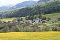
 Surcasti |
||
| map | ||
|
||


Until December 31, 2012, Suraua ( ) was a political municipality in the Lugnez district in the also former Surselva district of the canton of Graubünden in Switzerland .
On January 1, 2013, it merged with the municipalities of Cumbel , Degen , Lumbrein , Morissen , Vignogn , Vella and Vrin to form the new municipality of Lumnezia .
coat of arms
Blazon : In green, a blue, silver (white) bordered sloping wave bar, covered by a gold four-pointed star, woven into a silver ring
The design of the coat of arms of this former merged community emerged from a competition among the former community youth. It shows the geographical location of the former municipality through the river in the green field (forest and pastures) and the merger (ring) of the four former municipalities (star) to form a new whole.
geography
The place is in the Surselva and for historical reasons consists of the fractions Camuns , Surcasti , Tersnaus and the former merged community Uors-Peiden , which was created in 1963 from the merger of Uors and Peiden and lasted until 2002. Camuns is located on the northwest slope of Pala da Tgiern (2205 m) and consists of the districts of Camuns (1177 m), Sutscheins (1176 m), Masauns (1113 m) and Runs (1171 m). To the south-west of it lies Uors (932 m). This was the seat of the former autonomous municipal administration. The clustered village of Tersnaus (1070 m) is located south of Uors at the entrance to the Valser Valley . The northernmost village of this former cooperative community was the village of Peiden (934 m) on the left side of the Glenner . These former, now merged, Graubünden small communities, also called fractions or neighborhoods in the local sense, are located in the Lower Val Lumnezia in the schisty passage area of the Glenner and Valser Rhine . The mountain village of Surcasti is located on a terrace on the wooded northern foothills of the Muttaun (2036 m) and the Wannaspitz (2444 m).
Of the entire former municipal area of 2,420 hectares, 1206 hectares were forested and 408 hectares were mountains. 322 of the 705 hectares of usable agricultural area served as alpine meadows for alpine agriculture. Only the remaining 49 hectares were settlement areas.
population
| Population development | ||
|---|---|---|
| year | 2004 | 2012 |
| Residents | 291 | 238 |
Of the 291 residents at the end of 2004, 282 (= 97%) were Swiss nationals and mainly spoke Romansh.
history
The municipality was created on January 1st, 2002 from the union of the previous municipalities and from 2013 it is part of the new municipality Lumnezia, which was created through the merger .
Uors

Camuns Church
Peiden village church
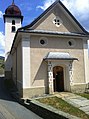
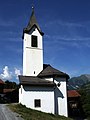
Surcasti Church

Fabulous boulder from Surcasti


Attractions
literature
- The municipalities of the canton of Graubünden. Chur / Zurich, 2003. ISBN 3-7253-0741-5
- Editor: Suraua. In: Historical Lexicon of Switzerland . 2016 .
- Simon Derungs. La historia da Surcasti-Suraua. ProSuraua 2017
- Pierina Caminada et al. Andrea Fischbacher. Places of magic in Val Lumnezia. Zurich 2015
Web links
Individual evidence
- ↑ stiftungswf.ch: Foundation of Swiss coats of arms and flags, mergers and independence of municipalities - Suraua GR , accessed on January 18, 2010
Breil / Brigels | Disentis / Mustér | Falera | Ilanz / Glion | Laax | Lumnezia | Medel (Lucmagn) | Obersaxen Mundaun | Safiental | Sagogn | Schluein | Sumvitg | Trun | Tujetsch | Vals
Former parishes: Andiast | Camuns | Castrisch | Cumbel | Sword | Duvin | Flond | Ilanz | Ladir | Lumbar clean | Luff | Morissen | Mundaun | Obersaxen | Peiden | Pigniu | Pitasch | Riein | Rueun | Ruschein | Safien | Slim | Schnaus | Sculms | Sevgein | Siat | St. Martin | Strada | Suraua | Surcasti | Surcuolm | Tenna | Tersnaus | Uors | Uors-Peiden | Valendas | Vella | Versam | Vignogn | Vrin | Waltensburg / Vuorz
Canton of Graubünden | Regions of the Canton of Graubünden | Municipalities of the Canton of Graubünden