
Morissen
| Morissen | ||
|---|---|---|
 |
||
| State : |
|
|
| Canton : |
|
|
| Region : | Surselva | |
| Political community : | Lumnezia | |
| Postal code : | 7143 | |
| former BFS no. : | 3596 | |
| Coordinates : | 733 251 / 176 902 | |
| Height : | 1337 m above sea level M. | |
| Area : | 5.67 km² | |
| Residents: | 227 (December 31, 2012) | |
| Population density : | 40 inhabitants per km² | |
| Website: | www.lumnezia.ch | |
 Morissen |
||
| map | ||
|
||


Morissen (Romansh Murissen ) was until December 31, 2012 a political municipality in the Val Lumnezia , in the Surselva district of the canton of Graubünden in Switzerland .
On January 1, 2013, it merged with the municipalities of Cumbel , Degen , Lumbrein , Suraua , Vignogn , Vella and Vrin to form the new municipality of Lumnezia in the Surselva region.
coat of arms
Blazon : Three golden (yellow) shells in red
The village church is consecrated to St. James the Elder ; its attribute is the scallop shell.
Surname
The name Morissen appears in different variations in the 12th to 15th centuries: Moraizen , Muraizen , Mureizen , Moreissens , Mureiscen , Moreize or Morainscens . The current name Morissen has been around since 1600. The name is probably derived from the patron saint of Val Lumnezia, the holy Mauritius .
geography
The former municipality of Morissen is located at the entrance to the Val Lumnezia (also known as the Valley of Light in a tourist context) on the left side of the valley on the eastern, sunny slope of Piz Mundaun with a magnificent view of the opposite side of the Lugnez valley. Neighborhoods of Morissen are the villages of Cumbel , Luven , Surcuolm and Vella . The village lies on a geologically unstable slate cover, as does the remaining 25 square kilometer valley slope area of the central Val Lumnezia , which in the main thrust demolition from Vignogn via Vella to Morissen on average moves up to 4 cm down the slope to the valley river Glogn (Glenner). The greatest shifts down the valley are measured below Morissen and Cumbel in the village of Peiden . A downward movement of 13.7 m was measured there from 1887 to 1944, i.e. in 57 years, while the villages above this most active compression and slide zone only moved half as much. Thanks to the less steep slate layer, the soil layers in Morissen were more favorable for building projects, which favored the construction of holiday homes and second homes in recent decades. The favorable hillside location of the village with an imposing view of the magnificent valley landscape also encouraged building and housing activity in the modern age. While the activity of the locals in agriculture declined due to the amalgamation of goods carried out, employment in the tourism, construction and ancillary industries remained stable. The incorporation into the Lumnezia valley community, which was newly formed in 2013, made administrative and general community tasks easier for the residents. A few people find employment as commuters in the vicinity and in the regional center of Ilanz / Glion (city) . The village structure has changed fundamentally since 1960. The growing prosperity (thanks to subsidies) has favored the mechanization of farms and the renovation of the old wooden houses. Many old buildings are now only periodically inhabited second homes or holiday apartments. The historic center of the village lost living space and the native population of the Rhaeto-Romanic language has settled on the outskirts of the village or has migrated. Thanks to initiative residents and support from community contributions and subsidies, the old mill (Romansh: il Mulin) was opened in Morissen in 2017 and the village restaurant was inaugurated as a social meeting place. School locations are Cuschnaus and Vella, to which there are bus connections.
population
| Population development | |||||
|---|---|---|---|---|---|
| year | 1850 | 1900 | 1950 | 2000 | 2012 |
| Residents | 250 | 163 | 297 | 211 | 227 |
In the Federal Population Census in 2000, 91.47% of the residents stated that their mother tongue was Romansh ( Sursilvan ), 6.64% German and 0.95 English. Since 1992 the population has decreased by 4.2%. In 1827 the Yenish families Waser and Amman were accepted as citizens of Morissen. While the Amman died out or moved away, around 400 Waser are still citizens of the former Morissen community. Since 1947 there have been no more water in the community. As in the other valley communities, the large families of the former farms are missing today.
Attractions
- House Collenberg, also called "Schlössli" : the remains of a medieval residential tower can be discovered in the walls. An almost square floor plan with approx. 1.1 m thick walls emerges. The brickwork in stock consists of regular house stones. There are remains of sash windows. There is no documentary evidence of this residential tower. Possibly there was a tavern on the foundation walls, which according to documents had existed in Morissen in the 12th century, or the foundation walls come from a medieval castle of the episcopal vassals of Morissen.
- Village church Sogn Giachen e Sogn Philipp : The church is first mentioned in a document in the indulgence letter for St. Vincentius from 1345 under the patronage of St. James and Christophorus, but the secondary title disappeared as early as 1484. The ecclesiastical emancipation of Pleif began in 1702 with the establishment of a chaplaincy; In 1807 she received the right to baptism and burial, and in 1907 it was elevated to parish status. The first mentioned church from 1345 disappeared in 1484 (according to a report from 1643). The new building of today's church dates from 1868. The altarpiece by Melchior Paul von Deschwanden also dates from this period .
- Sogn Carlo Borromeo church (Sogn Carli) : probably built in the second half of the 17th century, it stands on the eastern slope in a clearing of the Piz Mundaun, on an old road connection from Morissen to Surcuolm . A little further south you will find a chapel with a memorial stone to the founder of the Escherwald.
- Escherwald near St. Carli (Ual da Sogn Carli) : Until the beginning of the 20th century, Lugnez was largely free of forests. In many places the forest was overexploited. The area around Morissen was not spared from this either. The protection of mountain forests and their afforestation later became an issue. In 1874 the reforestation of the Uaul da Sogn Cali, the Escher Forest, took place. On a boulder above the holy niche there is a memorial plaque in honor of Arnold Escher von der Linth , the founder and sponsor of this reforestation. The Escherwald has the character of a forest planted in rows. There are noticeably many trees growing there in the form of Zwiesel (botany) , as one suspects a special energy flow due to the special geological subsoil.
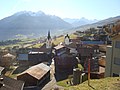
Morissen - village center
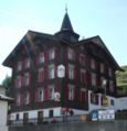
Ustria Piz Mundaun, built in 1886, remodeled in 2018

"Schlössli"

Church of St Jacob and Philipp, mentioned in 1345

Morissen seen from Piz Mundaun
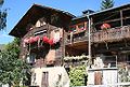
Knitted farmhouse in Morissen


literature
- Adolf Collenberg: Morissen. In: Historical Lexicon of Switzerland . 2017 .
- Duri Blumenthal, Armin Caduff, Curdin Casaulta, Peter Schmid: Kulturführer Val Lumnezia and Vals, Vella 2000.
- Heinrich Jackli. Time scales of the earth's history. Basel 1985, p. 27.
- Pierina Caminada et al. Andrea Fischbacher. Places of magic in Val Lumnezia. Zurich 2015.
Web links
Individual evidence
Breil / Brigels | Disentis / Mustér | Falera | Ilanz / Glion | Laax | Lumnezia | Medel (Lucmagn) | Obersaxen Mundaun | Safiental | Sagogn | Schluein | Sumvitg | Trun | Tujetsch | Vals
Former parishes: Andiast | Camuns | Castrisch | Cumbel | Sword | Duvin | Flond | Ilanz | Ladir | Lumbar clean | Luff | Morissen | Mundaun | Obersaxen | Peiden | Pigniu | Pitasch | Riein | Rueun | Ruschein | Safien | Slim | Schnaus | Sculms | Sevgein | Siat | St. Martin | Strada | Suraua | Surcasti | Surcuolm | Tenna | Tersnaus | Uors | Uors-Peiden | Valendas | Vella | Versam | Vignogn | Vrin | Waltensburg / Vuorz
Canton of Graubünden | Regions of the Canton of Graubünden | Municipalities of the Canton of Graubünden