Tuxtla Gutiérrez
| Tuxtla Gutiérrez | ||
|---|---|---|
|
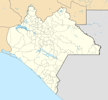
Coordinates: 16 ° 45 ′ N , 93 ° 6 ′ W Tuxtla Gutiérrez on the map of Chiapas
|
||
| Basic data | ||
| Country | Mexico | |
| State | Chiapas | |
| Municipio | Tuxtla Gutiérrez | |
| Residents | 537,102 (2010) | |
| City insignia | ||
| Detailed data | ||
| height | 520 m | |
| Website | ||
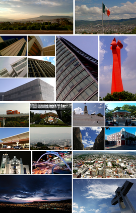
| Photo mosaic by Tuxtla Gutiérrez | ||
Tuxtla Gutiérrez ( Spanish pronunciation: [ ˈtustla ɣuˈtjeres ]) is the capital of the Mexican state of Chiapas, with a population of around 500,000 . The city is the seat of the Archdiocese of Tuxtla Gutiérrez .
location
Tuxtla Gutiérrez is located in the basin of the Río Grijalva at an altitude of about 520 m above sea level. d. M. The city of Chiapa de Corzo , which was founded in the colonial era, is located about 15 km southeast.
Surname
The name Tuxtla comes from Nahuatl and means something like "place of the many rabbits". The nickname Gutiérrez honors Joaquín Miguel Gutiérrez Canales , a Mexican politician of the 19th century.
population
The city's population is a mixture of Indians, Europeans and mestizos. Accordingly, both Indian languages and Spanish are spoken.
Economy and Infrastructure
The economy of Tuxtlas consists primarily of small trade and craft businesses; in addition, it depends to a large extent on the local authorities, according to the federal state administration. There is almost no industry and, unlike the rest of Chiapas, many luxury shops.
In terms of road technology, Tuxtla Gutiérrez is comparatively well developed across the region by the Carretera Panamericana (Pan-American motorway Mexico 190), a trunk road from Tuxtla to Coatzacoalcos , the Carretera al Pacífico road and seven local highways.
In terms of aviation technology, Tuxtla Gutiérrez is regularly connected by various airlines with several other destinations in Mexico and has been added to the dense domestic flight network of Interjet and Aeroméxico . In 2006 the newly built Tuxtla Gutiérrez airport was opened, replacing the city's old airport. It is located southeast of the city in the neighboring city of Chiapa de Corzo .
Tuxtla Gutiérrez has no rail connection. The nearest train station is in Arriaga , around 190 kilometers away. The nearest port is around 200 kilometers away and is located in Puerto Arista .
history
In pre-Hispanic times there were several smaller settlements of the Zoque and Chiapa Indians, all of which were subjugated by the Aztecs in the years 1486–1505 . The former name Coyatoc was translated into the equivalent Tuchtlán . After the conquest of the Aztec Empire by Hernán Cortés in 1519–1521, the Spaniards tried to bring the Aztec- conquered areas under their control, but in the case of central Chiapas only in 1528 with a separate campaign under the leadership of the conquistador Diego de Mazariegos succeeded. However, San Marcos Tuxtla, as the Spanish called the place, was for a long time in the shadow of the neighboring Chiapa de Corzo and only gradually gained in importance after the creation of two judicial and administrative zones ( alcadías ) in 1768 and received city rights in 1813 and 1829 respectively .
Attractions
The relatively modern city has few attractions; particular mention should be up to the colonial time apse newly built Catedral San Marcos , the zoo and the 1984 inaugurated Museo Regional de Antropologia e Historia , in which the most important archaeological finds of the region have been collected.
Surroundings: In the vicinity of Tuxtla are the town of Chiapa de Corzo and the Cañón del Sumidero , which is up to 1200 m deep and 60 km long and begins about 10 km north of Tuxtla.
sons and daughters of the town
- Juan Bañuelos (1932–2017), poet, essayist, editor and university professor
- Sergio Mota Marín (* 1941), ambassador
- Rodulfo Figueroa Aramoni (* 1942), former ambassador
- Miguel Ángel Casanova Díaz (* 1980), former football player


