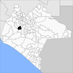
Municipio of Tuxtla Gutiérrez
| Tuxtla Gutiérrez | |
|---|---|

|
|
| Basic data | |
| Country | Mexico |
| State | Chiapas |
| Seat | Tuxtla Gutiérrez |
| surface | 336.1 km² |
| Residents | 553,374 (2010) |
| density | 1,646.6 inhabitants per km² |
| founding | 1915 |
| Website | tuxtla.gob.mx |
| INEGI no. | 07101 |
| politics | |
| Presidente municipal | Luis Fernando Castellanos Cal y Mayor |
| View of the city of Tuxtla Gutiérrez | |
Coordinates: 16 ° 45 ′ N , 93 ° 6 ′ W
Tuxtla Gutiérrez is a municipality in the Mexican state of Chiapas . The municipality has about 550,000 inhabitants and an area of 336 km². The administrative seat and largest place in the municipality is Tuxtla Gutiérrez of the same name , which is also the capital of the state.
The municipality of Tuxtla Gutiérrez forms the core of the Zona Metropolitana de Tuxtla Gutiérrez .
geography
The municipality of Tuxtla Gutiérrez is centrally located in the Mexican state of Chiapas at heights between 200 m and 1500 m . It belongs entirely to the physiographic province of the Sierra Madre de Chiapas and is entirely in the hydrological region of Grijalva - Usumacinta . The geology of the municipality is determined by 38% limestone - lutite with 25% limestone, 20% alluvion and 12% silty sandstone ; The predominant soil types are Leptosol (38%), Regosol (18%), Vertisol (17%) and Luvisol (11%). About 41% of the community area is urbanized, 30% is forested, 23% is used for arable farming.
The municipality of Tuxtla Gutiérrez borders the municipalities of San Fernando , Osumacinta , Chiapa de Corzo , Suchiapa , Ocozocoautla de Espinosa and Berriozábal .
population
The 2010 census counted 553,374 people in 141,903 residential units in the municipality. Of these, 11,252 people were registered as speakers of an indigenous language , including 4,249 speakers from Tzotzil and 3,927 speakers from Tzeltal . A good five percent of the population was illiterate. 244,282 residents were registered as economically active, of which approx. 61% were men and 3% were unemployed. Eight percent of the population lived in extreme poverty.
places
The municipality of Tuxtla Gutiérrez comprises 115 inhabited localidades , of which the main town as well as Copoya and El Jobo are classified as urban by the INEGI . Four towns had a population of over 500 in the 2010 census, 105 towns had fewer than 100 inhabitants. The biggest places are:
| place | Residents |
| Tuxtla Gutiérrez | 537.102 |
| Copoya | 8,160 |
| El Jobo | 4,632 |
| Emiliano Zapata ( Agua Fría ) | 861 |
Web links
- Enciclopedia de los Municipios y Delegaciones de México: Municipio Tuxtla Gutiérrez (Spanish)
- INEGI : Datos Geográficos: Municipio Tuxtla Gutiérrez (Spanish; PDF)

