Municipio Cintalapa
| Cintalapa | |
|---|---|

|
|
| Basic data | |
| Country | Mexico |
| State | Chiapas |
| Seat | Cintalapa de Figueroa |
| surface | 2,404.6 km² |
| Residents | 78,114 (2010) |
| density | 32.5 inhabitants per km² |
| founding | 1915 |
| INEGI no. | 07017 |
| politics | |
| Presidente municipal | Antonio Valdez Meza |
| Cintalapa de Figueroa | |
Coordinates: 16 ° 41 ′ N , 93 ° 43 ′ W
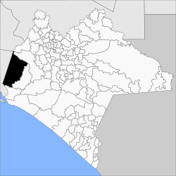
Cintalapa is a municipality in the far west of the Mexican state Chiapas . It is on the edge of the Sierra Madre de Chiapas . The name of this place comes from the Nahuatl and means "water in the subsoil".
The municipality has about 78,000 inhabitants and is 2,404.6 km² in size. The administrative center and largest city in the municipality is Cintalapa de Figueroa . Cintalapa borders the municipalities of Tecpatán , Ocozocoautla de Espinosa , Jiquipilas and Arriaga and the states of Oaxaca and Veracruz .
Web links
- Enciclopedia de los Municipios y Delegaciones de México: Municipio Cintalapa (Spanish)
- INEGI : Datos Geográficos: Municipio Cintalapa (Spanish; PDF)
- El Portal de Chiapas: Map of the municipality (PDF; 18.0 MB)

