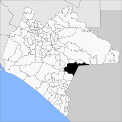
Municipio La Trinitaria
| La Trinitaria | |
|---|---|

|
|
| Basic data | |
| Country | Mexico |
| State | Chiapas |
| Seat | La Trinitaria |
| surface | 1,608.4 km² |
| Residents | 72,769 (2010) |
| density | 45.2 inhabitants per km² |
| Website | latrinitaria.gob.mx |
| INEGI no. | 07099 |
| politics | |
| Presidente municipal | Ervin Leonel Pérez Alfaro |
| Landscape in the municipality of La Trinitaria | |
Coordinates: 16 ° 7 ′ N , 92 ° 2 ′ W
La Trinitaria is a municipality in the south of the Mexican state Chiapas . The municipality has about 73,000 inhabitants and an area of 1608.4 km². The administrative seat and largest town of the municipality is La Trinitaria of the same name .
The municipality has a share in the Lagunas de Montebello National Park .
geography
The municipality of La Trinitaria is located in the southeast of the Mexican state Chiapas at heights between 400 m and 1900 m . It is almost entirely part of the physiographic province of the Sierra Madre de Chiapas and lies entirely in the hydrological region of Grijalva - Usumacinta . The geology of the municipality is determined by 61% limestone with 17% limestone lutite and 14% alluvion ; the predominant soil types are Phaeozem (27%), Luvisol (24%), Leptosol (23%) and Vertisol (16%). About 47% of the community area is forested, a good 29% is used by arable land, 22% is used as pasture land.
The municipality of La Trinitaria borders the municipalities Frontera Comalapa , Socoltenango , Tzimol , Comitán de Domínguez , La Independencia and Las Margaritas as well as the Republic of Guatemala .
population
In the 2010 census, 72,769 people in 16,723 residential units were counted in the municipality. Of these, 6,759 people were registered as speakers of an indigenous language , including 2,543 speakers of Kanjobal , 1,798 speakers of Awakatec and 1,014 speakers of Chuj . A good 18 percent of the population was illiterate. 24,256 inhabitants were registered as economically active, of which 90.5% were men and 0.6% were unemployed. A good 37% of the population lived in extreme poverty.
places
The municipality of La Trinitaria comprises 415 inhabited localidades , of which the main town as well as Lázaro Cárdenas, José María Morelos and La Esperanza are classified as urban by the INEGI . In the 2010 census, 16 towns had a population of over 1000, 308 towns had fewer than 100 inhabitants. The biggest places are:
| place | Residents |
| La Trinitaria | 9042 |
| Lázaro Cárdenas | 3699 |
| José María Morelos | 2601 |
| La Esperanza | 2549 |
| El Porvenir Agrarista | 2468 |
| Miguel Hidalgo | 2428 |
| Rodulfo Figueroa | 2321 |
| Las Delicias | 2121 |
| La Gloria | 1874 |
| Álvaro Obregón | 1790 |
| Tziscao | 1562 |
| El Progreso | 1399 |
| Santa Rita | 1389 |
| Nueva Libertad ( El Colorado ) | 1182 |
| Chihuahua | 1088 |
| Unión Juarez | 1050 |
| Carmen Xhan | 982 |
Web links
- Enciclopedia de los Municipios y Delegaciones de México: Municipio La Trinitaria (Spanish)
- INEGI : Datos Geográficos: Municipio La Trinitaria (Spanish; PDF)

