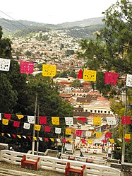
Municipio of San Cristóbal de las Casas
| San Cristobal de las Casas | ||
|---|---|---|

|
||
| Symbols | ||
|
||
| Basic data | ||
| Country | Mexico | |
| State | Chiapas | |
| Seat | San Cristobal de las Casas | |
| surface | 395.5 km² | |
| Residents | 185,917 (2010) | |
| density | 470.1 inhabitants per km² | |
| founding | 1915 | |
| Website | sancristobal.gob.mx | |
| INEGI no. | 07078 | |
| politics | ||
| Presidente municipal | Jerónima Toledo Villalobos | |
| San Cristobal de las Casas | ||
Coordinates: 16 ° 44 ′ N , 92 ° 38 ′ W
San Cristóbal de las Casas is a municipality in the center of the Mexican state Chiapas . The municipality has about 186,000 inhabitants and an area of 395.5 km². The administrative seat and largest city of the municipality is the Pueblo Mágico San Cristóbal de las Casas of the same name .
geography
The municipality of San Cristóbal de las Casas consists of a main part around the city of the same name and an exclave around the place Napite further east. The municipality is centrally located in the Mexican state of Chiapas at altitudes between 800 m and 2800 m . It belongs entirely to the physiographic province of the Sierra Madre de Chiapas and is entirely in the hydrological region of Grijalva - Usumacinta . The geology of the municipality is 82% limestone with 6% alluvion ; The predominant soil types are Alisol (47%), Luvisol (38%) and Leptosol (10%). About 51% of the community area is forested, 26% is used for agriculture, 14% is used for pasture land.
The main part of the Municipio San Cristóbal de las Casas borders on the Municipios Chamula , Tenejapa , Huixtán , Teopisca , Totolapa , San Lucas and Zinacantán , the exclave borders on the Municipios Huixtán, Chanal , Amatenango del Valle and Teopisca.
population
The 2010 census counted 185,917 people in 40,714 residential units in the municipality. Of these, 62,208 people were registered as speakers of an indigenous language , of which 43,302 speakers from Tzotzil and 15,440 speakers from Tzeltal . A good 13 percent of the population was illiterate. 74,452 inhabitants were registered as economically active, of which 63% were men and 2.5% were unemployed. A good 21% of the population lived in extreme poverty.
places
The municipality of San Cristóbal de las Casas comprises 98 inhabited localidades , of which only the main town is classified as urban by the INEGI . In the 2010 census, five towns had a population of over 1000, while 31 towns had fewer than 100 inhabitants. The biggest places are:
| place | Residents |
| San Cristobal de las Casas | 158.027 |
| San Antonio del Monte | 2,196 |
| La Candelaria | 1,955 |
| Mitzitón | 1,293 |
| Yashitinín ( San José Yashitinín ) | 1.109 |
| El Pinar | 931 |
| Zacualpa Ecatepec | 885 |
Web links
- Enciclopedia de los Municipios y Delegaciones de México: Municipio San Cristóbal de las Casas (Spanish)
- INEGI : Datos Geográficos: Municipio San Cristóbal de las Casas (Spanish; PDF)


