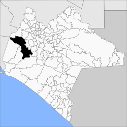
Municipio Ocozocoautla de Espinosa
| Ocozocoautla de Espinosa | |
|---|---|

|
|
| Basic data | |
| Country | Mexico |
| State | Chiapas |
| Seat | Ocozocoautla de Espinosa |
| surface | 2,102.5 km² |
| Residents | 82,059 (2010) |
| density | 39 inhabitants per km² |
| founding | 1915 |
| INEGI no. | 07061 |
| politics | |
| Presidente municipal | Alfonso Estrada Pérez |
| San Bernabé Chapel in Ocozocoautla de Espinosa | |
Coordinates: 16 ° 46 ′ N , 93 ° 22 ′ W
Ocozocoautla de Espinosa is a municipality in the Mexican state of Chiapas . The municipality has about 82,000 inhabitants and an area of 2102.5 km². The administrative seat and largest place of the municipality is the eponymous Ocozocoautla de Espinosa .
The name Ocozocoautla comes from Nahuatl and means 'Ocozote Forest' (Ocozote is a type of textile), the addition Espinosa honors the revolutionary Luis Espinosa .
Parts of the municipality form the Selva El Ocote biosphere reserve . In the north, the municipality has a share of the Nezahualcóyotl reservoir .
geography
The municipality of Ocozocoautla de Espinosa is located in the west of the Mexican state Chiapas at heights between 100 m and 1800 m . 96% of it belongs to the physiographic province of the Sierra Madre de Chiapas and four percent to the Cordillera Centroamericana ; it is entirely located in the Grijalva - Usumacinta hydrological region . The geology of the municipality is determined by 65% limestone with 15% sandstone - lutite , 8% limestone-lutite, 6% granite and 5% alluvion ; the predominant soil types are Luvisol (41%), Leptosol (36%) and Alisol (7%). About 58% of the community area is forested, 25% is used for pasture land, 10% is used for arable farming.
The municipality of Ocozocoautla de Espinosa borders the municipalities of Mezcalapa , Tecpatán , Berriozábal , Tuxtla Gutiérrez , Suchiapa , Villaflores , Jiquipilas and Cintalapa .
population
The 2010 census counted 82,059 people in 18,156 residential units in the municipality. Of these, 13,260 people were registered as speakers of an indigenous language , including 12,134 speakers of the Tzotzil . Almost 16 percent of the population were illiterate. 28,821 inhabitants were registered as economically active, of which almost 80% were men and 1.2% were unemployed. Over 37% of the population lived in extreme poverty.
places
The Municipio Ocozocoautla de Espinosa comprises 708 inhabited localidades , of which the main town and Ocuilapa de Juárez are classified as urban by the INEGI . Eight towns had at least 1000 inhabitants, 628 towns had fewer than 100 inhabitants. The biggest places are:
| place | Residents |
| Ocozocoautla de Espinosa | 39,180 |
| Ocuilapa de Juarez | 3,921 |
| Vicente Guerrero ( Matamoros ) | 2,009 |
| Guadalupe Victoria | 1,876 |
| Ignacio Zaragoza ( El Morro ) | 1,675 |
| La Independencia ( Las Pilas ) | 1,178 |
| Hermenegildo Galeana | 1,068 |
| Alfonso Moguel | 1,022 |
| CNC | 940 |
Web links
- Enciclopedia de los Municipios y Delegaciones de México: Municipio Ocozocoautla de Espinosa (Spanish)
- INEGI : Datos Geográficos: Municipio Ocozocoautla de Espinosa (Spanish; PDF)

