Coatzacoalcos
| Coatzacoalcos | ||
|---|---|---|
|
Coordinates: 18 ° 8 ′ N , 94 ° 26 ′ W Coatzacoalcos on the map of Veracruz
|
||
|
Location of Coatzacoalcos in the isthmus of Tehuantepec
|
||
| Basic data | ||
| Country | Mexico | |
| State | Veracruz | |
| Municipio | Coatzacoalcos | |
| City foundation | 1520 | |
| Residents | 235,983 (2010) | |
| City insignia | ||
| Detailed data | ||
| height | 25 m | |
| Post Code | 96380 | |
| Port and city in 1904 | ||
| View from a river ferry over the city and the estuary of the Río Coatzacoalcos | ||
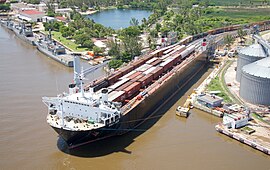
| Railway ferry in the harbor | ||
Coatzacoalcos is a port city with around 250,000 inhabitants in the southeast of the Mexican state of Veracruz . The city is the administrative seat of the municipality and diocese of the same name .
geography
location
The port city of Coatzacoalcos is located at a height of approx. 25 m in the north of the isthmus of Tehuantepec at the confluence of the Río Coatzacoalcos in the Gulf of Mexico and is almost 600 km (driving distance) in a southeast direction from Mexico City ; Veracruz , the former capital of the state, is a good 300 km to the northwest.
geology
The soils of the municipality are partly of volcanic origin and were deposited during earlier eruptions of the volcanoes of the Sierra de los Tuxtlas ; on the other hand, they consist of the alluvial land of the Río Coatzacoalcos.
climate
The climate is humid and warm for most of the year: the daytime temperatures are rarely below 25 ° C, but also rarely exceed 32 ° C; Rain (approx. 2470 mm / year) falls mainly in the second half of the year. The humidity is extremely high in the entire state of Veracruz and is usually between 70 and 80%. Sometimes arise in the Atlantic cyclones ( hurricanes ) that can afflict the Mexican Gulf Coast.
Population development
| year | 1900 | 1950 | 2000 |
| Residents | 2,937 | 19,501 | 225,973 |
The city's sustained population growth is largely due to the influx of people from the surrounding countryside.
economy
The city itself now serves primarily as a residential area and only has smaller port facilities; the significant Überseehafen is Minatitlán on the opposite side of the river. This was expanded in the years 1899 to 1907 after a railway line had been opened through the isthmus of Tehuantepec , which connected Coatzacoalcos with Salina Cruz on the Pacific Ocean . The petrochemical industry is primarily located in and around Minatitlán .
Infrastructure
The cable-stayed bridge over the Río Coatzacoalcos, completed in 1980, is one of the landmarks of modern Mexico with a total length of 1170 m and a pillar height of approx. 100 m. Only about two kilometers further north is a four-lane 2.3 km long (about 700 m below the river) road tunnel shortly before its completion, which connects the city on the western bank of the river at a maximum depth of 30 m (about 10 m below the deepened river bed) with the port and the industrial zone of Minatitlán on the east side. There is also an international airport south of Minatitlán.
history
The favorable location on a lake-like broadened estuary, which offered good fishing opportunities, makes it probable that the place was settled long before the first advanced cultures of Mesoamerica (see Olmecs ). The Spanish conquered it in the 1520s; The approximately 700 m wide and 28 km long estuary of the Río Coatzacoalcos proved - as Hernán Cortés also noted in a letter to Charles V - to be an economically and strategically favorable and protected port. Cortés founded the city of Villa del Espíritu Santo on the opposite bank of the river . The area subsequently proved to be largely peaceful and thus became an important station in the further advance of the Spaniards in southern Mexico (states of Veracruz , Tabasco and Oaxaca ).
After the independence of Mexico (1821) and the imperial interlude of Maximilian (1864-1867), Coatzacoalcos received city rights in 1881. In 1900 the name of the city was changed to Puerto México to emphasize the special importance of the port for the country; In 1936 it was renamed Coatzacoalcos. In 1984 the city was made a bishopric by Pope John Paul II .
Legend
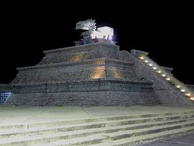
The name of the city means in Nahuatl , the language of the native Indians : "The place where the snake disappeared." It refers to the legend of the flight or emigration of the god-king Quetzalcoatl across the sea. Both the city coat of arms and the museum pyramid refer to it.

Attractions
- During the excavations for the new tunnel, an abundance of ceramic shards came to light, which - according to the archaeologists - can be assigned to different cultural epochs and cultures ( Olmecs , Maya , Totonaks, etc.).
- The Museo de Arqueología is housed in the "pyramid" on the embankment ( Malecón ) and shows over 900 smaller exhibits on the history, art and culture of the Olmecs .
- The old San José Cathedral , a two-tower structure from the 1940s, was demolished in late 2012. As early as 1984, a modern new building in the form of a huge Mayan vault was inaugurated right next to it .
- The Palacio Municipal is a building from the 1950s and rises in the city center.
- The Parque Independencia is located directly in front of the Palacio Municipal and is used by the population - especially in the evening hours - to stroll and promenade.
Personalities
- Malinche (around 1505, † around 1529), interpreter and lover of the Spanish conqueror Hernán Cortés
- Maria Antonieta Collins (* 1951), journalist
- Salma Hayek (born 1966), actress
- Olivia Gorra (* 1971), soprano
Twin cities
-
 San Fernando , Philippines
-
 Shandong , People's Republic of China
-
 Rizhao , Jiangsu , People's Republic of China
-
 Villahermosa , Tabasco , Mexico
 -
 Salina Cruz , Oaxaca , Mexico
 -
 Tuxtla Gutiérrez , Chiapas , Mexico
Web links
- Tourist information about the city (Spanish)
- Photos and tourist information about the city (Spanish)


