
Riein
| Riein | ||
|---|---|---|
 |
||
| State : |
|
|
| Canton : |
|
|
| Region : | Surselva | |
| Political community : | Ilanz / Glion | |
| Postal code : | 7128 | |
| former BFS no. : | 3579 | |
| Coordinates : | 737 116 / 178565 | |
| Height : | 1270 m above sea level M. | |
| Area : | 15.88 km² | |
| Residents: | 66 (December 31, 2013) | |
| Population density : | 4 inhabitants per km² | |
| Website: | www.ilanz-glion.ch/fraktionen/rueun.html | |
 Riein, Cresta hill with castle site on the left |
||
| map | ||
|
||


Riein ( ) was a political municipality near Ilanz in the former Surselva district of the Swiss canton of Graubünden until December 31, 2013 . On January 1, 2014, Riein merged with the former municipalities of Castrisch , Duvin , Ilanz , Ladir , Luven , Pigniu , Pitasch , Rueun , Ruschein , Schnaus , Sevgein , Siat to form the new municipality of Ilanz / Glion .
coat of arms
Blazon : Three black balls in silver (white)
Takeover of the coat of arms of the Lords of Riein.
Geography and traffic
The village is located in the Val Lumnezia (Lugnez) east of the Glenner river on a terrace on the western slope of the Signina group. The former municipal area includes Piz Riein ( 2752 m above sea level ), Piz Signina ( 2848 m above sea level ) and, as the highest mountain, Piz Fess ( 2880 m above sea level ). The two largest settlements are the village of Riein and the district of Signina ( 1318 m above sea level ). Of the entire former municipal area of 1,582 hectares, 631 hectares are unproductive areas (mostly mountains). Another 589 hectares are covered by forest and wood. Almost 70% of the agricultural area of 347 hectares is used as alpine pastures. The rest of 15 ha is settlement area.
The main road leads through a geologically sloping area to the regional center in Ilanz and is often difficult to maintain in winter and is occasionally interrupted. There is a post bus service from Ilanz to Sevgein and Riein.
history
Riein was mentioned in 765 as Renino and in 960 as Raine . Prehistoric grave finds and a shell stone on Alp Plaun da morts indicate early settlement. The royal church mentioned in 840 passed to the diocese of Chur in 960.
The Montalta-Cresta castle site (around 1227) on the Cresta hill on the southern edge of the village was probably the seat of the lords of Montalt (a) -Cresta von Riein (Regins) mentioned in 1325. The episcopal vassal family also served in other Rhaetian castles in the Middle Ages, including Löwenberg Castle (Graubünden) near Schluein. The presumed castle site in Riein is an elongated, distinctive spur with clear flattening and terracing towards the south, but without visible traces of the wall. There are no archaeological excavations. A second, presumed castle site is located south of Sevgein below Riein near Prada, where isolated parts of the wall were found in earlier excavations.
Riein belonged to the former judicial community Gruob (today the Surselva region ) in the Gray League with Sagogn as the main town, which was replaced by Ilanz at the end of the Middle Ages. In the possession of the Chur bishop since 1483 , Gruob bought himself free due to the Ilanz articles in 1538. In 1526 Riein joined the Reformation. The Reformation was rejected by some of the Gruober parishes. During the Sagensian trade around 1700, this led to a brief separation of the Catholic villages.
Riein was almost completely destroyed by village fires in 1879 and 1880. Agriculture (cattle and alpine farming) is still the most important branch of business today.
Signina
The Signina district is an originally Rhaeto-Romanic settlement that was settled by the Walsers in the 15th century . After the village fire of 1879, the children of Riein had to go to school in Signina. This led to a rapprochement of the previously independent faction and in 1904/05 to the incorporation with Riein. The district, cut off by two deep ravines (Val da Cabiena, Val da Riein), has no road and can only be reached from Riein via a one-hour footpath through the ravine or, since 1974, with the pillarless, four -seater Pardi-Signina cable car . The Maiensäss is only inhabited by one farming family all year round. In summer you can hike from there through a schisty Bachtobel to Riein.
population
| Population development | ||||||
|---|---|---|---|---|---|---|
| year | 1850 | 1900 | 1950 | 2000 | 2004 | 2013 |
| Residents | 218 | 169 | 126 | 71 | 65 | 66 |
At the end of 2004, all of the 65 residents were Swiss citizens . The official and school language is Romansh; 63% of the population spoke the idiom Sursilvan in 2000 . The hamlet of Signina belonging to Riein, on the other hand, was inhabited by German-speaking Walsers for centuries . The population is reformed .
The households in Riein are supplied with electricity by a small hydropower plant.
Sights, tourism, culture
The reformed village church is a listed building. The Maiensäss landscape and the magnificent panorama of the Lugnezertal and the Surselvian mountains are attractive. The old, electrically operated wood sawmill from the 1940s was renovated and used for community purposes as well as for seminars and workshops.
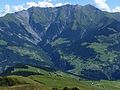
Signina group with Riein and Signina on the left in the middle of the picture
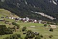
Riein

Village church

Coat of arms on a house in Riein

The Signina group with Piz Riein on the left

Signina, in the background Riein


literature
- Martin Bundi: Riein. In: Historical Lexicon of Switzerland . 2016 .
- The municipalities of the canton of Graubünden. Rüegger, Chur / Zurich 2003, ISBN 3-7253-0741-5 .
Web links
Individual evidence
- ^ Message from the government to the Grand Council of the Canton of Graubünden, No. 5 2014
- ↑ Otto Paul Clavadetscher, Werner Meyer: Das Burgenbuch von Graubünden . Orell Füssli publishing house, Zurich 1984, ISBN 978-3-280-01319-9
- ↑ Alternative hiking: Graubünden mountain railways
- ↑ Alpiq: Riein drinking water power station ( Memento of the original dated August 27, 2014 in the Internet Archive ) Info: The archive link was inserted automatically and has not yet been checked. Please check the original and archive link according to the instructions and then remove this notice.
- ↑ Sagi Riein
Breil / Brigels | Disentis / Mustér | Falera | Ilanz / Glion | Laax | Lumnezia | Medel (Lucmagn) | Obersaxen Mundaun | Safiental | Sagogn | Schluein | Sumvitg | Trun | Tujetsch | Vals
Former parishes: Andiast | Camuns | Castrisch | Cumbel | Sword | Duvin | Flond | Ilanz | Ladir | Lumbar clean | Luff | Morissen | Mundaun | Obersaxen | Peiden | Pigniu | Pitasch | Riein | Rueun | Ruschein | Safien | Slim | Schnaus | Sculms | Sevgein | Siat | St. Martin | Strada | Suraua | Surcasti | Surcuolm | Tenna | Tersnaus | Uors | Uors-Peiden | Valendas | Vella | Versam | Vignogn | Vrin | Waltensburg / Vuorz
Canton of Graubünden | Regions of the Canton of Graubünden | Municipalities of the Canton of Graubünden