
Waltensburg / Vuorz
| Waltensburg / Vuorz | ||
|---|---|---|
 |
||
| State : |
|
|
| Canton : |
|
|
| Region : | Surselva | |
| Political community : | Breil / Brigels | |
| Postal code : | 7158 | |
| former BFS no. : | 3616 | |
| Coordinates : | 728 093 / 182127 | |
| Height : | 1003 m above sea level M. | |
| Area : | 32.31 km² | |
| Residents: | 333 (December 31, 2016) | |
| Population density : | 10 inhabitants per km² | |
| Website: | www.breil.ch | |
 View from the east. Andiast at the top right |
||
| map | ||
|
||


Waltensburg / Vuorz (German and until 1943 officially Waltensburg, Rhaeto-Romanic Vuorz , also Uors la Foppa ) has been part of the municipality of Breil / Brigels in the Surselva region of the Swiss canton of Graubünden since 2018 . Until December 31, 2017, it formed an independent political municipality .
coat of arms
Blazon : In silver (white) on a black horse, knight Georg with gold nimbus and red cloak, killing a green dragon
In the colors of the Upper Confederation , the coat of arms shows Saint George , patron of the church and namesake of Jörgenberg Castle , the location of the church. The motif also showed the community seal .
Place name
The German name Waltensburg (first documented as Waltramsburc in 1208 ) is originally a name for the Jörgenberg Castle, which is located in the municipality. Waltram is an Old High German man's name who made waltan "rule, dominate" and Hraban "Raven" is composed. The Romansh name Vuorz (first attested in 765 as in Vorce ) goes back to the Middle Latin b mittfurcus "forked" and refers to the confluence of the Flem and Schmuer streams near the village. In written language up to the recent past and dialectally still today, the place name is Uors or Uors la Foppa, in contrast to Uors la Lumnezia .
geography
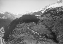
The street village Waltensburg is located in the Surselva on a hillside terrace on the southern slope of the Vorderrhein Valley. A small part of the community and the train station is on the right side of the Vorderrhein . Most of the municipality is on the left, where it rises from Run Dado (745 m) up to Ruchi (3107 m). The northern municipal border is also the canton border to Glarus and consists of a mountain range to which the Muttenstock (3,089 m) belongs in addition to the Ruchi . The Piz d'Artgas (2787 m) rises a little further south . In addition to the village, the community includes the hamlet of Tavellas and numerous individual farms.
Of the entire municipal area of over 32 km², 1291 ha (= 49%) of mountains and 712 ha (= 22%) are forested. 864 hectares of the 1181 hectares of arable land are claimed by Maiensässen. The remaining 48 hectares of the municipal area are settlement areas.
population
| Population development | ||||||||||
|---|---|---|---|---|---|---|---|---|---|---|
| year | 1850 | 1900 | 1950 | 1980 | 2000 | 2004 | 2010 | 2012 | 2014 | 2016 |
| Residents | 443 | 362 | 406 | 322 | 383 | 393 | 364 | 349 | 343 | 333 |
Of the 393 residents at the end of 2004, 376 were Swiss nationals. Waltensburg has been a Reformed exclave in the otherwise almost exclusively Catholic Surselva since the 16th century .
The official language is Romansh in the Sursilvan version .
Attractions

- The Reformed Church of Waltensburg was built in the 11th century as a chapel in the shape of a hall.
Of the wall paintings from four different epochs, the works of an unknown master around 1330 are particularly valuable in terms of art history. Because he left his most important works in Waltensburg, he is called the Waltensburg Master . His works are spiritually related to the miniatures of the Manessian manuscript that were made around the same time, as well as the stained glass from Königsfelden .
- House Cadonau-Dalbert (Casa Cadonau-Dalbert)
- House Wieland (Casa Wieland)
The ruins of four castles are in Waltensburg:
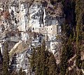
- In the eastern part of the village are the ruins of Jörgenberg Castle . It is first mentioned in 765 in Bishop Tello's will.
- The Grünenfels Castle (Rom. Chischlatsch), seat of the lords of the same name in the 13th century, is practically in the center of the village .
- The Kropfenstein Castle is west of the village on a vertical rock face and the Burg Vogelsberg (rom. Cafoghel) above the road to Andiast .
The Senda Sursilvana , a long-distance hiking trail along the young Rhine , leads from the Oberalp Pass through the northern neighboring town of Andiast in the direction of Chur, in keeping with the tranquility of the location far above the valley floor and through traffic.
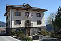
Parish hall
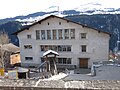
school

Reformed Church (after restoration in 2009/10)

Interior of the church

Ruin Jörgenberg
Kropfenstein ruin


literature
- Martin Bundi: Waltensburg / Vuorz. In: Historical Lexicon of Switzerland . 2014 .
- Die Südostschweiz (Ed.): The municipalities of the canton of Graubünden. Rüegger, Chur u. a. 2003, ISBN 3-7253-0741-5 .
- U. Caflisch: Art Guide Evangelical Church Waltensburg / Vuorz. Edited by the rectory in Waltensburg / Vuorz and the Waltensburg / Vuorz-Andiast tourist office. Without a year [1980; 2nd edition 1994].
- Willy Zeller: Art and culture in Graubünden. Illustrated guide. 3. Edition. Haupt-Verlag, Bern u. a. 1993, ISBN 3-258-04759-6 .
- Horst F. Rupp (ed.): The Waltensburg master in his time. Kunstverlag Josef Fink, Lindenberg i. A. / Verlag Bündner Monatsblatt, Chur 2015, ISBN 978-3-905342-51-2 .
Web links
- Waltensburg / Vuorz on the ETHorama platform
- Official website of the Brigels-Waltensburg-Andiast tourist region
Individual evidence
- ↑ a b Lexicon of Swiss municipality names . Edited by the Center de Dialectologie at the University of Neuchâtel under the direction of Andres Kristol. Frauenfeld / Lausanne 2005, p. 953.
- ^ Martin Bundi : Waltensburg / Vuorz. In: Historical Lexicon of Switzerland . December 27, 2014 , accessed June 6, 2019 .
- ↑ Waltram
- ↑ Senda Sursilvana
Breil / Brigels | Disentis / Mustér | Falera | Ilanz / Glion | Laax | Lumnezia | Medel (Lucmagn) | Obersaxen Mundaun | Safiental | Sagogn | Schluein | Sumvitg | Trun | Tujetsch | Vals
Former parishes: Andiast | Camuns | Castrisch | Cumbel | Sword | Duvin | Flond | Ilanz | Ladir | Lumbar clean | Luff | Morissen | Mundaun | Obersaxen | Peiden | Pigniu | Pitasch | Riein | Rueun | Ruschein | Safien | Slim | Schnaus | Sculms | Sevgein | Siat | St. Martin | Strada | Suraua | Surcasti | Surcuolm | Tenna | Tersnaus | Uors | Uors-Peiden | Valendas | Vella | Versam | Vignogn | Vrin | Waltensburg / Vuorz
Canton of Graubünden | Regions of the Canton of Graubünden | Municipalities of the Canton of Graubünden