
Falera
| Falera | |
|---|---|
 |
|
| State : |
|
| Canton : |
|
| Region : | Surselva |
| BFS no. : | 3572 |
| Postal code : | 7153 |
| Coordinates : | 736 741 / 184765 |
| Height : | 1220 m above sea level M. |
| Height range : | 930–2894 m above sea level M. |
| Area : | 22.36 km² |
| Residents: | 615 (December 31, 2018) |
| Population density : | 28 inhabitants per km² |
| Website: | www.falera.net |
 Aerial view |
|
| Location of the municipality | |
  |
|
Falera ( , German and until 1969 officially German Fellers ) is a municipality in the Surselva region of the canton of Graubünden in Switzerland .
The origin of the name is unclear. Presumably it contains a pre-Roman tribe that was later combined with the Latin suffix -aria , which resulted in -era in Surselvian . Falera's landmark is the 15th century church of St. Remigius .
coat of arms
Blazon : The silver (white) church of St. Remigius in red
The coat of arms shows the old parish church, one of the oldest in the Bündner Oberland. The image of the church patron used in a parish seal was not used.
geography
The community is located on a terrace on the left side of the slope of the Vorderrhein Valley . Of the total municipal area of 2235 hectares, 1432 hectares are used for agricultural purposes (mostly alpine farms), 435 hectares of forest and wood, 309 hectares of unproductive area (mostly mountains) and 59 hectares of settlement area. The municipality has a share of the Vorab glacier , while the popular ski mountain Crap Sogn Gion is mostly located in its municipality. The community borders on Ilanz / Glion , Laax , Sagogn and Schluein .
population
| Population development | |||||||||||||
|---|---|---|---|---|---|---|---|---|---|---|---|---|---|
| year | 1850 | 1900 | 1930 | 1941 | 1950 | 1970 | 1980 | 1990 | 2000 | 2010 | 2014 | 2015 | 2016 |
| Residents | 415 | 322 | 289 | 372 | 370 | 309 | 383 | 404 | 504 | 577 | 599 | 612 | 608 |
The population fell steadily between 1850 and 1930 due to emigration (1850–1930: −28.2%). After a huge surge in growth in the 1930s (1930–1941: +24%), after a decade of stagnation between 1950 and 1970, a second wave of emigration followed (1950–1970: −16%). Since then, the population has been growing rapidly (1970–2014: +94%).
Despite the tourist development, Falera has remained a farming village. Today there are still fifteen farms. In the past ten years, nine large farms have emerged.
languages
Even today, Romansh is the language of the majority of the residents. In 1990 90% still mastered the language, in 2000 78%. Nevertheless, this majority is dwindling more and more. In 1880 99% of the population, in 1941 97% and in 2000 67% stated Romansh (here the idiom Sursilvan ) as their mother tongue / main language. The following table shows the development of the last decades:
| languages | 1980 census | 1990 census | 2000 census | |||
|---|---|---|---|---|---|---|
| number | proportion of | number | proportion of | number | proportion of | |
| German | 42 | 10.97% | 71 | 17.57% | 145 | 28.77% |
| Romansh | 309 | 80.68% | 327 | 80.94% | 340 | 67.46% |
| Italian | 7th | 1.83% | 3 | 0.74% | 10 | 1.98% |
| Residents | 383 | 100% | 404 | 100% | 504 | 100% |
At the end of 2015, 376 people, 61.4% as mother tongue / main language Romansh, 175 people, 28.6% German, 61 people, 10.0% have other languages.
Religions - denominations

In earlier years the entire population belonged to the Roman Catholic Church. At the end of 2015 there were 84% Roman Catholic, 8% Protestant Reformed and 8% other religious affiliates or non-denominational. The parish church has been the Herz-Jesu-Kirche since 1904 . Before that, the somewhat secluded older Remigius Church, which is also shown on the municipal coat of arms, was the parish church.
Origin - nationality
Of the 546 residents at the end of 2004, 506 (= 93%) were Swiss citizens. At the last census in 2000, 479 people (= 95%) were Swiss citizens, five of whom were dual citizens. Most of the few immigrants came from Portugal, Germany, Bosnia-Herzegovina, Italy and Austria. At the end of 2015, 522.85% of the population were Swiss citizens and 90.15% were foreigners.
politics
Wendelin Casutt-Cathomen has been the mayor since 2011. He is the successor to Silvia Casutt. The board includes Patric Casutt (Vice President), Gion Cathomen, Sandra Chistell Omlin and Orlando Steiner
history

The village name and many of the field names date from pre-Roman times and suggest that Falera has been continuously inhabited since the Middle Bronze Age .
In the 1940s, the then canton forester Walo Burkart discovered the remains of a walled settlement from the Bronze Age on the hilltop La Mutta , the wooded hill behind the Remigius Church; the oldest finds go back to the 18th century BC. The excavations showed that the hill was inhabited for around 1400 years, until around 400 BC. During this time the settlement burned down completely three times and was rebuilt. Ceramic shards, grinding stones, bronze sickles and the bronze needle mentioned below were found in the various cultural layers.
The Romans left no traces in Falera. However, the clearest evidence of Roman times can be found in the Romance language, which goes back to Latin roots.
Several properties and the name of the local priest Lopus von Falariae were first mentioned in writing in 765 in the will of Bishop Tello von Chur. The precursor church of St. Remigius appears in 841 in the Carolingian Reichsurbar . For centuries the village was only subject to tax in the form of grain to the Disentis monastery . In the High Middle Ages , however, the Disentis Monastery ceded its rights to the Pfäfers Monastery and later to the Lords of Wildenberg-Heiligenberg for a certain time . With the establishment of the Gray League in 1424, Falera became part of the judicial community of Gruob / Ilanz. In 1525, at the time of the Reformation, the village bought itself free from the Disentis Monastery, but remained in the old (Catholic) faith. Like the other parishes of the Three Leagues , Falera was independent and administered itself. With the cantonal constitution of 1854, the Graubünden municipalities partly lost their independence and were subordinated to the cantonal authorities.
On the edge of the Schleuiser Tobel lie the ruins of the ancestral castle of the Lords of Wildenberg, the Wildenberg Castle .
tourism


The tourist development of Falera began between 1920 and 1930 with a small guest house by Sep Casutt with an open swimming pool. After the Second World War, guests from Flims and Laax were driven in horse-drawn sleighs to Falera, where they walked and refreshed themselves in the Alpina restaurant. Only with the expansion of the road from Laax to Falera in 1950–1954 were the prerequisites for opening up Falera to tourism on a larger scale.
In 1959 the Falera Tourist Office was founded; the first president was Giusep Casutt. In the 1960s, locals were able to rent out rooms and apartments, often to parents of children who had been housed in the schoolhouse in holiday camps since 1956. The first holiday homes were built in these years. In 1962, Falera granted the company Crap Sogn Gion the first concession for the construction of ski lifts up to Crap Sogn Gion . However, the negotiations about the route and financing turned out to be extremely complicated and so the Falera - Curnius chairlift was only inaugurated in 1974. In 1995 it was converted into a quad chairlift.
In 1998 the Flims, Laax and Falera tourist offices merged to form Flims Laax Falera Tourismus . In 2000 this organization merged with Mountain Marketing AG to form today's winter resort "LAAX" and the summer destination "Flims", which extend over areas in the villages of Flims, Laax and Falera. It is operated and marketed by the Weisse Arena Gruppe. The Weisse Arena Gruppe began in 1996 with the merger of the Crap Sogn Gion mountain railways and the Flims mountain railways . The name of the White Arena appears with the first tariff association that the Crap Sogn Gion and Flims cable cars introduced for the Nagens area. On the first advertising posters of the 1970s, the Falera community was still there with the then common German name Fellers .
In the winter of 2016, an artificial ice rink was set up for the first time next to the playground below the old church.
The village can only be entered with a permit; the cars must be parked in a large parking lot (created in 1970) at the entrance to the village. Falera can also be reached on foot via the Senda Sursilvana .
Attractions
Bronze Age settlement
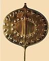
On the Mutta (or Muota = pre-Roman hill) a part of a settlement from the Bronze Age was excavated from 1935 to 1943. The most important find was a 83 cm long bronze disc needle that was found on July 23, 1943. It is dated to around 1600 BC. Dated. It could have served as a calendar with which the synodic orbital period of the planet Venus can be calculated from 584/585 days. The original of this worldwide unique find is exhibited in the Rhaetian Museum in Chur.
The most enigmatic figure on Mutta is the laughing face of a little man engraved in a Verrucanoblock . The 'laughing megalithic' looks to the northwest, at sunset during the summer solstice. The figure was discovered by Ignaz Cathomen in September 1984. Your age is indefinite.

Original of the disc needle
Copy of the disc needle
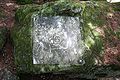
The 'laughing megalithic'


Parc la Mutta megalithic complex
The Planezzas plateau north of the Mutta and east of the Church of St. Remigius is an important megalithic place of worship and astronomy. The many stone settings were used both for cult acts and to calculate the calendar days. For arable farming at this altitude, precise knowledge of the beginning of spring and autumn was of vital importance for sowing and harvesting. The plant comprises Peilsteine for determining the summer solstice , the Bauer Winters, the winter solstice , the north-south direction, the equinox , the star Keph the Cassiopeia . A stone triangle in the center of the complex shows the ratio of the third row of the Pythagorean numbers 8:15:17. A stone with a moon arrow indicates a solar eclipse in 1089 BC. Chr. The inclination of the sun or calendar stone corresponds exactly to the inclination of the earth's axis. The system is connected to the environment by bearing lines. For example, the three churches of Falera, Ladir and Ruschein are on the same southwestern cult line.
Planet path
In the summer of 2003, on the initiative of the Astronomical Society of the Canton of Graubünden, a 1.4 km long planetary path was created on the first part of the panoramic path from Falera to Larnags / Laax .
Mirasteilas observatory

The observatory is located a little above the municipality in Falera and was opened on June 22, 2007. Their showpiece is a 1.6 tonne Cassegrain telescope, which is expensive for 300,000 francs, with a diameter of 90 centimeters and a focal length of 9 meters.
Mirasteilas is one of those Swiss observatories that observe asteroids, comets and satellites and measure their orbits. The data are sent to the Minor Planet Center of the International Astronomical Union at Harvard University in Cambridge (USA) and from there to the US space agency NASA .
On May 26, 2010 the International Astronomical Union and the Minor Planet Center of Harvard University in Cambridge gave the name "Falera" to the asteroid with the serial number 233943.
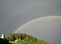
St. Remigius Church with rainbow
Menhir on Planezzas

Menhirs in front of St. Remigius

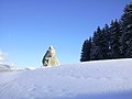
The mother with the Church of St. Remigius

Menhir above Falera


literature

- Ulrich Büchi, Greti Büchi: The megaliths of the Surselva, Graubünden. Volume 8: The menhirs on Planezzas / Falera. 3rd, expanded edition. G. Büchi, Forch 2002, ISBN 3-905223-00-7 .
- Ignaz Cathomen, Giusep Venzin: Falera St. Remigius. (= Peda art guide. No. 42). Kunstverlag Peda , Passau 1991, ISBN 3-927296-35-X .
- Ignaz Cathomen, Isidor Winzap: Falera. The history and development of a Graubünden mountain village. Falera municipality, Falera 2002.
- Ignaz Cathomen: Falera - our life hangs on a rope: autobiography of a village in Graubünden. Verlag Neue Zürcher Zeitung NZZ Libro, 2016. ISBN 978-3038101956
- Adrian Michael: magic rings. A fantastic story from Falera. Fröhlich Verlag, Zollikon 2001, ISBN 3-9521916-4-7 .
- Weisse Arena AG (Ed.): The mountain calls. We also. Echoes from the peripheral area . Edition Hochparterre , 2012
- Adolf Collenberg: Falera. In: Historical Lexicon of Switzerland . 2005 .
Web links
- Falera on the ETHorama platform
- Official website of the municipality of Falera
- Megalithic place of worship Parc la Mutta
- Bronze Age Astronomy (PDF file; 770 kB)
- Mirasteilas observatory
Individual evidence
- ↑ Permanent and non-permanent resident population by year, canton, district, municipality, population type and gender (permanent resident population). In: bfs. admin.ch . Federal Statistical Office (FSO), August 31, 2019, accessed on December 22, 2019 .
- ↑ Hiking Switzerland on the Senda Sursilvana to Falera
- ↑ Planet Path ( Memento of the original from December 25, 2015 in the Internet Archive ) Info: The archive link was automatically inserted and not yet checked. Please check the original and archive link according to the instructions and then remove this notice. (PDF; 1.2 MB)
- ↑ Hochparterre ( Memento of the original from December 22, 2012 in the Internet Archive ) Info: The archive link was inserted automatically and has not yet been checked. Please check the original and archive link according to the instructions and then remove this notice.
Breil / Brigels | Disentis / Mustér | Falera | Ilanz / Glion | Laax | Lumnezia | Medel (Lucmagn) | Obersaxen Mundaun | Safiental | Sagogn | Schluein | Sumvitg | Trun | Tujetsch | Vals
Former parishes: Andiast | Camuns | Castrisch | Cumbel | Sword | Duvin | Flond | Ilanz | Ladir | Lumbar clean | Luff | Morissen | Mundaun | Obersaxen | Peiden | Pigniu | Pitasch | Riein | Rueun | Ruschein | Safien | Slim | Schnaus | Sculms | Sevgein | Siat | St. Martin | Strada | Suraua | Surcasti | Surcuolm | Tenna | Tersnaus | Uors | Uors-Peiden | Valendas | Vella | Versam | Vignogn | Vrin | Waltensburg / Vuorz
Canton of Graubünden | Regions of the Canton of Graubünden | Municipalities of the Canton of Graubünden