
Parc la Mutta

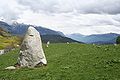
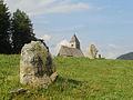
The Parc la Mutta ( Rhaeto-Romanic Mutta 'hilltop') is a row of stones created in the Middle Bronze Age near Falera in the Surselva in the Swiss canton of Graubünden . With a length of 400 m and 36 menhirs, it is the largest of its kind in Switzerland. In addition to several astronomical rows of stones, there are also bowl stones .
General

The facility is located on the southern outskirts of Falera above Laax at an altitude of around 1250 m. Most of the stones are on the Planezzas plain above the parking lot at the entrance to the village north of the Mutta, a prominently forested hill. The menhirs are boulders made of granite or diorite , the largest is more than two meters high. A large part of the stones must have been brought to Planezzas from the slope above the village. The more than 1000 year old church of St. Remigius is in the immediate vicinity .
With the help of information boards and provided plans, visitors can find out more about the facility. In the summer season there are guided tours through the facility.
discovery

In 1935, the district forester Walo Burkart , who had already discovered the Crestaulta settlement in the same year , drew attention to "six columnar boulders". He stated the distances between the stones at 19 m or a multiple thereof. In 1948 J. Maurizio recognized the astronomical orientation of the main line.
In 1976 Ulrich and Greti Büchi described rows of stones from which individual stones had been removed. Radiocarbon dating of a piece of charcoal from the clay foundation of a menhir revealed a period between 1500 and 1200 BC. BC, the transition between the middle and late Bronze Age . However, since it is the only such analysis, the result should not be given too much importance. The date of origin of the large row of stones facing the Tamins Calanda remains uncertain.
After the local Ignaz Cathomen and the Zurich geologist Ulrich Büchi had erected some megaliths on their own initiative in 1986 , without any methodological and archaeological documentation, the original location of a further 27 stones was excavated in 1988 on behalf of the municipality and under the direction of Ulrich Büchi determined and this upright again. In the summer of 2000 and 2001 a further nine menhirs were erected under the supervision of Jürg Rageth from the Archaeological Service of the Canton of Graubünden. The work was made possible by the Margrit Bohren-Hoerni Foundation. The original location of the fallen stones has been recorded in several aerial photographs since July 1939.

In order to anchor the stones, the builders first put a solid layer of clay into the pit. The menhir was tipped into this clay bed and turned into the desired position. Then it was wedged with elongated stones, then the pit was filled with moraine debris and humus. During excavations to locate the original position of the menhirs, no usable ceramic fragments were found . Pieces of ocher and charcoal residues , as well as stones that were used for wedging, were also found. The original foundation pits could only be found in around half of the menhirs that were erected again, especially on the Planezzas plain . On the slope facing the sports field, the original position of the stones in the row facing Piz Muraun could have been changed by erosion and small landslides. This orientation towards Piz Muraun goes back to the observations of Georg Brunner.
Bearings

Most of the alignments of the stone rows on Planezzas indicate significant sunrise and sunset points in the course of the year. The main line runs slightly downwards in a north-easterly direction and consists of five menhirs. It is possible that others fell victim to the stone robbery. The line shows a month before and after the summer solstice to the rising point of the sun on Taminser Calanda . These two days are to be counted from the spring equinox.
The extension of the row of stones in the opposite direction points to the church area of Ladir , where stones were set before the rectory was built. The continuation does not lead to the church area of St. Georg in St. Ruschein , but across the St. Anton chapel to the Frundsberg ruins. Bronze Age finds have been made in various places on the Crest da Ruschein. There are also many cup stones on this crest. If you continue the line in a westerly direction, it also leads over the St. Magdalena Chapel west of Schnaus and over St. Martin in Obersaxen. A total of five churches or chapels are located on the same 62 ° axis: Schnaus , Ruschein, Ladir, Falera and Laax (St. Nicholas Chapel).
In the main line, two menhirs together with a third form the corner points of a Pythagorean triangle with the aspect ratio 8:15:17. The hypotenuse corresponds to the direction of the main line, the legs are north-south or east-west.
The main sequence is intersected by another row of six blocks, the meaning of which was thought by the archaeo-astronomer Gion Gieri Coray from Luven in connection with the star Caph in the constellation Cassiopeia . As a result of the precession , however, the same values no longer apply to the stellar reference points as in the Bronze Age. Coray, however, considers this interpretation to be questionable.
Further bearing lines point to the sunrise point at the time of the summer solstice, to the sunset point at the time of the winter solstice, and the equinoxes of day and night . There are no indisputable references to the southern lunar extreme every 18.66 years.
Main alignment to the point of sunrise 30 days before and after the summer solstice
Same alignment to the west

Alignment for sunrise on May 21st and July 21st

Alignment at sunrise to the equinox


Stones
Around the mother, next to several shell stones, there are some worked stones. The most important of these are mentioned below.
Moon arrow

To the west of the stairway to Remigius Church, a 60 centimeter long arrow on a stretched bow is engraved on a stone. The arrowhead points to that part of heaven where a 96 percent solar eclipse could be observed on December 25, 1089 BC at 10:17 a.m. The sun appeared as a moon-shaped crescent when it was maximally covered by the moon, which explains the appearance of a crescent moon at the tip of the arrow. More recent calculations of this solar eclipse, which was centuries before the last, historically precisely understandable, postponed the event for the Surselva before sunrise. The peculiar shapes on this piece of rock are badly eroded, interpretations are hypothetical.
Sunstone

On the southwest side of the Mutta on the lower walkway there is an inclined stone slab with an incised circle 120 centimeters in diameter, a hole as the center, a small circular bowl at the top left and an 8 centimeter long notch running from east to west. However, its inclination deviates by several degrees from the inclination of the earth's axis and the surface does not sweep nearly exactly in a west-east direction. It remains questionable whether the times for the summer solstice or for November 11 (St. Martin's Day) and February 2 (Maria Candlemas) could be determined. The stone can still function like a sundial to this day. Since it is located in very steep terrain, its current location must not necessarily be the same as that a few thousand years ago.
Cross stone

In front of the entrance to the cemetery of the Church of St. Remigius on the right hand side is a granite block, on the almost flat surface of which stands a cross with bowl-shaped indentations at the ends of the arms. Its longitudinal bars are oriented east-west, the sunrise at the equinox z. E.g., but cannot be observed from this location.
A second, smaller cross, which is less deep, branches off from the southern arm of the cross. A point is engraved between the arms of the cross, which is only visible in very flat lighting. A longitudinal bar that points to Piz Mundaun must rather be seen in connection with the position of the sun (points towards the winter solstice on the horizon). So it is not a southern lunar extremity, as was assumed. The fact that he was neither involved nor relocated during the construction of the cemetery wall, which runs past him at a distance of a few centimeters, suggests that the stone and its location were respected for centuries.
The "laughing megalithic"

On September 23, 1984, the local Ignaz Cathomen discovered a rock carving on a large stone block from Illanzer Verrucano on the southwest side of Mutta . It shows a laughing human face with a kind of crown or hair. A lance tip can be seen next to the shoulder - or the upper part of the disc needle, as it was dug up on Mutta. The image looks northwest to the point of sunset at the time of the summer solstice. The time at which the representation was created is unknown.
"La Mutta" hill

The Mutta, a wooded hill shaped by mighty verrucoano blocks, rises around 50 meters above the plain of Planezzas and can be reached from several sides via small paths. Excavations around 1935 by the district forester Walo Burkart showed that there were settlements on the hill. Archaeological finds show an occupancy between 1800 and 400 BC, i.e. from the Bronze Age to the later Iron Age. One Iron Age and five Bronze Age soil layers have been verified.
The populated area occupied around 1500 square meters. Presumably between 60 and 120 people lived there in log houses. The settlement was surrounded by a mighty wall with a foundation width of two meters and a crown width of three meters. The gate system was located in the north-northwest and can still be seen today. The walls are overgrown today and can only be guessed at.
The discovery of a hearth with ceramic remains from false fires proves that pottery was made here; the ornamentation of the finds is related to that of Crestaulta . In addition to ceramic shards, five bronze sickles and over fifty millstones were found; a sign that arable farming was practiced here. The most important find, however, is that of a large bronze disc needle .
Disc needle

Original of the disc needle
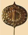
Copy


The disc needle was found on July 23, 1943 in the third bottom layer and dated to the early Bronze Age. It is 83 centimeters long, the oval head measures 16.5 by 12.5 centimeters. It consists of two pieces, the head with embossed humps and engraved lines and the forged thorn. In its demeanor, it is similar to a garment needle of the women's costume of that time, a so-called disc needle, but with 83 cm (instead of the usual 20 cm), oversized. It is one of a kind. William Brunner, astronomer and meteorologist (Flugwetter-Dienst), interpreted the humps and lines as a representation of a synodic orbital period of Venus . The length of the needle of 83 centimeters is also related to the so-called megalithic cubit, a controversial thesis postulated by A. Thom in the study of stone circles on the British Isles. The needle was preserved in the laboratory of the National Museum Zurich and is exhibited in the Rhaetian Museum in Chur .
Astronomical interpretation
The astronomical interpretation of rows of stones is less controversial today than it is already. That of cup stones remains, for they may have served many different purposes. As so-called miren (direction finding devices) they are rather imprecise because the 'rear sight' and 'front sight' are too close together. At least there are some (such as the so-called Tyrannenstein on the southern slope of the Ruscheiner Krete) that point with sufficient accuracy to a point on the horizon on a significant calendar day, such as the equinox. Nevertheless, skepticism is appropriate, because there is a risk of interpreting bearing lines that the builder may not have planned at all or that may be satisfied with the approximate. So there is z. B. no exact south line from the ruins of Frundsberg or the church of St. Georg in Ruschein to the Teufelstein in Peilertal near Vals.
As a scientific discipline, archaeoastronomy and ethnoastronomy have recognized representatives, especially in the USA (e.g. EC Krupp or Anthony Aveni) and in Great Britain (e.g. Audry Burl or Clive Ruggles). Wolfhard Schlosser and Burkard Steinücken are among the most important researchers in Germany.
literature

- Ulrich Büchi, Greti Büchi: The menhirs on Planezzas / Falera (= The megaliths of the Surselva, Graubünden. Vol. 8). 3rd, expanded edition, by Greti Büchi and Sibylle Späni-Büchi. G. Büchi, Forch 2002, ISBN 3-905223-00-7 .
- Christian Caminada : Graubünden, the enchanted valleys. The prehistoric cults and customs in ancient Raetia. New edition. Desertina-Verlag, Disentis 1986, ISBN 3-85637-115-X (Earlier editions as: The Enchanted Valleys. ).
- Ignaz Cathomen, Isidor Winzap: Falera. The story of the development of a mountain village in Graubünden. Falera municipality, Falera 2002.
- Julius Maurizio: The stone setting of Mutta near Fellers and its cult-geographical significance. In: Ur-Schweiz. Vol. 12, 1948, ISSN 1012-0122 , pp. 27-30.
- Adrian Michael: magic rings. A fantastic story from Falera. Fröhlich, Zollikon 2001, ISBN 3-9521916-4-7 .
Web links
- Adolf Collenberg: Falera. In: Historical Lexicon of Switzerland .
- Megalithic place of worship Parc la Mutta
- Bronze Age Astronomy (PDF, 770 KiB)
Individual evidence
- ↑ Geomatic investigation ( page no longer available , search in web archives ) Info: The link was automatically marked as defective. Please check the link according to the instructions and then remove this notice.
Coordinates: 46 ° 48 '0 " N , 9 ° 14' 8" E ; CH1903: seven hundred and thirty-seven thousand one hundred and sixty-five / 184774