
Tamins
| Tamins | |
|---|---|
 |
|
| State : |
|
| Canton : |
|
| Region : | In the ground |
| BFS no. : | 3733 |
| Postal code : | 7015 |
| Coordinates : | 750 013 / 188419 |
| Height : | 662 m above sea level M. |
| Height range : | 567–3243 m above sea level M. |
| Area : | 40.74 km² |
| Residents: | 1217 (December 31, 2018) |
| Population density : | 30 inhabitants per km² |
| Website: | www.tamins.ch |
 Tamins |
|
| Location of the municipality | |
  |
|
Tamins ( Rhaeto-Romanic ) is a municipality in the Imboden region of the canton of Graubünden in Switzerland . It is located around 10 km west of Chur .
geography

Under the castle rock of the district Reichenau , the united front and rear Rhine to the Rhine . To the west of the Reichenau-Tamins train station in the Ems municipality, the Rhaetian Railway separates from Chur: One line runs via Thusis into the Engadine , the other via Disentis to Andermatt . After crossing the Vorderrhein, this line lies up to the level of the Wackenau ruins in the Tamins area.
The municipality extends beyond the Kunkelspass to the north into the Tamina valley . Above this area and the Grossalp there, the municipal area extends into the high mountains with the Ringelspitz as the highest point at over 3200 meters. The SAC Ringelspitzhütte completes the alpine character.


coat of arms
Blazon : In green, a six-pointed golden (yellow) star
A community seal from 1799 already showed the star. Later coats of arms also showed the star in the blue field above the green three-mountain .
history
During the excavation of a building site southeast of the church hill, settlement remains were found, which most likely go back to the Neolithic . According to the Graubünden Archaeological Service, such a settlement is among the oldest sites in the canton.
population
| Population development | |||||||||||||
|---|---|---|---|---|---|---|---|---|---|---|---|---|---|
| year | 1850 | 1888 | 1900 | 1930 | 1950 | 1980 | 1990 | 2000 | 2005 | 2010 | 2012 | 2014 | 2016 |
| Residents | 770 | 585 | 863 | 618 | 781 | 946 | 1112 | 1167 | 1163 | 1184 | 1222 | 1226 | 1201 |
languages
The language change in Tamins from the Romansh language to German took place very early on. When exactly is unknown. But there was always a small minority of Romansh speakers. You speak a Central Grisons dialect, but traditionally use Surselv as a written language.
The following table shows the development over the last few decades:
| Languages in Tamins GR | ||||||
| languages | 1980 census | 1990 census | 2000 census | |||
| number | proportion of | number | proportion of | number | proportion of | |
| German | 795 | 84.04% | 962 | 86.51% | 1032 | 88.43% |
| Romansh | 67 | 7.08% | 62 | 5.58% | 41 | 3.51% |
| Italian | 59 | 6.24% | 42 | 3.78% | 33 | 2.83% |
| Residents | 946 | 100% | 1112 | 100% | 1167 | 100% |
Origin and nationality
Of the 1163 residents at the end of 2005, 88% were Swiss citizens.
Attractions
- Tamins Reformed Church
- Emserbrücke, iron road bridge over the Rhine near Reichenau
- Hinterrheinbrücke Reichenau of the Rhaetian Railway
- Bass castle and garden
- Watermill
- Asphalt processing plant Catram, 2002, architect: Kurt Lazzarini
- Road bridge over the Lavoitobel
Personalities
- Jakob Ragaz (1846–1922), architect
- Leonhard Ragaz (1868–1945), reformed theologian
- Georg Thürer (1908–2000), literary scholar and historian
- Hans Jürg Domenig (* 1964), entrepreneur
literature
- Jürg Rageth, Linus Bühler: Tamins. In: Historical Lexicon of Switzerland . 2013 .

village street

Schlosshotel Adler, in the background the top of the Tamins church tower and the Kunkelspass
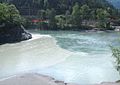
Rhine confluence


Web links
- Tamins on the ETHorama platform
- Official website of the municipality of Tamins
Individual evidence
- ↑ Permanent and non-permanent resident population by year, canton, district, municipality, population type and gender (permanent resident population). In: bfs. admin.ch . Federal Statistical Office (FSO), August 31, 2019, accessed on December 22, 2019 .
- ↑ Lia Rumantscha (Ed.): Romansh - Facts & Figures. 2nd, revised and updated edition. Chur 2004, ISBN 3-03900-034-9 . P. 31.
- ^ Road bridge over the Rhine
- ↑ Catram asphalt processing plant
- ↑ Road bridge over the Lavoitobel