
Wackenau Castle
| Wackenau ruins | ||
|---|---|---|
 Rest of the shield wall from the south |
||
| Castle type : | Hill castle, spur location | |
| Conservation status: | ruin | |
| Construction: | Rubble stones | |
| Place: | Bonaduz | |
| Geographical location | 46 ° 49 '25.3 " N , 9 ° 22' 31" E | |
| Height: | 630 m above sea level M. | |
|
||

The ruins of Wackenau Castle are located in the municipality of Bonaduz in the Swiss canton of Graubünden .
location
The sparse ruins of the former spur castle are at 630 m above sea level. M. about three kilometers northwest of the community in a typical spur position above a loop of the Vorderrhein . It can be reached on foot in around twenty minutes from a parking lot west of Bonaduz. Since the construction of the Punt Ruinaulta , the ruins can also be reached from the RhB train station in Trin.
Immediately above the hill of ruins, the viewing platform named after the castle offers a wide view of the Ruinaulta .
Surname
Ulrich Campell mentions a castle Wackenauv or Wackenoug around 1573 and interprets the name as “guard over the Au” or “waking eye”. Fortunat Sprecher mentions the name Vackenou in 1617 . This designation (Wacke = field stone, pebble) corresponds very precisely to the location of the castle above the considerable debris that the Vorderrhein deposited here.
investment
The castle was protected on the mountain side by a prominent neck ditch . The course of the plateau was followed by a surrounding wall , remains of which can still be seen in the west. The Bering was built as a strong shield wall over the moat . Round scaffolding lever holes can be seen in the quarry stones . Inside the facility there are barely noticeable traces of a building with a wall thickness of originally 0.85 meters in the northeast. Traces of a tower are missing. Remnants of a cistern that Erwin Poeschel found towards the end of the 1920s are no longer recognizable.
Around 2010 the castle hill was cleared of trees and scrub.
history
There are no written documents about the development and history of Wackenau Castle. The remains of the wall do not allow any conclusions to be drawn about the building. The castle probably served to protect the road to Trin , which led over a bridge here.
gallery

Looking north

Beringrest to the west

Castle hill
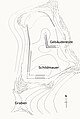
Layout


literature
- Otto P. Clavadetscher, Werner Meyer : The castle book of Graubünden . Orell Füssli, Zurich 1984, ISBN 3-280-01319-4 .
- Heinrich Boxler: The naming of castles in northeastern Switzerland and in Graubünden. Huber, Frauenfeld 1976
- Castle map of Switzerland. With detailed maps and description of the property . = Carte des châtaux de la Suisse. Avec cartes de detail et description of the objet . = Carta dei castelli della Svizzera. Con carte dettagliate e descrizione degli oggetti . Federal Office for Topography swisstopo, Wabern 2007, (1: 200,000).
- Anton von Castelmur: The castles and palaces of the Canton of Graubünden Volume II, Birkhäuser, Basel 1940
Web links
Individual evidence
- ↑ Basaltwacke . In: Meyers Konversations-Lexikon . 4th edition. Volume 2, Verlag des Bibliographisches Institut, Leipzig / Vienna 1885–1892, p. 415.
- ^ Heinrich Boxler, The naming of castles in northeastern Switzerland and in Graubünden ; P. 115

Episcopal Castle Fürstenau | Old Aspermont | Old Süns | Balcun At | Baldenstein | Bear Castle | Belfort | Belmont | Bernegg | Brandis | Cagliacha | Calanca | Campell | Cana scarf | Cartacha | Castelberg | Castelmur | Castels | Castrisch | Crap da Sass | Crap Sogn Parcazi | Ehrenfels | Fracstein | Falkenstein | Frauenberg | Friberg (Siat) | Friberg (Trun) | Friedau | Grafenberg | Greifenstein | Grotto stone | Grüneck | Grünenfels | Guardaval | Haldenstein Castle | Haldenstein Castle | Hasensprung | Heidenberg | Heinzenberg | High Juvalt | Hohenbalken | High Councilors | Innerjuvalt | Jörgenberg | Kapfenstein Castle | Blade horn | Kropfenstein | Lagenberg | La Serra dam | La Tur | Lichtenstein | Löwenberg | Lion's Arch | Marmels | Marschlins | Mesocco | Moregg | New Aspermont | New Süns | Neuburg | Nivagl | Norantola | Ober-Ruchenberg | Obertagstein | Ortenstein | Piping | Pontaningen | Rappenstein | Rhäzüns | Rietberg | Ringgenberg | Riom | Rohan | Salenegg | Salons | Saxenstein | Schauenstein | Schiedberg | Tower of Schlans | Schwarzenstein | Serviezel | Solavers | Spaniola | Splash | Splügen | Sta. Maria in Calanca | Steinsberg | Strahlegg | Strassberg | Surcasti | Tarasp | Torre Palas | Tschanüff | Tuor | La Praschun Tower | Turraccia | Valendas | Vogelberg | Wackenau | Wildenberg (Falera) | Wildenberg (Zernez) | Wynegg