
Serviezel ruins
| Serviezel Castle | ||
|---|---|---|
 Castle plateau |
||
| Creation time : | 12th Century | |
| Castle type : | Hilltop castle | |
| Conservation status: | ruin | |
| Place: | Tschlin | |
| Geographical location | 46 ° 52 '59 " N , 10 ° 27' 10" E | |
| Height: | 1230 m above sea level M. | |
|
||

The ruins of the Serviezel ruins are in the area of the municipality of Valsot west of Martina in the Lower Engadine in the Swiss canton of Graubünden .
location
The ruins of the hill fort are at 1230 m above sea level. M. on an elongated rock between two ravines between Martina and Tschlin . The castle can be reached on foot in just over half an hour from Martina. The last part of the way is hard to find, extremely steep and only recommended for experienced climbers.
investment
Some of the remnants of the northern enclosure wall have been preserved surprisingly well. Only a small remnant of the southern curtain wall can be seen. The plateau itself is heavily overgrown, nothing can be seen of the former buildings. Some rectangular terraces indicate overbuilding.
In the summer of 2011, the path to the ruin was repaired and an information board was installed. Shrubs and trees that had overgrown the facility were removed.
history
As with the Ramosch ruins of the same name, there is also a lack of written documents about the building and history of the castle. Ulrich Campell mentioned in 1573 that the castle was called Chaistelg Ser Guietzel by the locals . The name Serviezel can therefore be derived from "Mr. Wezzel". A Wezzel is mentioned by the Lords of Ramosch in 1148 as Wezel de Remuscie and in 1150 as Wezelo de Ramuscia . When and under what circumstances the castle was abandoned is not known.
gallery

Castle hill
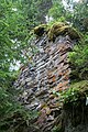
Northern Bering Corner

Demolition of the wall in the north

North corner

Rest of the south wall


literature
- Heinrich Boxler, naming castles in north-eastern Switzerland and in Graubünden , Huber Verlag, Frauenfeld 1976
- Otto P. Clavadetscher, Werner Meyer : The castle book of Graubünden . Zurich 1984, ISBN 3-280-01319-4
- Castle map of Switzerland, Federal Office of Topography , 2007 edition
Web links

Episcopal Castle Fürstenau | Old Aspermont | Old Süns | Balcun At | Baldenstein | Bear Castle | Belfort | Belmont | Bernegg | Brandis | Cagliacha | Calanca | Campell | Cana scarf | Cartacha | Castelberg | Castelmur | Castels | Castrisch | Crap da Sass | Crap Sogn Parcazi | Ehrenfels | Fracstein | Falkenstein | Frauenberg | Friberg (Siat) | Friberg (Trun) | Friedau | Grafenberg | Greifenstein | Grotto stone | Grüneck | Grünenfels | Guardaval | Haldenstein Castle | Haldenstein Castle | Hasensprung | Heidenberg | Heinzenberg | High Juvalt | Hohenbalken | High Councilors | Innerjuvalt | Jörgenberg | Kapfenstein Castle | Blade horn | Kropfenstein | Lagenberg | La Serra dam | La Tur | Lichtenstein | Löwenberg | Lion's Arch | Marmels | Marschlins | Mesocco | Moregg | New Aspermont | New Süns | Neuburg | Nivagl | Norantola | Ober-Ruchenberg | Obertagstein | Ortenstein | Piping | Pontaningen | Rappenstein | Rhäzüns | Rietberg | Ringgenberg | Riom | Rohan | Salenegg | Salons | Saxenstein | Schauenstein | Schiedberg | Tower of Schlans | Schwarzenstein | Serviezel | Solavers | Spaniola | Splash | Splügen | Sta. Maria in Calanca | Steinsberg | Strahlegg | Strassberg | Surcasti | Tarasp | Torre Palas | Tschanüff | Tuor | La Praschun Tower | Turraccia | Valendas | Vogelberg | Wackenau | Wildenberg (Falera) | Wildenberg (Zernez) | Wynegg
