
Grafenberg Castle
| Grafenberg | ||
|---|---|---|
 Grafenberg ruins |
||
| Alternative name (s): | Murderer's castle | |
| Creation time : | 13th Century | |
| Castle type : | Hilltop castle | |
| Conservation status: | ruin | |
| Place: | Bottle | |
| Geographical location | 47 ° 2 '46 " N , 9 ° 30' 46" E | |
| Height: | 750 m above sea level M. | |
|
||

The ruins of the former Grafenberg Castle , also popularly known as the Murderer's Castle , lie to the west above the road from Maienfeld to Balzers in the Swiss canton of Graubünden . The castle belongs to the Liechtenstein municipality of Balzers, but is located in the area of the Swiss municipality of Fläsch .
location
The ruins of the hill fort are at 750 m above sea level. M. on an elongated rock head not far from the border with the Principality of Liechtenstein. The facility can be easily reached from the road in about a quarter of an hour via a forest path (no driving).
Surname
The name appears to the chroniclers Ulrich Campell around 1579 as Grafenberg , 1617 to Fortunat Sprecher as Castrum Graffenberg and 1742 to Nicolin Sererhard as Schloss Grafenberg . The castle is not mentioned in contemporary documents and is out of the question as the seat of a count family.
An explanation for the name can be found in a derivation by Grawinberg ; Middle High German grâ , grâwes for gray . The name can refer to the rocky surroundings or the castle itself. So the Grafenberg emerged from the Grawinberg , since the connection between the castle and a count seemed more plausible to the locals than with the color gray.
The name Mordtburg , documented as early as 1498, can be seen in connection with a legend according to which the robber barons living in the castle are said to have thrown the robbed merchants over the rocks. In reality, however, the name Mörderburg could express the hostile relationship between the residents and the lords of the castle.
investment
The castle hill is separated from the mountainside by an artificial neck ditch . A 25-meter-long and 6.5-meter-high wall of a hall with at least two floors was preserved from the complex on the northeast slope . In addition to the beam holes, there are four notch windows that open inwards to window niches. Further remains of the wall along the south-east and south-west edge of the plateau suggest that the building had a floor area of approx. 41 × 11 m and thus covered the entire summit of the hill.
A Letzi stretched from the foot of the castle hill to the Guschnerberg opposite , some remains of which are still preserved in the forest strip at the bottom of the valley. It was stormed by the imperial troops in the Swabian War on January 5, 1499 and after a few days of occupation it was recaptured by the Graubünden.
Investigation and security measures were carried out in autumn 2004.
history
There are no written documents about the origins and history of the castle. In 1498, the Mordtburg appears in a border description between Fläsch and Balzers. Masonry in Opus spicatum and fragments of cup-shaped stove tiles suggest that it was built in the 13th century. Fire debris inside the building suggests a fire.
gallery

View to the north
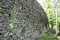
Northeast wall
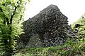
East wall with the patched light spots
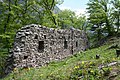
View from the west


literature
- Anton Mooser: The Murderer's Castle (Grafenberg) . Bündnerisches monthly newspaper. Journal of Graubünden history, regional and folklore, volume 1915, issue 12
- Otto P. Clavadetscher, Werner Meyer : The castle book of Graubünden . Zurich 1984, ISBN 3-280-01319-4
- Castle map of Switzerland, Federal Office of Topography, 2007 edition
- Anton von Castelmur: The castles and palaces of the Canton of Graubünden , Volume I, Birkhäuser-Verlag, Basel 1940
Web links
- Burgenwelt: Grafenberg Castle (Murder Castle)
- Florian Hitz: Grafenberg. In: Historical Lexicon of the Principality of Liechtenstein .
Individual evidence
- ↑ Annual Report Liechtenstein Preservation 2004 (PDF file; 3.37 MB)
- ↑ mhd dictionary
- ^ Heinrich Boxler, The naming of castles in northeastern Switzerland and in Graubünden ; Pp. 179f, 248

Episcopal Castle Fürstenau | Old Aspermont | Old Süns | Balcun At | Baldenstein | Bear Castle | Belfort | Belmont | Bernegg | Brandis | Cagliacha | Calanca | Campell | Cana scarf | Cartacha | Castelberg | Castelmur | Castels | Castrisch | Crap da Sass | Crap Sogn Parcazi | Ehrenfels | Fracstein | Falkenstein | Frauenberg | Friberg (Siat) | Friberg (Trun) | Friedau | Grafenberg | Greifenstein | Grotto stone | Grüneck | Grünenfels | Guardaval | Haldenstein Castle | Haldenstein Castle | Hasensprung | Heidenberg | Heinzenberg | High Juvalt | Hohenbalken | High Councilors | Innerjuvalt | Jörgenberg | Kapfenstein Castle | Blade horn | Kropfenstein | Lagenberg | La Serra dam | La Tur | Lichtenstein | Löwenberg | Lion's Arch | Marmels | Marschlins | Mesocco | Moregg | New Aspermont | New Süns | Neuburg | Nivagl | Norantola | Ober-Ruchenberg | Obertagstein | Ortenstein | Piping | Pontaningen | Rappenstein | Rhäzüns | Rietberg | Ringgenberg | Riom | Rohan | Salenegg | Salons | Saxenstein | Schauenstein | Schiedberg | Tower of Schlans | Schwarzenstein | Serviezel | Solavers | Spaniola | Splash | Splügen | Sta. Maria in Calanca | Steinsberg | Strahlegg | Strassberg | Surcasti | Tarasp | Torre Palas | Tschanüff | Tuor | La Praschun Tower | Turraccia | Valendas | Vogelberg | Wackenau | Wildenberg (Falera) | Wildenberg (Zernez) | Wynegg